Maps of Great Plains

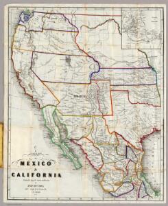
Map Of Mexico & California.
1 : 6000000 Hutawa, Julius
Composite: (U.S. West) Railroad Map of the United States.
1 : 1140480 Rand McNally and Company
Map Of The United States.
1 : 13168000 U.S. War Department, Topographical Engineers
Map of the United States and their territories between the Mississippi and the Pacific Ocean; and part of Mexico
1 : 3200000 United States. Topographical Engineers. United States. Topographical Engineers.
Vereinigten Staaten von Nordamerika, West-Hälfte
Geographischer Atlas über alle Theile der Erde Ziegler, Jakob Melchior Verlag von Joh. Wurster um Comp.
Vereinigte Staaten von NordAmer(ika, nebst Mexico und Centralamerika, West)
1 : 7000000 Stein, Christ. Gottfr. Dan.
Gray's Geological Map of the United States
from New illustrated atlas of Dutchess County, New York. / Compiled & drawn from personal examinations, surveys etc. under the personal supervision of O.W. Gray & Son and F.A. Davis, and published under the superintendence of H. L. Kochersperger.
Westliches-Nordamerica
Neuer Handatlas über alle Theile der Erde Kiepert, Heinrich Verlag von Dietrich Reimer
Nouvelle Carte du Mexique, Et D'Une Partie Des Provinces Unies De L'Amerique Centrale.
1 : 4800000 Brue, Adrien Hubert, 1786-1832
Nouvelle Carte du Mexique, Du Texas.
1 : 4800000 Brue, Adrien Hubert, 1786-1832
United States
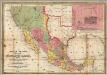
Mapa de los Estados Unidos De Mejico.
1 : 4430000 Disturnell, John
Black and White Mileage Map of the United States (western half).
1 : 5132000 Rand McNally and Company
Reduced section, general map, North America, 1795.
1 : 18000000 Winterbotham, W.
Map Of The Territory Of The United States From The Mississippi To The Pacific.
1 : 3000000 Warren, Gouverneur Kemble, 1830-1882
Reduced section, map of North America, 1826.
1 : 18000000 Warren, Gouverneur Kemble, 1830-1882
Map Of The Territory Of The United States From The Mississippi To The Pacific Ocean.
1 : 3000000 Warren, Gouverneur Kemble, 1830-1882
Mexico, Central America.
1 : 10000000 Morse, Sidney E. (Sidney Edwards), 1794-1871
Reduced section, territory west of Rocky Mountains, 1837.
1 : 18000000 Warren, Gouverneur Kemble, 1830-1882
Map Of The Territory Of The United States From The Mississippi To The Pacific Ocean.
1 : 3000000 Warren, Gouverneur Kemble, 1830-1882
Composite: Mexico.
1 : 2500000 Humboldt, Alexander von, 1769-1859
Mexico and Adjacent Provinces.
1 : 2450000 Humboldt, Alexander von, 1769-1859
United States

Mexico.
1 : 16500000 Lucas, Fielding Jr.
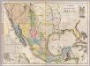
A Map Of The United States Of Mexico.
1 : 5195520 Tanner, Henry S.
Reyno de la Nueva Expana a Principios del Siglo XIX.
1 : 7349760 Garcia Cubas, Antonio, 1832-1912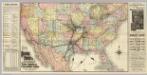
Missouri Pacific Railway.
1 : 7900000 Rand McNally and Company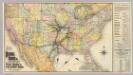
Iron Mountain Route.
1 : 7900000 St. Louis, Iron Mountain, and Southern Railway Company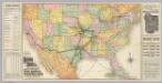
South West Railway System.
1 : 7900000 Rand McNally and Company