Maps of United States

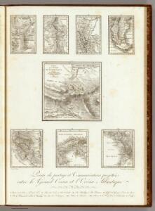
Points de partage et Communications projettees.
Humboldt, Alexander von, 1769-1859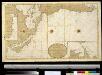
Nieuwe afteekening van de de Zuijdt Zee van C. de Hoorn tot California als ook het Compagnies Landt ent Land van Eza
America Gerard van Keulen
Totius Americae septentrionalis et meridionalis novissima repræsentatio
1 Karte : Kupferdruck ; 48 x 56 cm Homann J.B. Homann
Totius Americae septentrionalis et meridionalis novissima repræsentatio
1 Karte : Kupferdruck ; 47 x 56 cm Homann J.B. Homann
Totius Americae septentrionalis et meridionalis novissima repræsentatio
1 Karte : Kupferdruck ; 47 x 56 cm Homann J.B. Homann
America.
1 : 42000000 Wauthier, J. M.
Plain map America.
1 : 42000000 Wauthier, J. M.
(L'Amerique)
1 : 150000000 Bruyset, Jean-Marie; Schneider, J. H.
De Grote Oceaan
Pacific Ocean Gerard van Keulen
[Polynesien und der Grosse Ocean (östliches Blatt)]
Adolf Stieler's Handatlas über alle Theile der Erde und über das Weltgebäude Stieler, Adolf Justus Perthes
America
Stieler's Hand-Atlas Stieler, Adolf bei Justus Perthes
Mexico, or, New Spain : divided into the audiance of Guadalayara, Mexico, and Guatimala, Florida.
from New & accurate description of the earth in all its empires, kingdoms and states
[Carte de l'Empire Espagnol dans les deux Amériques en 1776]
1 : 2000000 Description géographique et statistique de la Confédération Argentine Martin de Moussy, Victor Librairie de Firmin Didot frères, fils et Cie
America cum supplementis poly-glottis
1 Karte : Kupferdruck ; 15 x 12 cm, Bildgrösse 16 x 20 cm Hensel; Dorn Homännische Erben
Pascaart vertoonende de zeecusten van Chili, Peru, Hispania Nova, Nova Granada, en California
1 Karte : Kupferdruck ; 43 x 55 cm Doncker by Hendrick Doncker boeckverkooper in de Nieuwe brugh steegh in 't Stuiermans gereedtschap
Facsimile: Part of America by Gussefeldt.
1 : 36000000 Gussefeldt, F.L.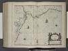
Pascaerte van Nova Hispania, Chili, Peru, en Gvatimala.
from De zee-atlas ofte water-wereld : waer in vertoont werden alle de zee-kusten van het bekende des aerd-bodems : seer dienstigh voor alle heeren en kooplieden, als oock voor alle schippers en stuurlieden / by Pieter Goos.
(World, gnomonic proj. II. America)
1 : 5000000 Society for the Diffusion of Useful Knowledge (Great Britain)
Mexico, or, New Spain : divided into the audiance of Guadalayara, Mexico, and Guatimala, Florida.
from System of geography with new maps
Ornamental map of the United States & Mexico / Barritt sc.
from Parts
Australie.

Stromgebiet von Nordamerica
Grosser Hand-Atlas über alle Theile der Erde in 170 Karten Meyer, J. Verlag des Bibliographischen Instituts
New Spain ; Guiana.
from A new systeme of the mathematicks: containing I. Arithmetick, as well natural and decimal, as in species, or the principles of algebra. II. Practical geometry, together with the first six books of Euclid's Elements, as also the eleventh and twelfth, symbo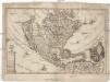
America borealis
1 : 32500000 Severní Amerika Scherer, Heinrich
A new and correct map of North America with the West India Islands : divided according to the last treaty of peace, concluded at Paris, 10th Feby. 1763 ; wherein are particularly distinguished, the several provinces and colonies, which compose the Britis
from Whole
Ethnographische Karte von Nordamerika
Zweiter Band, enthaltend in vier Abtheilungen die Vertheilung der Organismen: 5. Pflanzen-Geographie, 6. Thier-Geographie, 7. Anthropographie, 8. Ethnographie Humboldt, Alexander von Verlag von Justus Perthes
Johnson's new illustrated & embellished county map of the republics of North America : with the adjacent islands & countries / compiled, drawn & engraved from U. States land & coast surveys, British Admiralty & other reliable sources by D. Griffing Johns
from Parts
America Septentrionalis. [Karte], in: Novus atlas absolutissimus, Bd. 6, S. 197.
1 Karte aus Atlas Janssonius Offizin