Maps of Contra Costa County

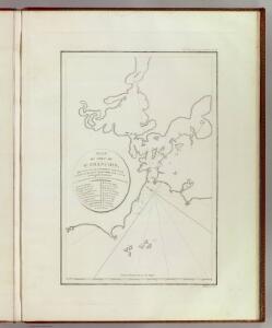
Port de St. Francois.
1 : 420000 La Perouse, Jean-Francois de Galaup, comte de, 1741-1788
Port de St. Francois.
1 : 420000 La Perouse, Jean-Francois de Galaup, comte de, 1741-1788
San Francisco and vicinity, California / R.B. Marshall, chief geographer
1 : 62500 Annotatie geografische gegevens: Opname: 1892-1913, bebouwing herz. in 1913-1914 Marshall, R. B. [Washington, D.C. : U.S. Geological Survey]
Port De San Francisco Dans La Haute Californie.
Duflot de Mofras, Eugene
San Francisco
1 : 100000
San Francisco
1 : 100000
Official Map Of Marin County, California.
1 : 48000 Dodge, George M.
San Francisco and vicinity, California
1 : 62500 U.S. Geological Survey
San Pablo Bay, Carquines Straits.
1 : 455000 Stuart, F. D. (Fred. D.)
Composite: San Francisco Bay Area Structure Sections. 1914.
1 : 62500 Merriam, John C.
San Francisco entrance, California
1 : 40000 U.S. Coast and Geodetic Survey U.S.C.& G.S.
San Francisco entrance, California : 1884
1 : 40000 United States Coast Survey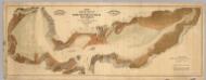
Map exhibiting the salt marsh ... lands adjacent to the bays of San Francisco and San Pablo.
1 : 50000 California. Board of State Harbor Commissioners for San Francisco Harbor
Marin County.
1 : 63360 Whitney, F.
United States - West Coast. San Francisco entrance, California.
1 : 40000 U.S. Coast and Geodetic Survey
San Francisco entrance, California.
1 : 40000 U.S. Coast and Geodetic Survey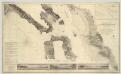
Entrance to San Francisco Bay California.
1 : 50000 United States Coast Survey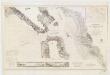
Entrance to San Francisco Bay, California
1 : 50000 United States Coast Survey The Survey
United States--West coast, san Francisco Entrance, California
1 : 50000 U.S. Coast and Geodetic Survey
San Francisco and vicinity, California
1 : 24000 Geological Survey (U.S.)
San Francisco Quadrangle. Topography.
1 : 62500 Lawson, Andrew C.
Tamalpais Quadrangle. Structure Sections.
1 : 62500 Lawson, Andrew C.
Drake's Bay, California.
1 : 40000 United States Coast Survey
Concord Quadrangle. Areal Geology.
1 : 62500 Merriam, John C.
Concord
1 : 62500
Tamalpais
1 : 62500
San Francisco
1 : 62500
San Francisco
1 : 62500
San Francisco
1 : 62500
San Francisco
1 : 62500
Concord
1 : 62500
Concord
1 : 62500
Concord
1 : 62500
San Francisco
1 : 62500
San Francisco
1 : 62500
San Francisco
1 : 62500
San Francisco
1 : 62500
San Francisco
1 : 62500
San Francisco
1 : 62500
Tamalpais
1 : 62500
Tamalpais
1 : 62500
Tamalpais
1 : 62500
Tamalpais
1 : 62500
Tamalpais
1 : 62500
Tamalpais
1 : 62500
Tamalpais
1 : 62500
Tamalpais
1 : 62500
Tamalpais
1 : 62500
Tamalpais
1 : 62500
Tamalpais
1 : 62500
Tamalpais
1 : 62500
Concord
1 : 62500
Concord
1 : 62500
Concord
1 : 62500