Maps of Torridge
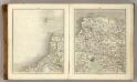
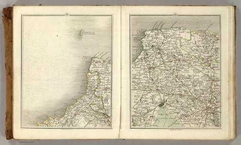
Sheets 11-12. (Cary's England, Wales, and Scotland).
1 : 360000 Cary, John, ca. 1754-1835
North Devon, Sheet 35 - Bartholomew's "Half Inch to the Mile Maps" of England & Wales
1 : 126720 Topographic maps Bartholomew, John George John Bartholomew & Co
Bude - OS One-Inch Map
1 : 63360 Topographic maps Ordnance Survey Ordnance Survey
Barnstaple - OS One-Inch Map
1 : 63360 Topographic maps Ordnance Survey Ordnance Survey
South Molton, Devon
This relief on this drawing,is indicated by dense interlining ('hachures'), with,the summits of hills left blank. The drawing has been made on three pieces of paper mounted as one sheet., Dirty, worn and creased, the manuscript is difficult to decipher. ,A pencil note at the base of the drawing reads "To survey from * to * as ...by...the Farms as named."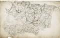
Barnstaple, Devon
The indication of land relief and attention to communication routes on this plan conform to the military and cartographic standards employed by the West Country survey. The south of England was the area most vulnerable to invasion, especially during the Napoleonic conflicts between 1793 and 1815. Accurate mapping of the Devonshire coastline was, therefore, of great military significance. Towards the left of the plan, the sand dunes of Braunton Burrows stretch southwards from the sea at Barnstaple Bay towards Appledore and Bideford.
Okehampton - OS One-Inch Map
1 : 63360 Topographic maps Ordnance Survey Ordnance Survey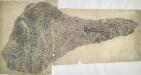
Oakhampton, Devon
1 : 31680 This dirty and worn plan is made from two pieces of paper conjoined. Place names are difficult to read. High Willhays (High Willhayse) and Yes Tor, two of Dartmoor's highest points, are badly obscured by the dense drawing style used to represent relief. A green wash indicates Dartmoor Forest. The remains of Oakhampton Castle are marked by a crosshatched mound. A red line passes through the drawing on the left edge. Two crosses may mark observation or triangulation points.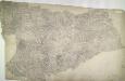
Holsworthy, Devon
Pencil annotations on the bottom right of the map give the surveyors name and the drawing's date and scale. A red dashed line denotes the border of Devon and Cornwall, running partly along the course of the River Tamer. Pencil rays intersect across the plan, evidence of triangulation measurements taken by the surveyor. Although it did not become obligatory to include archaeological details until 1816, prehistoric defensive earthworks are noted at Warbstow Barrow . A windmill is shown in elevation at Holsworthy. Budgen, Charles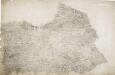
Hartland, Devon
A dashed red line marks the county boundary between Cornwall and Devon at the bottom left of the manuscript. Depicted throughout the area, Devon's mills provided the East India Company with woven serges by the ton until the early 19th century. Coarse woollen cloths, blankets and fine lace were also woven throughout the county. Budgen, Charles
Camelford, Cornwall (002OSD000000001U00009000)
Royal Military Draughtsmen and Surveyors were listed as first-class or second-class by the Tower of London Drawing Room according to the quality of their work. Robert Dawson, the draughtsman of this map, was an influential teacher at the Tower and rated first-class, while Henry Stevens, the surveyor, was rated only second-class.The orientation of this map does not have north at the top. Hence, the coastal boundary from Widemouth Bay south to Tintagel Castle runs from left to right along the bottom of the drawing. A faded blue-green wash indicates water. Brown Willy, the highest point in Cornwall, is shown on the northern edge of Bodmin Moor to the top right of the inland boundary. A turnpike road, coloured ochre yellow, runs from Launceston to Camelford. One side of the road is thickened and miles appear alongside in figures. The close attention given to communication routes highlights the military intent of these studies. At the same time, archaeological features and antiquities are also noted, reflecting the particular interests of individual surveyors or draughtsmen. In this instance, manganese mines are marked. Stevens, Henry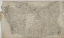
Crediton
.Wear and tear aorund the edges of this drawing have given it an irregular shape. The scale of the plan and date of execution are recorded in pencil in the bottom right corner. Major lines of communication, such as that between Credition and Newton St Cyres, are marked at intervals of one mile and tinted yellow, conforming to military cartographic convention. A blue cross at the edge of the map, near Hatherleigh, marks a reference point that may have been used for observation.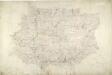
South Molton
1 : 31680 This drawing is delicately shaded and subtly coloured, with yellow-tinted communication routes and red-ink stone buildings. Indistinct triangulation lines, corresponding to focal points of the drawing, appear on the reverse of the manuscript. A rough pencil circle is drawn around South Molton, the largest settlement in the area.
Roborough
Topography and areas of natural shelter were both of great importance in planning,any military campaign., To this end, inclines and woodland are clearly indicated on this drawing., The main communication routes are highlighted in yellow., Some roads have been pin-marked along their lengths, proof that the draughtsman used measuring dividers to plot the exact course of the roads., The dates of draughting and the scale of the drawing have been recorded in pencil on the bottom right of the sheet. Hewitt, John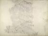
North Molton, Devon
Much of this drawing,is dominated by,the open land of the downs.,Relief is indicated by shading and brushwork interlining ('hachures') but there is no numerical,record of trigonometrical altitudes. Paths on the moor are distinguished from roads by their pecked lines; roads,through villages are indicated by parallel lines. Hewitt, John
Lundy Island (Outline) - OS One-Inch Revised New Series
1 : 63360 Topographic maps Ordnance Survey Ordnance Survey
Lundy Island (Outline) - OS One-Inch Revised New Series
1 : 63360 Topographic maps Ordnance Survey Ordnance Survey
Lundy Island (Hills) - OS One-Inch Revised New Series
1 : 63360 Topographic maps Ordnance Survey Ordnance Survey
Bude Bay (Outline) - OS One-Inch Revised New Series
1 : 63360 Topographic maps Ordnance Survey Ordnance Survey
Bude Bay (Hills) - OS One-Inch Revised New Series
1 : 63360 Topographic maps Ordnance Survey Ordnance Survey
Bude Bay (Outline) - OS One-Inch Revised New Series
1 : 63360 Topographic maps Ordnance Survey Ordnance Survey
Boscastle (Hills) - OS One-Inch Revised New Series
1 : 63360 Topographic maps Ordnance Survey Ordnance Survey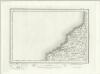
Boscastle (Outline) - OS One-Inch Revised New Series
1 : 63360 Topographic maps Ordnance Survey Ordnance Survey
Bideford (Hills) - OS One-Inch Revised New Series
1 : 63360 Topographic maps Ordnance Survey Ordnance Survey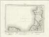
Bideford (Outline) - OS One-Inch Revised New Series
1 : 63360 Topographic maps Ordnance Survey Ordnance Survey
Bude (Hills) - OS One-Inch Revised New Series
1 : 63360 Topographic maps Ordnance Survey Ordnance Survey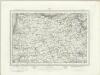
Bude (Outline) - OS One-Inch Revised New Series
1 : 63360 Topographic maps Ordnance Survey Ordnance Survey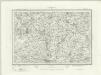
Holsworthy (Outline) - OS One-Inch Revised New Series
1 : 63360 Topographic maps Ordnance Survey Ordnance Survey
Holsworthy (Hills) - OS One-Inch Revised New Series
1 : 63360 Topographic maps Ordnance Survey Ordnance Survey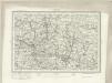
Barnstaple (Outline) - OS One-Inch Revised New Series
1 : 63360 Topographic maps Ordnance Survey Ordnance Survey