Maps of Paraguay
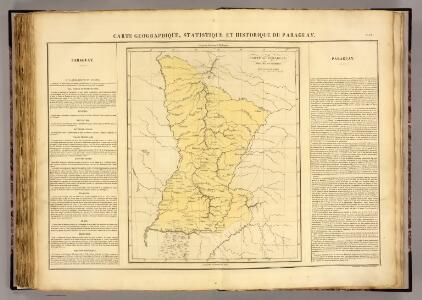
Paraguay.
1 : 2350000 Pierron, Jean Antoine
Partie, la Plata. Amer. Merid. 26.
1 : 1641836 Vandermaelen, Philippe, 1795-1869
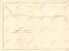
Map of the river Pilcomayo

Mapa de la Republica del Paraguay.
1 : 1490000 Paz Soldan, Mariano Felipe, 1821-1886
Gobernacion de Formosa.
1 : 1800000 Paz Soldan, Mariano Felipe, 1821-1886
Plano Nuevo de los Territorios del Chaco argentino
1 : 800000 Jorge Rohde Buenos Aires : G. Kraft
Partie, la Plata. Amer. Merid. 31.
1 : 1641836 Vandermaelen, Philippe, 1795-1869
Gobernacion de Chaco.
1 : 1800000 Paz Soldan, Mariano Felipe, 1821-1886
Gobernacion de Misiones.
1 : 1800000 Paz Soldan, Mariano Felipe, 1821-1886
Map of the river Pilcomayo
Map of the river Pilcomayo

[Cours inférieur et bouches du Rio Paraguay]
1 : 2000000 Description géographique et statistique de la Confédération Argentine Martin de Moussy, Victor Librairie de Firmin Didot frères, fils et Cie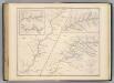
Carte, cours du Haut Uruguay, 2. flle. Uruguayana-Rio Pepiri-Guazu.
1 : 372000 Martin de Moussy, V. (Victor), 1810-1869
Plano de la Asunción al verso: fotografies dels edificis princiapls de la ciutat
1 mapa. Enciclopedia Ilustrada Seguí. Lam. I. Datat entre 1920 i 1929. Enciclopèdia Seguí
[Carte du cours du haut Uruguay]
1 : 2000000 Description géographique et statistique de la Confédération Argentine Martin de Moussy, Victor Librairie de Firmin Didot frères, fils et Cie
Carte du Grand Chaco et contrees voisines.
1 : 3750000 Martin de Moussy, V. (Victor), 1810-1869
Carte du Grand Chaco (Territoire Indien du Nord) et des Contrées voisines
1 : 2000000 Description géographique et statistique de la Confédération Argentine Martin de Moussy, Victor Librairie de Firmin Didot frères, fils et Cie
Charte eines Theils von Paraguay und der Provinz Buenos-Ayres
Paraguay Azara, Félix de
Carta geografica del Estado Oriental del Uruguay y posesiones adyacentes / trazada segun los documentos mas recientes y exactos ; publicada bajo la direccion del Sr. A. Roger, consul de Francia ; dedicada al Exmo.Sr. Presidente Gnal. D. Fructuoso Rivera
1 Mapa, b/n. Esquarterat i entelat Roger, A.
Carte Historique de la Province des Missions et des Établissements des Jésuites sur le Parana et l'Uruguay
1 : 2000000 Description géographique et statistique de la Confédération Argentine Martin de Moussy, Victor Librairie de Firmin Didot frères, fils et Cie
Carte hist., Prov. des Missions, etabl. Jesuites, Parana et l'Uruguay, 1575- 1768.
1 : 1870000 Martin de Moussy, V. (Victor), 1810-1869
Carte de la Province de Santiago del Estero et du Territoire Indien du Nord ou Grand Chaco
1 : 2000000 Description géographique et statistique de la Confédération Argentine Martin de Moussy, Victor Librairie de Firmin Didot frères, fils et Cie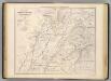
Carte, Prov. de Corrientes, Terr. des Missions, pays adjacents.
1 : 1850000 Martin de Moussy, V. (Victor), 1810-1869
Carte de la Province de Corrientes du Territoire des Missions et des Pays Adjacents
1 : 2000000 Description géographique et statistique de la Confédération Argentine Martin de Moussy, Victor Librairie de Firmin Didot frères, fils et Cie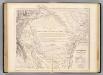
Carte, Province de Santiago del Estero, Grand Chaco.
1 : 1850000 Martin de Moussy, V. (Victor), 1810-1869
Partie du Bresil. Amer. Merid. 27.
1 : 1641836 Vandermaelen, Philippe, 1795-1869
Partie, la Plata. Amer. Merid. 30.
1 : 1641836 Vandermaelen, Philippe, 1795-1869
Provincia de Corrientes
1 : 1000000 Seelstrang, Arthur Eduard von 1838-1896 Buenos-Aires : J. Ruland
Provincia de Corrientes.
1 : 1800000 Paz Soldan, Mariano Felipe, 1821-1886