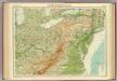
Maps of Ontario

An accurate map of Canada, with the adjacent countries: exhibiting the late seat of war between the English & French in those parts / R.W. Seale, del. et sculp.
from Canada R.W. Seale,
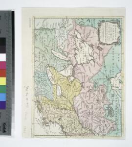
Copy of a map attached to Govr. Colden's History of the Five Indian Natio[ns] : printed in London, A.D. MDCCXLVII.
from Parts
Canada.
1 : 9000000 Tanner, Henry S.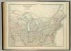
United States of North America (North East Sheet).
1 : 3984000 Johnston, W. & A.K.
Karten - Skizzen für die Schul - Praxis

Map of the Vermont Central Rail Road and its connections from Smith's map of the United States.
from Parts
Vereinigte Staaten Von Nord-Amerika In 6 Blattern, Bl. 3.
1 : 3700000 Petermann, A.
Pennsylvania and New Jersey.
from Parts
Map of the seat of war in North America / J. Melish del.; H. S. Tanner dirext.
from Parts John Melish; Henry S. Tanner,
Eastern Canada.
1 : 4800000 Schonberg & Co.
PARTIE OCCIDENTALE de la NOUVELLE FRANCE ou du CANADA
1 : 3600000 Velká kanadská jezera (Kanada a Spojené státy americké) Bellin, Jacques-Nicolas par le Heritiers de Homan
PARTIE OCCIDENTALE de la NOUVELLE FRANCE ou du CANADA
1 : 3600000 Velká kanadská jezera (Kanada a Spojené státy americké) Bellin, Jacques-Nicolas par les Heritiers de Homan
PARTIE OCCIDENTALE de la NOUVELLE FRANCE ou du CANADA
1 : 3600000 Velká kanadská jezera (Kanada a Spojené státy americké) Bellin, Jacques-Nicolas par les Heritiers de Homan
Northern section of the United States, including Canada &c. / by John Melish, 1816; grav. af. C. F. Himberg.
from Parts John Melish; C. F. Himberg,
[Die Vereinigten Staaten von Amerika in 6 Blättern, Blatt 3]
Adolf Stieler's Handatlas über alle Theile der Erde und über das Weltgebäude Stieler, Adolf Justus Perthes
This map of Upper and Lower Canada and United States.
1 : 3700000 Tardieu, P.F.
[Die Vereinigten Staaten von Nord-Amerika, Blatt 3]
Handatlas über alle Theile der Erde und über das Weltgebäude Stieler, Adolf Justus Perthes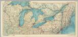
United States of America - Great Lakes. Pergamon World Atlas.
1 : 2500000 Polish Army Topography Service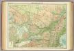
Ontario & Quebec.
1 : 2500000 John Bartholomew and Son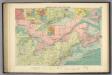
American Atlantic ports N.
1 : 5000000 Philip, George
Carte pour servir à l'itinéraire pittoresque du fleuve Hudson et des parties latérales de l'Amerique du Nord
1 : 4200000 Milbert, Jacques Gérard Gaugain, Henri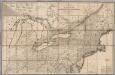
Map of the Canadas.
1 : 1267200 Taylor, David
Canada &c.
1 : 7350000 Lucas, Fielding Jr.
A Map Of Cabotia.
1 : 1457000 Whittle, J.
Nieuwe en nauwkeurige kaart van een gedeelte van Noord Amerika : behelzende Nieuw Engeland, New York, Pennsylvania, New Jersey, Connecticut, Rhode Island, een stuk van Virginia, Kanada en Halifax, ter opheldering der reizen van den Heer P. Kalm / C.J. de
from Reis door Noord Amerika, gedaan door den Heer Pieter Kalm ... Vercierd met koperen platen ...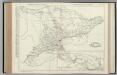
Ontario.
Rand McNally and Company
A new and general map of the middle dominions belonging to the United States of America: viz. Virginia, Maryland, the Delaware-counties, Pennsylvania, New Jersey &c. with the addition of New York, & of the greatest part of New England &c as also of the bordering parts of the British possessions in Canada.
from Parts Published by Laurie & Whittle, No. 53 Fleet Street ...: London; Robert Laurie and James Whittle,
Lay's map of the United States / compiled from the latest and best authorities and actual surveys by Amos Lay, geographer and map publisher ; engraved by O.H. & D.S. Throop & Wm. Chapin.
From Whole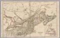
Upper Canada &c.
1 : 2154240 Arrowsmith, John