Maps of Les Laurentides

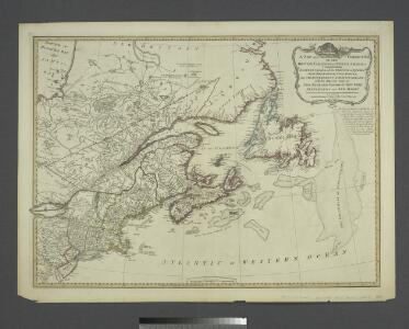
A New and correct map of the British colonies in North America comprehending eastern Canada with the province of Quebec, New Brunswick, Nova Scotia, and the Government of Newfoundland: with the adjacent states of New England, Vermont, New York, Pennsylvania and New Jersey.
from Charts and maps Publish'd by Laurie & Whittle, 53 Fleet Street: London; Robert Laurie and James Whittle,
British colonies North America, New England.
1 : 3800000 Robert Laurie & James Whittle
A New and correct map of the British colonies in North America comprehending eastern Canada with the province of Quebec, New Brunswick, Nova Scotia, and the Government of Newfoundland: with the adjacent states of New England, Vermont, New York, Pennsylvania and New Jersey.
from John H. Levine Collection Publish'd by Laurie & Whittle, 53 Fleet Street: London; Robert Laurie and James Whittle,
Generalkarte von Nord America samt den westindischen Inseln
Severní Amerika Pownall Schraembl, Franz Anton F.A. Schraembl
A General Map of the Northern British Colonies in America.
1 : 3700000 Robert Sayer and John Bennett (Firm)
A general map of the northern British colonies in America: which comprehends the province of Quebec, the government of Newfoundland, Nova-Scotia, New-England and New-York / from the maps published by the Admiralty and Board of Trade, regulated by the astronomic and trigonometric observations of Major Holland, and corrected from Governor Pownall's late map 1776.
from Parts Samuel Holland,
A GENERAL MAP OF THE NORTHERN BRITISH COLONIES IN AMERICA
1 : 3800000 New Jersey Holland, Samuel
Nova tabula geographica complectens borealiorem Americae partem : in qua exacte delineatae sunt Canada sive Nova Francia, Nova Scotia, Nova Anglia, Novum Belgium, Pensylvania, Virginia, Carolina et Terra Nova : cum omnibus littorum pulvinorumque profundi
from John H. Levine Collection
Virginia et Nova Francia.
from Charts and maps Sumptibus et typis aeneis Iudoci Hondij: [Amsterdami]; Bertius, Petrus. La geographie racourcie.; Hondius, Jodocus,
Ice Chart, Grand Banks Region, February.
U.S. Navy
British America.
1 : 10200000 Grigg, John
Newfoundland Nova Scotia And New Brunswick.
1 : 2787840 Burr, David H., 1803-1875
Ice Chart, Grand Banks Region, April.
U.S. Navy
Partie orientale de la Nouvelle France ou du Canada avec l'isle de Terre-Neuve et de Nouvelle Escosse, Acadie et Nouv. Angleterre avec fleuve de St. Laurence
1 : 3500000 representé par T. Conr. Lotter dressé par Alb. Charl Seutter ; Tob. Conr. Lotter sc. Augsburg : T. C. Lotter
Ice Chart, Grand Banks Region, December.
U.S. Navy
Grand Banks Region, Index Chart for Ice Data Tables
U.S. Navy
Possessions anglaises.
1 : 4700000 Buchon, J. A. C.; Carey, H. C.; Lea, I.
Map of the European and North American Railway : showing its connection with the railways of the United States & Canada
1 : 1625000 Morton, A. C., engineer Bowen & Co.
A chart of the sea coast of New Foundland, New Scotland, New England, New York, New Jersey, with Virginia and Maryland.
from Charts and maps Sold by W & J Mount & T. Page on Tower Hill: London; Thornton, John,
A chart of the sea coast of New Foundland, New Scotland, New England, New York, New Jersey, with Virginia and Maryland.
from Whole Sold by Willm. Mount & Tho. Page at the Postern on Great Tower Hill: London,
Ice Chart, Grand Banks Region, May.
U.S. Navy
Canada.
1 : 11000000 Fenner, Rest.
Map of the Seat of War in North America.
1 : 4118400 Melish, John
Map of the Seat of War in North America.
1 : 4118400 Melish, John
Northern section of the United States, including Canada &c. / by John Melish, 1816; grav. af. C. F. Himberg.
from Parts John Melish; C. F. Himberg,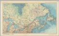
Canada - Ontario, Quebec, and Maritime Provinces. Pergamon World Atlas.
1 : 5000000 Polish Army Topography Service
N. section U.S.
1 : 4200000 Melish, John
British Provinces in Canada.
1 : 7247550 Fisher, Richard Swainson
Partie de l'Amérique septentrionale, qui comprend le cours de l'Ohio, la Nlle. Angleterre, la Nlle York, le New Jersey, la Pensylvanie, le Maryland, la Virginie, la Caroline / par le Sr. Robert de Vaugondy, géographe ordinaire du roi ; M. C. Haussard, fe
from Charts and maps