Maps of Central Lowland

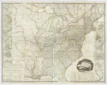
United States of America, 1834 / by H.S. Tanner; engraved by H.S. Tanner, assisted by E.B. Dawson, W. Allen & J. Knight.
from Whole Henry S. Tanner; E. B. Dawson; W. Allen; J. Knight,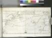
[Map of the North Atlantic Ocean to accompany Jonathan Williams' article on the use of the thermometer in discovering banks, soundings, etc..]; Transactions of the American Philosophical Society.
from Transactions of the American Philosophical Society. American Philosophical Society,
Nova tabula geographica complectens borealiorem Americae partem.
from Charts and maps
L'Amerique Septentrionale 2.
1 : 10050000 Bonne, Rigobert, 1727-1794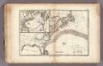
Gulf-Stream.
1 : 15000000 Vincent
Theatre de la guerre presente en Amerique.
from Revolutionary War, 1775-1783
Plate 4: Part of Section 7.
from Atlas of the city of New York, borough of Manhattan / from actual surveys and official plans by George W. and Walter S. Bromley.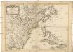
Carte des possessions angloises dans l'Amerique Septentrionale
1 : 3500000 Spojené státy americké-oblast východní Imbert, J. Leopold chez Mondhare
A new and correct map of North America: in which the places of the principal engagements during the present war are accurately inserted / Jno. Lodge sculpt.
from Parts John Lodge,
A Map of the British and French settlements in North America.
from Parts J. (John) Hinton, Newgate Street: [London],
Vereinigte Staaten in Nord America: nach den besten Hülfsmittel verfast / Wien bey T. Mollo.; Lorenz Rieder sc.
from Charts and maps Wien bey; T. Mollo. Lorenz Rieder,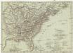
Vereinigte Staaten in Nord America
1 : 10000000 Spojené státy americké-oblast jihovýchodní T. Mollo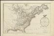
A map of the United States and Canada, New-Scotland, New-Brunswick and New-Foundland = Carte des Etats-Unis, avec le Canada, la Nouvelle Ecosse, le Nouveau Brunswick & Terre-Neuve
1 : 6500000 dressée par Lapie gravé par P. A. F. Tardieu ; écrit par J. J. Pachoux Paris [etc.] : P.A.F. Tardieu [etc.]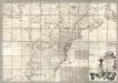
Map of the British and French Dominions in North America.
1 : 2000000 Mitchell, John
United States.
from Whole Published by Thomas & Andrews: [Boston]; Lewis, Samuel,
A new map of North America from the latest discoveries, 1763.
from Charts and maps s.n.: [London],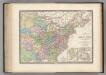
Region Orientale des Etats-Unis, Canada.
1 : 7000000 Levasseur, E.
Carte generale des treize Etats Unis, de l'Amerique septentrionale

A new map of part of the United States of North America : containing those of New York, Vermont, New Hampshire, Massachusets, Connecticut, Rhode Island, Pennsylvania, New Jersey, Delaware, Maryland and Virginia from the latest authorities / by John Cary,
from Parts
A New & accurate map of North America: including the British acquisitions gain'd by the late war, 1763.
from Parts [Printed fr Edward and Charles Dilly, in the Poultry, and John Millan, at Charing-Cross]: [London],
United States.
1 : 9200000 Greenleaf, Jeremiah
United States.
1 : 9250000 Greenleaf, Jeremiah
A new map of part of the United States of North America : containing those of New York, Vermont, New Hampshire, Massachusets, Connecticut, Rhode Island, Pennsylvania, New Jersey, Delaware, Maryland and Virginia from the latest authorities / by John Cary,
from Charts and maps
Die vereinigten Staaten von Nord-America: nach der von Wm. Faden 1783 herausgegebenen Charte, auf welcher alle im englisch americanischen Kriege vorzüglich merkwürdig gewordenen Örter angezeigt, auch die Grenzen zwischen Grosbrittanien, America und Spanien nach Maasgabe des Friedensschulusses von 1783 bestimmt sind / T. Marianus, Sculp., A.V.; Geschichte der Revolution von Nord-America.
from Geschichte der Revolution von Nord-America. Gegel, Ludwig Bernhard Friederich; Sprengel, M. C. (Matthias Christian),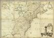
Amerique Septentrionale.
1 : 2000000 Mitchell, John
America Septentrionalis
1 : 1300000 Kanada západní Anville, Jean-Baptiste Bourguinon d' Homannianorum heredum
General-Karte der Vereinigten Staaten von Nord Amerika, nebst den grösst. Theilen von Canada & Tejas : mit Bezeichnung sämmtlicher Cantons, deren Haupt-u. Handelstädte, Eisenbahnen, Kunst- & Hauptstrassen, Canäle etc. etc.
1 : 3200000 nach den neuesten und besten New-Yorker Karten von J. Calvin Smith und H.S. Tanner, sowie nach Berghaus, Länder-& Völkerkunde entw. u. gez. von Albrecht Platt in Stein gest. u. gedr. im geogr. Institut von Albr. Platt ; in Stein gestochen v. Bomsdorf Magdeburg : Kaegelmann
United States.
1 : 10700000 Carey, Mathew
United States.
1 : 10700000 Carey, Mathew