Maps of North Atlantic Ocean

A new chart of the vast Atlantic Ocean: exhibiting the seat of war, both in Europe and America, likewise the trade winds & course of sailing from one continent to the other, with the banks, shoals and rocks drawn according to the latest discoveries, and regulated by astronomical observations / Emanl. Bowen, sculp.
from Atlantic Ocean Emannuel Bowen,
Carte de l'ocean occidental
1 Karte : Kupferdruck ; 31 x 44 cm Bellin Arkstée et Merkus
Carta general del Oceano Atlantico ú ocidental desde 52o de latitud norte hasta el Equador / construida de orden del Rey en el Deposito Hidrografico de Marina y presentada á S.M. por mano del Exmo. Señor D. Antonio Cornel, Secretario de Estado y del Despacho Universal de Guerra, Encargado del de Marina y de la Direccion General de la Real Armada.
from Atlantic Ocean D. Antonio Cornel,
Carte générale de l'océan Atlantique ou Occidental
1 Karte : Kupferdruck ; 59 x 88 cm s.n.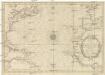
CARTE DE L'OCEAN OCCIDENTAL
1 : 6600000 Atlantský oceán-oblast Bellin, Jacques-Nicolas
Tableau des courants observés dans l'Océan Atlantique Septentrional, au moyen de bouteilles jetées à la mer. / dressé par P. Daussy, ingénieur hydrographe en chef de la Marine; gravé par Michel; écrit par J.M. Hacq.
from Atlantic Ocean P. Daussy; Michel; J.M. Hacq.,
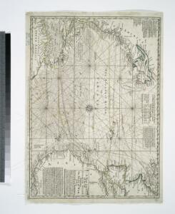
Nieuwe wassende graade zee kaart over de Spaanse Zee vant kanaal tot t'eyland Cuba in Westindia = Nouvelle carte marine reduite de la Mer d. Espagne du canal jusqua Terra Neuf en I. de Cuba dans l'Amerique = The new sea map of the Spannish Zee betwext t' chanell and the I. Cuba / L.v. Anse, schulp.
from Charts and maps L.v. Anse; I. Cuba,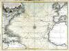
Nouvelle carte de l'ocean Atlantique et théatre de la guerre tant en Europe qu'en Amerique
1 Karte : Kupferdruck ; 52 x 71 cm Denis; Basset; Basset chés Basset rüe St. Jacques au coin de celle des Mathurins à l'image S.te Genevieve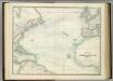
North Atlantic Ocean.
1 : 17500000 Johnston, Alexander Keith
Chart of the Atlantic Ocean.
1 : 43000000 Melish, John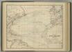
North Atlantic Ocean.
1 : 17500000 Johnston, Alexander Keith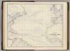
N. Atlantic Ocean.
1 : 19000000 Johnston, Alexander Keith, 1804-1871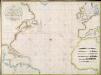
A new chart of the Atlantic or Western Ocean / improved by W. Heather; engraved by J. Stephenson.
from Charts and maps W. Heather; J. Stephenson,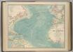
North Atlantic Ocean.
1 : 19000000 Johnston, W. & A.K.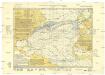
Monatskarte für den Nordatlantischen Ozean
1 : 10700000 Atlantský oceán (oblast) Eckardt & Messtorff
A new chart of the Atlantic or Western Ocean
1 : 9350000 Heather, W. (William) Heather, W. (William)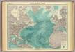
North Atlantic Ocean.
1 : 25000000 John Bartholomew & Co.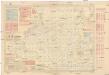
Pilot chart of the North Atlantic Ocean
1 : 14300000 Atlantský oceán (oblast) Maury, Matthew Fontaine Hydrographic Office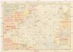
Pilot chart of the North Atlantic Ocean
1 : 14300000 Atlantský oceán (oblast) Maury, Matthew Fontaine Hydrographic Office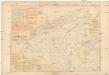
Pilot chart of the North Atlantic Ocean
1 : 14300000 Atlantský oceán (oblast) Maury, Matthew Fontaine Hydrographic Office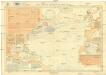
Pilot chart of the North Atlantic Ocean
1 : 11300000 Atlantský oceán (oblast) Hydrographic Office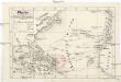
Plavby Krištofa [sic] Kolumba
Atlantský oceán-oblast
A chart of the Atlantic or Western Ocean / drawn from the latest surveys & astronomical observations by J. & A. Walker, London & Liverpool 1830.
from Atlantic Ocean J. & A. Walker,
Mar del nort
1 : 30000000
Chart shewing the tracks across the north Atlantic ocean of don Christopher Columbus
Atlantský oceán Toquet, H. Raban
A new map or chart in Mercators projection, of the Western or Atlantic Ocean, with part of Europe, Africa and America
1 : 18000000
Chart of the Atlantic Ocean: with an illustration of the character and rout[e] of a storm which occurred on the American coast in August 1830 / William Hooker, engraver, New York.
from Atlantic Ocean William Hooker,
Nord-Atlantischer Ocean
Hand-Atlas über alle Theile der Erde und über das Weltgebäude Stieler, Adolf Justus Perthes
Nord-Atlantischer Ocean
Handatlas über alle Theile der Erde und über das Weltgebäude Stieler, Adolf Justus Perthes