Maps of United States

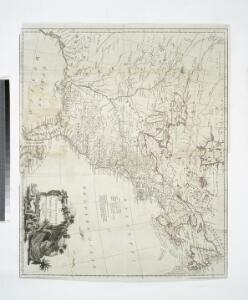
The United States of North America, with the British & Spanish territories according to the treaty / engrav'd by Wm. Faden.
from Whole William Faden,
United States
A new general atlas of modern geography, consisting of a complete collection of maps of the four quarters of the globe Wyld, James James Wyld
The United States of America / B. Tanner, sculpt.
from The American war, from 1775 to 1783, with plans / by Charles Smith.
United States of North America.
1 : 6350000 Faden, William, 1750?-1836
Vereinigte Staaten in Nord America: nach den besten Hülfsmittel verfast / Wien bey T. Mollo.; Lorenz Rieder sc.
from Charts and maps Wien bey; T. Mollo. Lorenz Rieder,
Ètats-Unis de l'Amérique septentrionale avec les Isles Royale, de Terre Neuve, de St. Jean, l'Acadie &c.
from Charts and maps Chez Delamarche, géogr.: Paris; Delamarche, Charles François,
Ètats-Unis de l'Amérique septentrionale avec les Isles Royale, de Terre Neuve, de St. Jean, l'Acadie &c.
from John H. Levine Collection Chez Delamarche, géogr.: Paris; Delamarche, Charles François,
Etats-Unis d'Amerique.
1 : 8000000 Andriveau-Goujon, J.
The United States of North America, with the British & Spanish territories according to the Treaty of 1784 / engrav'd by Wm. Faden, 1785.
from Charts and maps William Faden,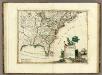
Canada, Le Colonie Inglesi Con La Luigiana, e Florida.
1 : 10000000 Zatta, Antonio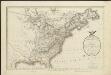
A map of the United States and Canada, New-Scotland, New-Brunswick and New-Foundland = Carte des Etats-Unis, avec le Canada, la Nouvelle Ecosse, le Nouveau Brunswick & Terre-Neuve
1 : 6500000 dressée par Lapie gravé par P. A. F. Tardieu ; écrit par J. J. Pachoux Paris [etc.] : P.A.F. Tardieu [etc.]
The United States of America, showing the boundaries fixed in 1782, five years before the ratification of the Constitution : from a contemporary copy of Benjamin Franklin's red-line map identified in Spain by the Library of Congress at Washington.
1 : 6860480 Facsimile of map published in Paris by Le Rouge and dated 1777. Relief shown pictorially. Inset letters of Aranda and Franklin printed in facsimile reflect the official use of the map in establishing United States boundaries. "Reprinted 1838 by U.S. Geological Survey." Includes text and inset: Nouvelle carte de la Baye dHudson et de Labrador selon las dernieres cartes levées sur les lieux. "This map is one of a series of similar colored maps, depicting the 13 original states from New Hampshire to Georgia at the time of the formation of the Constitution." John, Mitchel, 1711-1768 Washington, D.C. : United States Constitution Sesquicentennial Commission, [Washington, D.C.] : U.S. Geological Survey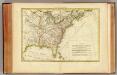
L'Amerique Septentrionale 2.
1 : 10050000 Bonne, Rigobert, 1727-1794
A map of the United States : compiled chiefly from the state maps and other authentic information / by Saml. Lewis, 1809 ; W. [Harrison?] Junr., sculpt.
from Carey's American atlas.
Carte de la Nouvelle France: où se voit le cours des Grandes Rivieres de S. Laurens & de Mississipi, aujour d'hui S. Louïs, aux environs des-quelles se trouvent les etats, païs, nations, peuples &c. de la Floride, de la Louïsiane, de la Virginie, de la Marie-lande, de la Pensilvanie, du Nouveau Jersay, de la Nouvelle Yorck, de la Nouv. Angleterre, de l'Acadie, du Canada, des Esquimaux, des Hurons, des Iroquois, des Ilinois &c., et de la Grande Ile de Terre Neuve / dressée sur les memoires les plus nouveaux recueillis pour l'établissement de la Compagnie françoise occident.
from Charts and maps Chez L'Honoré & Châtelain Libraires?: [Amsterdam?]; Chatelain, Henri Abraham,
A general map of North America : from the latest observations / J. Lodge sculp.
from The Constitutions of the several independent states of America; the Declaration of independence; the Articles of confederation between the said states; the treaties between His Most Christian Majesty and the United States of America. With an appendix, containing an authentic copy of the treaty concluded between Their High Mightinesses the States-General and the United States of America, and the provisional treaty. Pub. by order of Congress. Philadelphia printed. London reprinted, with an advertisement by J.L. de Lolme.
Map of the United States of North America / compiled from the latest and most authentic information by David H. Vance ; engraved by J.H. Young.
from Whole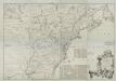
A map of the British and French dominions in North America : with the roads, distances, limits, and extent of the settlements, humbly inscribed to the Right Honourable the Earl of Halifax, and the other Right Honourable the Lords Commissioners for Trade
from Parts
North America from the French of Mr. D'Anville : improved with the back settlements of Virginia and course of Ohio : illustrated with geographical and historical remarks.
from A summary, historical and political, of the first planting, progressive improvements, and present state of the British settlements in North-America ... By William Douglass, M.D. ... Boston, New-England, Printed:
Map Of The United States Of North America.
1 : 2154240 Vance, David H.
New Map of the United States. (Proposal to publish.)
Vance, David H.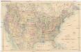
Stanford's General Map of the United States
1 : 5274720 Spojené státy americké Stanford, Edward Edward Stanford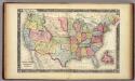
Map Of The United States, And Territories.
1 : 10137600 Mitchell, Samuel Augustus
A new and correct map of the United States ... Upper & Lower Canada ... &c
1 : 4100000 Lewis, Samuel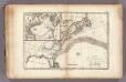
Gulf-Stream.
1 : 15000000 Vincent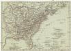
Vereinigte Staaten in Nord America
1 : 10000000 Spojené státy americké-oblast jihovýchodní T. Mollo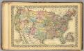
U.S., Canada.
1 : 10000000 Williams, W. (Wellington)
America Septentrionalis. A Map of the British Empire in America.
1 : 11000000 Popple, Henry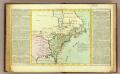
Possessions Francoises.
1 : 12500000 Clouet, J. B. L. (Jean-Baptiste Louis), b. 1730