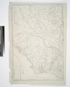
Maps of Piedmont

Carte des Etats-unis : provinces méridionales.
from Parts
A map of Virginia, North and South Carolina, Georgia, Maryland with part of New Jersey &c.
from Parts Printed for R. (Richard) Baldwin in Pater Noster Row: [London] -- Bookseller,
(Canada, Louisiane et Terres Angloises. Southeast section)
1 : 2900000 Anville, Jean Baptiste Bourguignon d, 1697-1782
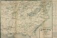
Lloyd's new military map of the border & southern states

Principal cities U.S.
Cornell, S. S. (Sarah S.)
[Die Vereinigten Staaten von Amerika in 6 Blättern, Blatt 6]
Adolf Stieler's Handatlas über alle Theile der Erde und über das Weltgebäude Stieler, Adolf Justus Perthes
[Die Vereinigten Staaten von Nord-Amerika, Blatt 6]
Handatlas über alle Theile der Erde und über das Weltgebäude Stieler, Adolf Justus Perthes
The model war map giving the southern & middle states, with all their water & railroad connections

Lloyd's new military map of the border & southern states
The Model War Map
The Model War Map, giving the Southern and Middle States, with all their Water and Railroad Connections. This map, published by Prang in 1862, shows the eastern coast condensed so that the focus is on the middle states of America from Iowa to Florida. The map shows railway routes, though it is noticeable how many stop before reaching the left hand side of the map, highlighting how railway building across the country was ongoing at the time of the Civil War. The tables on the right hand side of the map detail routes and distances from major cities and towns, 1860 population statistics, the slave population of slave-holding states and the number of men eligible to vote in each state.
Perrine's new topographical war map of the southern states, taken from the latest government surveys and official reports
1 : 2000000 Perrine, Charles O. Perrine, Charles O.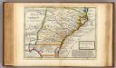
Carolina.
1 : 5500000 Moll, Herman, d. 1732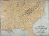
Military Map of the Middle and Southern States
Military Map of the Middle and Southern States, showing the Seat of War during the Great Rebellion in 1861. Drawn and engraved by J. Schedler. This map, published by Schaus, shows the majority of the Confederate states and the Border States of the Union. The map lists the major cities and towns as well as the railroad links across the country.
Lloyd's Map of the Southern States
Lloyd's Map of the Southern States showing all the Railroads, their Stations and Distances, also the Counties, Towns, Villages, Harbors, Rivers & Forts. This map was published by J.T. Lloyd in New York in 1861. It details ‘all the railroads, their stations & distances’, as well as the ‘counties, towns, villages, harbors, rivers and forts’ based on the ‘latest Government and other reliable sources’. The map details states beneath the Mason-Dixon line which theoretically separated the northern and southern states. As well as showing the states that made up the eastern side of the Confederacy, the map also shows the Union states of Kentucky, Maryland and Delaware, which, along with Missouri, made up the Border States. Maintaining these states within the Union was a crucial war aim for Lincoln. J.T. Lloyd
Vereinigte Staaten Von Nord-Amerika In 6 Blattern, Bl. 6.
1 : 3700000 Petermann, A.
War chart of the Southern States showing the towns, rivers, rail-roads and common roads
B.B. Russell & Co.
Balloon View of the Southern States
Balloon View of the Southern States, showing in the foreground the whole territory between Baltimore and St. Louis, and extending towards the horizon to Keywest and New Orleans. This map shows the country between Baltimore, Maryland, and St. Louis, Missouri, with the eastern side of America presented on the left hand side of the map. At the top, in the horizon, the map stretches to Fort Lauderdale, Florida, and New Orleans, Louisiana. An interesting presentation of the country, this map was produced by Louis Prang in 1861 in Boston. Prang published many maps during the American Civil War. According to the description at the bottom of the map, this item was ‘a superior & truthful guide in the present war operations’. L. Prang & Co.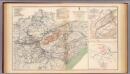
Army of the Cumberland campaigns.
1 : 2200000 United States. War Department
United States of America, southern part.
1 : 2200000 Pinkerton, John, 1758-1826
War Chart of the Southern States.
War Chart of the Southern States. Published in 1862 by B.B. Russell in Boston, War Chart of the Southern States details the cities, towns, rivers, railroads and marked roads in the Confederacy (with the exception of Texas). The portrait at the bottom right of the map is of the Battle of Hampton Roads, which took place over two days in March 1862 off the Virginian coastline. The naval battle was famous for the fight between the USS Monitor, seen in the foreground of the image, and the CSS Merrimac (sometimes referred to as the CSS Virginia due to the fact that it was built from composite parts of Confederate ships). As can be seen in the image, these ships were ‘ironclads’, built with iron and steel armoured plates. Originally a British naval design, the Civil War witnessed the first clash of these ships at the Battle of Hampton Roads, resulting in worldwide attention on this aspect of naval warfare in America. Arguably the battle between the Monitor and Merrimac was the most famous naval event of the conflict and there are numerous contemporary cultural references to the engagement in items produced during the war. The battle itself was inconclusive, although the Union suffered more casualties than their Confederate counterparts. B.B. Russell
United States ... South Eastern States.
1 : 2851200 Fullarton, A. & Co.
The Field of Battle.
The Field of Battle and Prominent US Generals. The Field of Battle and Prominent Union Generals is one of the most picturesque maps in the collection, detailing the main theatres of conflict in the Confederacy, with each state broken up by counties, and surrounded by virtually all of the main Union Army generals that would have been well known to viewers in 1864 when this map was published in New York by Ensign & Bridgman. The generals are mostly all arranged close to the areas where they were conducting operations at the time of the map’s production, for example Generals Grant and Sherman are close to Georgia and South Carolina. Union Navy generals are also pictured, such as General David Farragut who can be seen close to the Georgia coastline. Ensign & Bridgman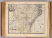
N. & S. Carolina, Georgia &c.
1 : 2900000 Bowen, Emanuel
A map of those parts of Virginia, North Carolina, South Carolina & Georgia which were the scenes of the most important operations of the southern armies
from Parts
Virginiae Item et Floridae Americae Provinciarum, nova Descriptio. [Karte], in: Gerardi Mercatoris Atlas, sive, Cosmographicae meditationes de fabrica mundi et fabricati figura, S. 553.
1 Karte aus Atlas Mercator, Gerhard Montanus, Petrus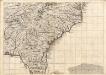
A Map of the British Empire in America. (Sheet 10).
1 : 2000000 Popple, Henry
Nouvelle carte de la Caroline / par R. Morden.; L'Amerique angloise, ou Description des isles et terres du roi d'Angleterre, dans l'Amérique. Avec de nouvelles cartes de chaque isle & terres. Traduit de l'anglois.
from L'Amerique angloise, ou Description des isles et terres du roi d'Angleterre, dans l'Amérique. Avec de nouvelles cartes de chaque isle & terres. Traduit de l'anglois. Blome, Richard,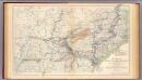
Military map, W.T. Sherman.
1 : 2200000 United States. War Department
The marches of Lord Cornwallis in the Southern Provinces : now States of North America, comprehending the two Carolinas, with Virginia and Maryland, and the Delaware counties / by William Faden, geographer to the King.
from Charts and maps