Maps of Hudson County
Map of New-York Bay and Harbor and the environs / founded upon a trigonometrical survey under the direction of F. R. Hassler, superintendent of the Survey of the Coast of the United States ; triangulation by James Ferguson and Edmund Blunt, assistants ;
from New York harbor
General map of the city of New York, consisting of boroughs of Manhattan, Brooklyn, Bronx, Queens and Richmond : consolidated into one municipality by act of the legislature of the state of New York (Chapter 378 of the laws of 1897) : showing in addition
from Whole
Newark, Elizabeth, the Oranges.
1 : 31680 Vermeule, C. C. (Cornelius Clarkson), 1858-1950
Map of property situated in the 12th ward of the city of New York belonging to the estate of John Taylor : to be sold at auction by Jas. Bleecker & Sons at the Merchts. Exchange at 12 o'clock on Tuesday the 1st April 1834.
from Manhattan
Brooklyn, Vol. 2, Double Page Plate No. 27; Part of Wards 30 & 31, Section 19; [Map bounded by 86th St., 23rd Ave., 24th Ave.; Including Gravesend Bay, 17th Ave.] / by and under the direction of Hugo Ullitz.
From Volume 2.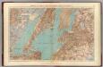
Brooklyn, N.Y. Bay, Jersey City, Hoboken, Bayonne, Newark Bay.
1 : 31680 Vermeule, C. C. (Cornelius Clarkson), 1858-1950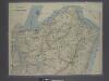
New map of Staten Island
from Staten Island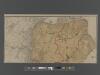
New Standard Map of the Borough of Richmond.
From Staten Island
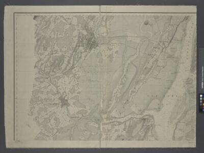
Elizabeth
1 : 24000
Elizabeth
1 : 24000
Elizabeth
1 : 24000
Elizabeth
1 : 24000
Jersey City
1 : 24000
Jersey City
1 : 24000
Elizabeth
1 : 24000
Elizabeth
1 : 24000
Jersey City
1 : 24000
Jersey City
1 : 24000
Elizabeth
1 : 24000
Elizabeth
1 : 24000
Jersey City
1 : 24000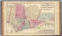
Hoboken, Jersey City.
1 : 19200 Beers, F. W. (Frederick W.)
Jersey City, V. 1, Double Page Plate No. 40 [Map bounded by E. 40th St., New York Bay, E. 21st St.] / compiled under the direction of and published by G.M. Hopkins Co.
From V. 1
Map of the Village of New Brighton, Richmond Co., New York City, NY.
From Staten Island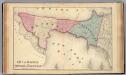
Bayonne; Greenville Twp.
1 : 19200 Beers, F. W. (Frederick W.)
Jersey City, V. 1, Double Page Plate No. 24 [Map bounded by Ocean Ave., Linden Ave., Morris Canal, Avenue C] / compiled under the direction of and published by G.M. Hopkins Co.
From V. 1
New map of that part of the city of New York south from 20th Street on the Hudson & 35th Street on the East River : showing the position of Greenwich, Washington and West Streets on the Hudson River, and Pearl, Water, Front, Cherry & Tompkins Sts. on the
from Manhattan
Topographical atlas of the City of New York / by Egbert L. Viele.
from Topographical atlas of the city of New York, / including the annexed territory showing original water courses and made land / prepared under the direction of Egbert L. Viele.
South Brooklyn, Park Slope, Brooklyn heights, Cobble Hill, Boerum Hill, Carroll Gardens, Red Hook, Gowanus, Windsor Terrace. (cont.)
From District 6