Maps of Hamilton County

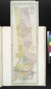
Map of the county of Herkimer / by David H. Burr; engd. by Rawdon, Clark & Co., Albany, & Rawdon, Wright & Co., New York.; An atlas of the state of New York: containing a map of the state and of the several counties / by David H. Burr.
from An atlas of the state of New York : containing a map of the state and of the several counties / by David H. Burr. Burr, David H.; Rawdon, Clark & Co.; Rawdon, Wright & Co.; Stone & Clark Republishers,
Map of the county of Herkimer / by David H. Burr; engd. by Rawdon, Clark & Co., Albany, & Rawdon, Wright & Co., New York.; An atlas of the state of New York, designed for the use of engineers, containing a map of the state and of the several counties. / Projected and drawn ... under the superintendence and direction of Simeon de Witt.
from An atlas of the state of New York, designed for the use of engineers, containing a map of the state and of the several counties. / Projected and drawn ... under the superintendence and direction of Simeon de Witt. Burr, David H.; De Witt, Simeon; Rawdon, Clark & Co.; Rawdon, Wright & Co.; Stone & Clark Republishers,
Map of the county of Herkimer / by David H. Burr; engd. by Rawdon, Clark & Co., Albany, & Rawdon, Wright & Co., New York.; An atlas of the state of New York: containing a map of the state and of the several counties. / Projected and drawn under the superintendence and direction of Simeon de Witt ... And also the physical geography of the State ...
from An atlas of the state of New York : containing a map of the state and of the several counties. / Projected and drawn under the superintendence and direction of Simeon de Witt ... And also the physical geography of the State ... Burr, David H.; De Witt, Simeon,
Warren, Saratoga, Washington counties.
1 : 158400 Bien, Joseph Rudolf
Map of the county of Saratoga / by David H. Burr ; engd. by Rawdon, Clark & Co., Albany, & Rawdon, Wright & Co., N. York.
from An atlas of the state of New York, designed for the use of engineers, containing a map of the state and of the several counties. / Projected and drawn ... under the superintendence and direction of Simeon de Witt.
Map of the county of Saratoga / by David H. Burr ; engd. by Rawdon, Clark & Co., Albany, & Rawdon, Wright & Co., N. York.
from An atlas of the state of New York : containing a map of the state and of the several counties. / Projected and drawn under the superintendence and direction of Simeon de Witt ... And also the physical geography of the State ...
Warren County.
1 : 151000 Burr, David H., 1803-1875
Map of the county of Saratoga / by David H. Burr ; engd. by Rawdon, Clark & Co., Albany, & Rawdon, Wright & Co., N. York.
from An atlas of the state of New York : containing a map of the state and of the several counties / by David H. Burr.
Map of Lake George & vicinity : from recent and careful surveys
1 : 79200 Beers, F. W. (Frederick W.) J.B. Beers & Co.
Map of Saratoga County
from New topographical atlas of Saratoga Co., New York, from actual surveys by S. N. & D. G. Beers and assistants.
Map of the county of Montgomery and Fulton / by David H. Burr ; engd. by Rawdon, Clark & Co., Alby., & Rawdon, Wright & Co., N. York.
from An atlas of the state of New York : containing a map of the state and of the several counties / by David H. Burr.
Washington County.
1 : 151000 Burr, David H., 1803-1875
Map of Lake George
1 : 63360 Stoddard, Seneca Ray, 1844-1917 S. R. Stoddard
Saratoga County.
1 : 151000 Burr, David H., 1803-1875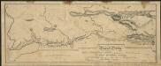
Map and profile of the Champlain Canal as made from Lake Champlain to the Hudson River and surveyed thence to the tide at Waterford
1 : 190080 Geddes, James
Glens Falls
1 : 100000
Glens Falls
1 : 100000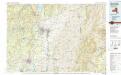
Glens Falls
1 : 100000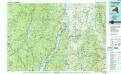
Ticonderoga
1 : 100000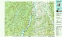
Ticonderoga
1 : 100000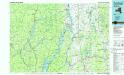
Ticonderoga
1 : 100000
Outline Map of Fulton Co. New York.
from Atlas of Montgomery and Fulton counties, New York. From actual surveys / by and under the direction of B. Nichols ; assisted by H.B. Stranahan ... [et al.]
Map of the county of Montgomery and Fulton / by David H. Burr; engd. by Rawdon, Clark & Co., Alby., & Rawdon, Wright & Co., N. York.; An atlas of the state of New York, designed for the use of engineers, containing a map of the state and of the several counties. / Projected and drawn ... under the superintendence and direction of Simeon de Witt.
from An atlas of the state of New York, designed for the use of engineers, containing a map of the state and of the several counties. / Projected and drawn ... under the superintendence and direction of Simeon de Witt. Burr, David H.; De Witt, Simeon; Rawdon, Clark & Co.; Rawdon, Wright & Co.; Stone & Clark Republishers,
Essex County.
1 : 151000 Burr, David H., 1803-1875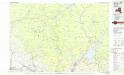
Gloversville
1 : 100000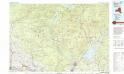
Gloversville
1 : 100000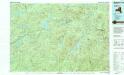
Raquette Lake
1 : 100000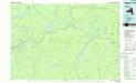
Raquette Lake
1 : 100000
Hamilton County.
1 : 151000 Burr, David H., 1803-1875