Maps of Fire Island

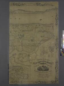
Topographical map of New York City, County and vicinity: showing old farm lines &c. / based on Randells and other official surveys, drawings and modern surveys by J.F. Harrison & T. Magrane; printed by C. Wadlow.
from (A-Z) J. F. Harrison; T. Magrane; C. Wadlow,
Topographical map of New York City, County and vicinity: showing old farm lines &c. / based on Randells and other official surveys, drawings and modern surveys by J.F. Harrison & T. Magrane; printed by C. Wadlow.
from (A-Z) J. F. Harrison; T. Magrane; C. Wadlow,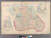
Plate 29: Town of Flushing. - Douglaston. - Bay Side.
from Atlas of Queens Co., Long Island, New York / compiled from official records, private plans & actual surveys by and under the direction of Chester Wolverton.
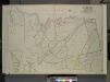
Suffolk County, V. 1, Double Page Plate No. 2 [Map bounded by Town of Smithtown, Bohemia, Nicolls Bay, Great South Bay, Town of Babylon] / supplemented by careful measurements & field observations by our own Corps of Engineers.
From Vol. 1, South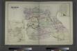
Flushing, Queens Co. L.I. - Douglaston, Town of Flushing, Queens Co. - Hinsdale, Town of Flushing, Kings Co.
from Atlas of Long Island, New York. From recent and actual surveys and records.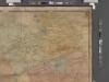
Map of Kings and part of Queens Counties, Long Island, N.Y. / [cartographic material]
From Counties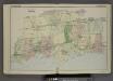
Plan of Town of Islip. [Township]
from Atlas of the towns of Babylon, Islip, and south part of Brookhaven in Suffolk Co., N.Y. Published by Wendelken & Co., 36 Vesey street, New York ... Engraved and printed by L.E. Neuman & Co.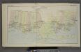
South Part of Brookhaven. [Township]
from Atlas of the towns of Babylon, Islip, and south part of Brookhaven in Suffolk Co., N.Y. Published by Wendelken & Co., 36 Vesey street, New York ... Engraved and printed by L.E. Neuman & Co.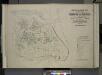
Index map to Vol. 3; Atlas of the Borough of Queens Third Ward city of New York. Published by E. Belcher Hyde; 97 Liberty St., Brooklyn Borough. 1904.
from Third ward: Flushing.
Long I. Sound, Westchester, Queens.
1 : 31680 Vermeule, C. C. (Cornelius Clarkson), 1858-1950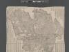
Street Indexed map of the Borough of Queens, also showing the Congressional Districts.
From Queens
Babylon, Suffolk Co. - Commac, Town of Huntington, Suffolk Co.
from Atlas of Long Island, New York. From recent and actual surveys and records.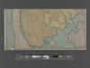
New handy map of the borough of the Bronx.
From Bronx
The Flushing and North Side Railroad, with its leased branches.
from Atlas of Long Island, New York. From recent and actual surveys and records.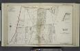
Part of Town of Islip
from Atlas of ... Suffolk County, Long Island, New York ... : based upon actual measurements by our own corps of engineers, maps on file at county offices, also maps from actual surveys furnished by individual owners / under the supervision of Merritt B. Hyde.
Key Continued
From Atlas 137. Vol. 3, 1902.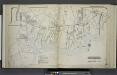
Part of Town of Brookhaven
from Atlas of ... Suffolk County, Long Island, New York ... : based upon actual measurements by our own corps of engineers, maps on file at county offices, also maps from actual surveys furnished by individual owners / under the supervision of Merritt B. Hyde.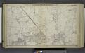
Westbury - Jericho - Hicksville - Locust - Grove, Etc.
from Atlas of Nassau County, Long Island, N.Y. Complete in one volume. Historical, statistical. Based upon maps on file at the county seat in Mineola and upon private plans and surveys furnished by surveyors and individual owners. Supplemented by careful measurements & field observations by our own corps of engineers.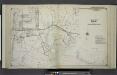
Part of Town of Islip
from Atlas of ... Suffolk County, Long Island, New York ... : based upon actual measurements by our own corps of engineers, maps on file at county offices, also maps from actual surveys furnished by individual owners / under the supervision of Merritt B. Hyde.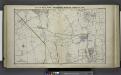
Great Neck Ests. - Manhasset - Roslyn - Mineola, Etc.
from Atlas of Nassau County, Long Island, N.Y. Complete in one volume. Historical, statistical. Based upon maps on file at the county seat in Mineola and upon private plans and surveys furnished by surveyors and individual owners. Supplemented by careful measurements & field observations by our own corps of engineers.
Map of Flushing published by the Flushing United Association. List of references to public buildings.
From Queens
Key Continued
From Atlas 141. Vol. 5, 1903.
Bayside, Auburndale, Oakland Gardens, Little Neck, Douglaston. (cont.)
From District 11
Jackson Heights, North Corona, East Elmhurst. (cont.)
From District 3
Flushing, College Point, Whitestone, Malba, Beechhurst, Bayside, Queensboro Hill, Willets Point. (cont.)
From District 7
Land use policy (cont.)
From District 11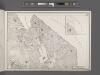
Area District Map Section No. 11
From Area district map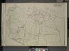
Queens, Vol. 3, Double Page Plate No. 19; Part of ward Three Flushing; [Map bounded by Strongs Causeway Ireland, Mill Road, North Hempstead Turnpike, Crop Road, Union Ave., Hoffman Ave., Boundary Line of Flushing, Jamaica, Head of the Vlei
from Third ward: Flushing.
Key Continued
From Atlas 148, Vol. 10, 1914.