Maps of Buffalo
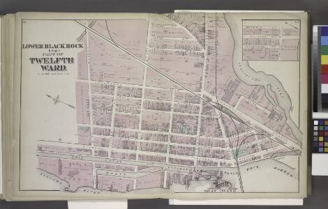
Lower Blackrock being a Part of Twelfth Ward.
from Atlas of the City of Buffalo, Erie Co., New York : from actual surveys & official records.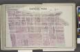
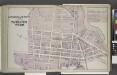
Part of Eleventh Ward.
from Atlas of the City of Buffalo, Erie Co., New York : from actual surveys & official records.
Parts of Eleventh and Twelfth Wards.
from Atlas of the City of Buffalo, Erie Co., New York : from actual surveys & official records.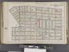
Buffalo, V. 1, Double Page Plate No.17 [Map bounded by Grant St., Forest Ave., Elmwood Ave., Lexington Ave., Massachusetts St., Lawrence Pl.] / engraved by Albert Volk.
From v. 1
Buffalo NW
1 : 24000
Buffalo NW
1 : 24000
Buffalo NW
1 : 24000
Buffalo NW
1 : 24000
Buffalo.
1 : 16000 Rand McNally and Company
"Outline Map of Buffalo, New York."
from Atlas of the City of Buffalo, Erie Co., New York : from actual surveys & official records.
City of Buffalo
from Illustrated historical atlas of Erie Co., New York from actual surveys and records.
Buffalo.
1 : 32000 Rand McNally and Company
Grand Island [Township]; Grand Island Business Directory.
from New topographical atlas of Erie Co., New York, from actual surveys especially for this atlas.
Tonawanda [Township]
from New topographical atlas of Erie Co., New York, from actual surveys especially for this atlas.
Buffalo
1 : 62500
Buffalo
1 : 62500
Buffalo
1 : 62500
Buffalo
1 : 62500
Buffalo
1 : 62500
Buffalo
1 : 62500
Buffalo
1 : 62500
Buffalo
1 : 62500
Buffalo
1 : 62500
Buffalo
1 : 62500
Buffalo
1 : 62500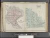
Buffalo, V. 3, Double Page Plate No. 27 [Map of Town of Grand Island, Part of the town of Amherst] / engraved by Albert Volk.
From v. 3
View of the Country round the Falls of Niagara.
1 : 348480 Melish, John
View of the Country round the Falls of Niagara.
1 : 348480 Melish, John
View of the Country round the Falls of Niagara.
1 : 253440 Melish, John