Maps of Westchester County

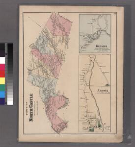
Plate 72: Town of North Castle, Westchester Co. N.Y.
from County atlas of Westchester, New York. Published by J.B. Beers & Co., assisted by S.W. Wilson and others.
Outline map Westchester Co., N.Y.
1 : 109000 Bromley, George Washington; Bromley, Walter Scott; G.W. Bromley & Co.
Map of Westchester Co.
1 : 45000 G.W. Bromley & Co.
Colton's driving & wheeling map of the country twenty five miles north of the city of New York.
1 : 73000 G.W. & C.B. Colton & Co.
Westchester, Double Page Plate No. 30 [Map of Town of Bedford and Somers] / prepared under the direction of Joseph R. Bien, from general surveys and official records.
From Atlas of Westchester County, New York
Westchester, Plate No. 28 [Map of Town of North Castle] / prepared under the direction of Joseph R. Bien, from general surveys and official records.
From Atlas of Westchester County, New York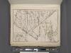
Westchester, Plate No. 29 [Map of Town of New Castle, Village of Mt.Kisco, Village of Chappaqua] / prepared under the direction of Joseph R. Bien, from general surveys and official records.
From Atlas of Westchester County, New York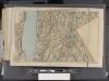
Westchester, Double Page Plate [Map of Westchester County, Irvington, Tarry Town to Sing Sing, East to State Line] / prepared under the direction of Joseph R. Bien, from general surveys and official records.
From Atlas of Westchester County, New York
31. Stamford sheet.
1 : 62500 Geological Survey (U.S.)
Plate 73: Town of Newcastle, Westchester Co. N.Y.
from County atlas of Westchester, New York. Published by J.B. Beers & Co., assisted by S.W. Wilson and others.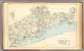
Fairfield Co. S.
1 : 72000 D.H. Hurd & Co.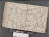
Westchester, Double Page Plate No. 31 [Map of Town of Poundridge, Lewisbord and North Salem] / prepared under the direction of Joseph R. Bien, from general surveys and official records.
From Atlas of Westchester County, New York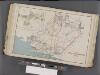
Westchester, Double Page Plate No. 17 [Map of Towns of White Plains, Harrison, and Rye] / prepared under the direction of Joseph R. Bien, from general surveys and official records.
From Atlas of Westchester County, New York
Plaines Blanches et Armees Americaine et Britannique, 12 Octobre1776.
1 : 130000 Marshall, John
Town of Greenwich, Fairfield County, Connecticut.
1 : 38169 Beers, Frederick W.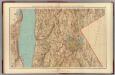
Westchester Co., Irvington-state line.
1 : 31680 Vermeule, C. C. (Cornelius Clarkson), 1858-1950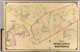
7 North Castle, New Castle.
1 : 18000 Hyde & Company
North part of Town of Mount Pleasant - Pleasantville.
from County atlas of Westchester, New York. Published by J.B. Beers & Co., assisted by S.W. Wilson and others.
Westchester, Double Page Plate No. 20 [Map of town of Greenburg] / prepared under the direction of Joseph R. Bien, from general surveys and official records.
From Atlas of Westchester County, New York
6. Long Id. Sound-Talmadge Hill-Cos Cob-S. Norwalk.
1 : 80000 Servoss, R. D.
Plate 76: Town of Bedford, Westchester Co. N.Y.
from County atlas of Westchester, New York. Published by J.B. Beers & Co., assisted by S.W. Wilson and others.
6. Long Id. Sound-Talmadge Hill-Cos Cob-S. Norwalk.
1 : 80000 Servoss, R. D.
Plate 30: Town of Greenburgh, Westchester Co. N.Y.
from Atlas of New York and vicinity : from actual surveys / by and under the direction of F. W. Beers, assisted by A. B. Prindle & others
8. Kensico-Mt. Kisco-Pleasantville-Bedford.
1 : 80000 Servoss, R. D.
Tarrytown
1 : 62500
Tarrytown
1 : 62500
Tarrytown
1 : 62500
Tarrytown
1 : 62500
Tarrytown
1 : 62500
Tarrytown
1 : 62500
Tarrytown
1 : 62500
Tarrytown
1 : 62500
Tarrytown
1 : 62500