Maps of South America

Map of South America, showing its political divisions ; Map showing the proposed Atrato-inter-oceanic canalroutes, for connecting the Atlantic and Pacific oceans [inset].
from New general atlas.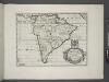
South America.
from A new sett of maps both of antient and present geography : wherein not only the latitude and longitude of many places are corrected according to the latest observations, but also the most remarkable differences of antient and present geography may be quickly discern'd by a bare inspection or comparing of correspondent maps, which seems to be the most natural and easy method to lead young students (for whose use the work is principally intended) unto a competent knowledge of the geographical science : together with a geographical treatise particularly adapted to the use and design of these maps / by Edward Wells, M.A. and student of Christ-Church, Oxon.
Map of Brazil, Bolivia, Paraguay, and Uruguay ; Harbor of Rio Janeiro [inset]; Harbor of Bahia [inset]; Map of Chili ; Island of Juan Fernandez [inset].
from New general atlas.

(Facsimile) America by Martyr.
Martyr, Peter
America [Karte], in: Gerardi Mercatoris Atlas, sive, Cosmographicae meditationes de fabrica mundi et fabricati figura, S. 547.
1 Karte aus Atlas Mercator, Gerhard Montanus, Petrus
Carte Physique de L'Amérique du Sud
1 : 2000000 Description géographique et statistique de la Confédération Argentine Martin de Moussy, Victor Librairie de Firmin Didot frères, fils et Cie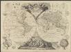
Le globe terrestre divisé en ses deux hémisphères oriental et occidental assujetti aux nouvelles découvertes du XVIIIme siècle
1 : 42700000 par le Sr. Moithey [...] dédié à [...] le Prince de Conty. A Paris : chès Crepy
[Süd-Amerika]
Atlas der Geologie Zittel, K.v. ; Berghaus, Hermann Justus Perthes
218-219. South America, Physical. The World Atlas.
1 : 20000000 USSR (Union of Soviet Socialist Republics).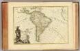
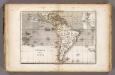
L'Amerique Meridionale.
1 : 31000000 Janvier, Jean
Süd America
Stieler's Hand-Atlas Stieler, Adolf bei Justus Perthes
Ethnographische Karte von Süd-Amerika
Zweiter Band, enthaltend in vier Abtheilungen die Vertheilung der Organismen: 5. Pflanzen-Geographie, 6. Thier-Geographie, 7. Anthropographie, 8. Ethnographie Humboldt, Alexander von Verlag von Justus Perthes
149-50. America Meridionale fisica.
1 : 20000000 Touring club italiano
[Süd-Amerika]
E. von Sydow's Schul-Atlas in sechs und dreissig Karten Sydow, Emil von bei Justus Perthes
221-222. South America, Political. The World Atlas.
1 : 20000000 USSR (Union of Soviet Socialist Republics).
[Neuer Atlas der ganzen Erde nach den neuesten Bestimmungen ... : VI.] Südamerika
Entworfen und gezeichnet von F.W. Streit H. Leutemann sc. Leipzig : J.C. Hinrichs'sche Buchhandlung
South America and the Adjacent Islands.
1 : 3450000 Morse, Jedidiah
A new & exact map of the coast, countries and islands within ye limits of ye South Sea Company, from ye river Aranoca to Terra del Fuego, and from thence through ye South Sea, to ye north part of California &c. with a view of the general and coasting ...
1 : 32000000
Bu harita, büyük Türk denizcisi Piri reis tarasindam 1513 tarihinde yapilmis olan ve Topkapi Müzesinde bulunan aslindan alinarak basilmistir
Atlantský oceán-oblast Devlet Basimevi
L'Amerique Meridionale divisée en ses principales parties
1 : 16000000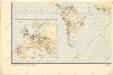
Hospodářská mapa světa - těžba nerostných surovin
Vents (Amerique)
1 : 50000000 Vincent
Jižní Amerika

Süd-America
Schul-Atlas über alle Theile der Erde nach dem neuesten Zustande, und über das Weltgebäude Stieler, Adolf Justus Perthes
Amérique septentrionale et méridionale
1 Karte auf 4 Blatt : Kupferdruck ; 96 x 110 cm Robert de Vaugondy; Arrivet chés l'auteur quai de l'horloge du Palais près le Pont-neuf
A map of South America containing Tierra-Firma, Guayana, New Granada, Amazonia, Brasil, Peru, Paraguay, Chaco, Tucuman, Chili and Patagonia / from Mr. D'Anville with several improvements and additions and the newest discoveries
1 Mapa, col. Anville, J.B. d' ; Laurie & Whittle published by Laurie & Whittle as the Act directs
Jižní Amerika
1 : 48260000 Jižní Amerika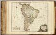
Amerique Meridionale.
1 : 17400000 Robert de Vaugondy, Gilles, 1688-1766
![Map of South America, showing its political divisions ; Map showing the proposed Atrato-inter-oceanic canalroutes, for connecting the Atlantic and Pacific oceans [inset].](https://images-2.georeferencer.com/images/iiif/599126683615/full/,300/0/native.jpg)

