Maps of Great Lakes

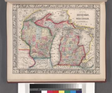
County map of Michigan, and Wisconsin.
from Mitchell's new general atlas, containing maps of the various countries of the world, plans of cities, etc., embraced in fifty-three quarto maps., forming a series of eighty four maps and plans, together with valuable statistical tables.
Canada, Louisiane et Terres Angloises. (Northwest section)
1 : 2900000 Anville, Jean Baptiste Bourguignon d, 1697-1782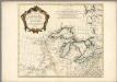
Partie occidentale du Canada et septentrionale de la Louisiane avec une partie de la Pensilvanie
1 : 3000000 Anville, Jean Baptiste Bourguignon d', 1697-1782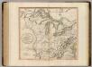
Western Terr., Kentucky, Pennsylvania, etc.
1 : 3300000 Cary, John, ca. 1754-1835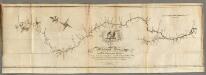
Map of the Mississippi River from its Source to the Mouth of the Missouri.
1 : 1584000 Pike, Zebulon Montgomery
Plan of Captain Carvers Travels in the interior Parts of North America.
1 : 2851200 Carver, Jonathan
Upper Territories of the United States.
1 : 2060000 Carey, Mathew
Upper Territories of the United States.
1 : 3700000 Carey, Mathew
134-35. Mich., Wis., Minn., Ia., Mo., Ill., Ind., Ky.
1 : 3000000 Touring club italiano
U.S. West of Mississippi R. 3.
1 : 2000000 Freyhold, Edward; Warren, Gouverneur Kemble, 1830-1882; United States. Army. Corps of Engineers
A new and general map of the middle dominions belonging to the United States of America: viz. Virginia, Maryland, the Delaware-counties, Pennsylvania, New Jersey &c. with the addition of New York, & of the greatest part of New England &c as also of the bordering parts of the British possessions in Canada.
from Parts Published by Laurie & Whittle, No. 53 Fleet Street ...: London; Robert Laurie and James Whittle,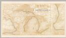
Northern Steamship Co. (map)
1 : 4752000 Northern Steamship Company
Upper Territories of the the United States.
1 : 5900000 Lucas, Fielding Jr.
N.W. Territory.
1 : 8553600 Scott, Joseph
Sheet 1: United States of Nth. America.
1 : 1584000 Tardieu, P.F.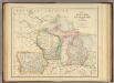
States of Michigan, Wisconsin and Iowa.
1 : 3453120 Rogers, Henry Darwin
Lay's map of the United States / compiled from the latest and best authorities and actual surveys by Amos Lay, geographer and map publisher ; engraved by O.H. & D.S. Throop & Wm. Chapin.
From Whole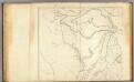
United States 3.
1 : 1750000 Arrowsmith, Aaron
200-201. United States of America, North East Central. The World Atlas.
1 : 2500000 USSR (Union of Soviet Socialist Republics).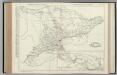
Ontario.
Rand McNally and Company
N. W. Territory.
1 : 8236800 Carey, Mathew
Michigan, Wisconsin, Iowa, & Minnesota.
1 : 3200000 Black, Adam & Charles
North Western and MichiganTerritories.
1 : 4400000 Lucas, Fielding Jr.
Guide through Ohio, Michigan, Indiana, Illinois, Missouri, Wisconsin & Iowa : showing the township lines of the United States Surveys, location of cities, towns, villages, post hamlets, canals, rail and stage roads / by J. Calvin Smith ; engr. by S. Stiles, Sherman & Smith
1 : 2200000 Annotatie: Gerestaureerd en op Japans papier geplakt; Met statistische gegevens m.b.t. bevolking, landbouw en veeteelt, industrie en openbare financiën J. Calvin Smith; S. Stiles, Sherman & Smith New York, [N.Y.] : J.H. Colton & Co.
PARTIE OCCIDENTALE de la NOUVELLE FRANCE ou du CANADA
1 : 3600000 Velká kanadská jezera (Kanada a Spojené státy americké) Bellin, Jacques-Nicolas par le Heritiers de Homan
PARTIE OCCIDENTALE de la NOUVELLE FRANCE ou du CANADA
1 : 3600000 Velká kanadská jezera (Kanada a Spojené státy americké) Bellin, Jacques-Nicolas par les Heritiers de Homan
PARTIE OCCIDENTALE de la NOUVELLE FRANCE ou du CANADA
1 : 3600000 Velká kanadská jezera (Kanada a Spojené státy americké) Bellin, Jacques-Nicolas par les Heritiers de Homan
United States ... North Central Section.
1 : 2851200 Fullarton, A. & Co.
Western states, territories.
1 : 6400000 Grigg, John