Maps of Piedmont

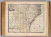
County map of North Carolina, Map of South Carolina, County map of Florida ; Map of Charleston Harbor [inset].
from New general atlas.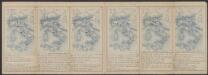
Virginiae Item et Floridae Americae Provinciarum, nova Descriptio. [Karte], in: Gerardi Mercatoris Atlas, sive, Cosmographicae meditationes de fabrica mundi et fabricati figura, S. 553.
1 Karte aus Atlas Mercator, Gerhard Montanus, Petrus
VIRGINIÆ | partis australis, | et FLORIDÆ partis | orientalis, interjacentiumque regionum | NOVA DESCRIPTIO.
[Amsterdam : Joan Blaeu]
N. & S. Carolina, Georgia &c.
1 : 2900000 Bowen, Emanuel
Virginiae partis australis, et Floridae partis orientalis, interjacentiumque regionum Nova Descriptio. [Karte], in: Theatrum orbis terrarum, sive, Atlas novus, Bd. 2, S. 330.
1 Karte aus Atlas Blaeu, Joan Blaeu, Willem Janszoon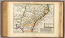
Carolina.
1 : 5500000 Moll, Herman, d. 1732
Virginiae partis australis, et Floridae partis orientalis, interiacentiumque regionum Nova Descriptio. [Karte], in: Le théâtre du monde, ou, Nouvel atlas contenant les chartes et descriptions de tous les païs de la terre, Bd. 2, S. 321.
1 Karte aus Atlas Blaeu, Willem Janszoon und Blaeu, Joan Blaeu, Willem Janszoon
Virginiae partis australis, et Floridae partis orientalis, interjacentiumque regionum Nova Descriptio. [Karte], in: Novus atlas absolutissimus, Bd. 6, S. 210.
1 Karte aus Atlas Janssonius Offizin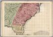
A Map of the British Empire in America. (Sheet 10).
1 : 2000000 Popple, Henry
Virginiae partis australis, et Floridae partis orientalis, interjacentiumq[ue] regionum, nova descriptio.
from John H. Levine Collection Meurs, Jacob van; Montanus, Arnoldus,
Virginiae partis australis, et Floridae partis orientalis, interjacentiumq[ue] regionum nova descriptio.
from Parts J. and C. Blaeu: [Amsterdam]; Blaeu, Joan; Blaeu, Willem Janszoon,
Virginiae partis australis et Floridae partis orientalis interjacentimq[ue] regionum, nova descriptio.
from Charts and maps Ioannem Ianssonium?: [Amstelodami?]; Jansson, Jan,
Virginiae partis australis, et Floridae partis orientalis, interjacentiumq[ue] regionum nova descriptio.
from Parts J. and C. Blaeu: [Amsterdam]; Blaeu, Joan; Blaeu, Willem Janszoon,
Virginiae partis australis, et Floridae partis orientalis, interjacentiumq[ue] regionum nova descriptio.
from John H. Levine Collection J. and C. Blaeu: [Amsterdam]; Blaeu, Joan; Blaeu, Willem Janszoon,
Virginiae partis australis, et Floridae partis orientalis, interjacentiumq[ue] regionum nova descriptio.
from Charts and maps J. and C. Blaeu: [Amsterdam]; Blaeu, Joan; Blaeu, Willem Janszoon,
Virginiae partis australis, et Floridae partis orientalis, interjacentiumq[ue] regionum nova descriptio.
from Parts J. and C. Blaeu: [Amsterdam]; Blaeu, Joan; Blaeu, Willem Janszoon,
Nouvelle carte de la Caroline / par R. Morden.; L'Amerique angloise, ou Description des isles et terres du roi d'Angleterre, dans l'Amérique. Avec de nouvelles cartes de chaque isle & terres. Traduit de l'anglois.
from L'Amerique angloise, ou Description des isles et terres du roi d'Angleterre, dans l'Amérique. Avec de nouvelles cartes de chaque isle & terres. Traduit de l'anglois. Blome, Richard,
Virginiae partis australis, et Floridae partis orientalis, interiacentiumque regionum Nova Descriptio. [Karte], in: Novus Atlas, das ist, Weltbeschreibung, Bd. 2, S. 328.
1 Karte aus Atlas Blaeu, Joan Blaeu, Willem Janszoon
Pas Kaart Van de Kust von Carolina
1 : 1749000 Color print. This is a hydrographic chart of part of the Virginia and North Carolina coast. Covers Atlantic states. Depths shown by soundings. Oriented with north to right. Shows lines of orientation (rhumb lines). Includes one inset [ca. 1:380,000]: "De Kust van Carolina Tusschen Riviers Mondt en C. de S. Romano in't Groodt." Keulen, Johannes van, fl. 1726-1753.
The marches of Lord Cornwallis in the Southern Provinces : now States of North America, comprehending the two Carolinas, with Virginia and Maryland, and the Delaware counties / by William Faden, geographer to the King.
from Charts and maps
Carte general de la Caroline: dresse sur les memoires le plus nouveaux
1 : 1300000 Published in N. Sanson's "Atlas Nouveau Contenant Toutes Les Parties du Monde", Paris, 1696, based on the 1685 Thornton-Morden-Lea map. Relief shown pictorially. Depths shown by soundings. Prime meridian: [Cadiz]. Includes inset [scale ca. 1:203,000] of the Ashley and Cooper Rivers, including Charles Town. Sanson, Nicolas, 1600-1667.;Mortier, Pierre. chez Pierre Mortier
Carte General De La Caroline. [Karte] [Charles Towne, Flüsse Cooper und Ashley] [Nebenkarte], in: Atlas nouveau, contenant toutes les parties du monde [...], Bd. 2, S. 245.
1 Karte aus Atlas Sanson, Nicolas Jaillot, Alexis Hubert und Mortier, Pieter
A map of Virginia and Maryland.
from Parts
North Carolina. South Carolina.
1 : 2012000 Gray, Ormando Willis
North Carolina, South Carolina, Georgia and Eastern Tennessee

North Carolina, South Carolina, Georgia and Eastern Tenessee

North Carolina, South Carolina, Georgia.
1 : 1788000 Finley, Anthony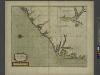
A new mapp of CAROLINA
from The sea-atlas : containing an hydrographical description of most of the sea-coasts of the known parts of the world.
![County map of North Carolina, Map of South Carolina, County map of Florida ; Map of Charleston Harbor [inset].](https://images-2.georeferencer.com/images/iiif/625657798622/full/,300/0/native.jpg)

