Maps of Brazil

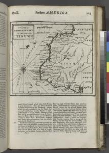
Brasil, divided into its captainships.
from New & accurate description of the earth in all its empires, kingdoms and states
Jižní Amerika
1 : 48260000 Jižní Amerika
L'Amerique meridionale
1 : 1
Brasilia
from America: being the latest, and most accurate description of the Nevv vvorld; containing the original of the inhabitants, and the remarkable voyages thither. The conquest of the vast empires of Mexico and Peru, and other large provinces and territories, with the several European plantations in those parts. Also their cities, fortresses, towns, temples, mountains, and rivers. Their habits, customs, manners, and religions. Their plants, beasts, birds, and serpents. With an appendix, containing, besides several other considerable additions, a brief survey of what hath been discover'd of the vnknown south-land and the Arctick region. Collected from most authentick authors, augmented with later observations, and adorn'd with maps and sculptures, by John Ogilby ...
Facsimile: Part of South America by de Vaugondy.
1 : 17500000 de Vaugondy, Robert
A new map of South America, shewing it's general divisions, chief cities & towns, rivers, mountains &c.
1 : 23000000
Süd America
1 : 16570000 Jižní Amerika Friedel, Johann Liechtenstern, Joseph Marx von im Verlage des Kunst u. Industrie Comptoirs
Facsimile Part of America by Delisle.
1 : 65000000 L'Isle, Guillaume de, 1675-1726
Americae pars meridionalis
1 : 1
South America With Improvements To 1823.
1 : 11088000 Tanner, Henry S.
South America : with improvements to 1825
1 : 11000000 Tanner, Henry Schenck, 1786-1858 H.S. Tanner
A map of Brazil, now called New Portugal.
from Carey's general atlas, improved and enlarged : being a collection of maps of the world and quarters, their principal empires, kingdoms, &c.
Facsimile: Part of South America by Sanson.
1 : 26500000 Sanson D'Abbeville, N.
Americae Pars Meridionalis [Karte], in: Novus atlas absolutissimus, Bd. 6, S. 226.
1 Karte aus Atlas Janssonius Offizin
Brasil
2 mapes. Datat al s. XIX. Gras y compañia, editores. Madrid
Americae pars meridionalis
Jižní Amerika Janssonius, Johannes sumptibus Ioannis Ianßony
[Karte von Süd-Amerika zur Übersicht der Unebenheiten des Bodens]
Erster Band, enthaltend in vier Abtheilungen die Erscheinungen der anorganischen Natur: 1. Meteorologie und Klimatographie. 2. Hydrologie und Hydrographie. 3. Geologie. 4. Tellurischer Magnetismus Humboldt, Alexander von Verlag von Justus Perthes
Carte de L'Amerique Meridionale.
1 : 24000000 Vivien de St Martin, L.
Descripcion de las Yndias del Mediodia
Fueron pocos los mapas sobre América que se imprimieron en España durante los siglos XVI y XVII. La censura de la corona sobre toda información geoestratégica del Nuevo Mundo impidió que muchos mapas manuscritos de exploradores, navegantes y cosmógrafos al servicio de la corona fueran considerados secretos de Estado. Durante el siglo XVI los pocos mapas de América que fueron autorizados por la corona española a ser difundidos fueron impresos en los Países Bajos, entonces bajo dominio de España. Luego de la muerte del rey Felipe II de España en 1598, su hijo Felipe III decidió flexibilizar un poco la censura oficial y publicar parte de los conocimientos oficiales españoles sobre el Nuevo Mundo para contrarrestar las versiones antiespañolas que sobre la conquista de América circulaban en diferentes obras, como Les Grands Voyages de Theodore de Bry. En este contexto es que Antonio de Herrera y Tordesillas, Cronista Mayor de Indias, publica algunos mapas de América elaborados por su antecesor el Cronista y Cosmógrafo Mayor de Indias, Juan López de Velasco, para un informe administrativo al Consejo de Indias. Los mapas de López de Velasco eran ideales para ilustrar las el relato oficial español de los hechos de la conquista de América en las Décadas, ya que no incluían demasiados detalles geográficos, mostrando más bien las unidades territoriales de administración españoles de América, tal y como estas eran narradas en las Décadas. La versión impresa en Ámsterdam de estos mapas se identifica por ser de menor tamaño que la original. El interés de los neerlandeses por los territorios españoles de América se inscribe en el marco de la “Guerra de Flandes” o “Guerra de los Ochenta años” (1568-1548). En la década de 1620 las Provincias Unidas de los Países Bajos apoyaron la actividad de corsarios neerlandeses para que éstos atacaran las rutas mercantiles ibéricas con el Nuevo Mundo y apoyaron distintos planes para la toma de posesión de distintos territorios españoles y portugueses en América. Herrera y Tordesillas, Antonio de (1549-1626) López de Velasco, Juan (1530-1598) Colijn, Michiel
South America.
1 : 20000000 Andree, Richard; Times (London, England)
Süd-America
Atlas der Pflanzengeographie über alle Theile der Erde Rudolphi, Ludwig Verlag der Nicolaischen Buchhandlung
Süd-America's Bergsysteme und Stromgebiete
Grosser Hand-Atlas über alle Theile der Erde in 170 Karten Meyer, J. Verlag des Bibliographischen Instituts
Carte de L'Amérique du Sud divisée en ses différents états
1 : 2000000 Description géographique et statistique de la Confédération Argentine Martin de Moussy, Victor Librairie de Firmin Didot frères, fils et Cie
South America.
1 : 34000000 Huntington, Nathaniel G. (Nathaniel Gilbert), 1785-1848
South America.
1 : 22176000 Colton, G.W.
Composite: South America.
1 : 10500000 Cary, John, ca. 1754-1835
Süd America
Schul-Atlas in 36 Karten Völter, Daniel Verlag der J.M. Dannheimer'schen Buchhandlung
Süd Amerika
1 : 28539000 Jižní Amerika Schlieben Gleditsch
Amerique Meridionale en 1840.
1 : 32000000 Houze, Antoine Philippe