Maps of Pontic Steppe

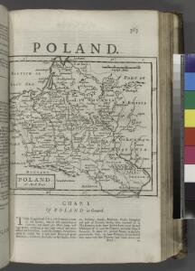
Poland.
from New & accurate description of the earth in all its empires, kingdoms and states
Osteuropa beim Regierungsantritte Peters des Gr. 1682
Osteuropa Peter I., Russland, Zar
Osteuropa beim Regierungsantritte Peters des Gr. 1682
Osteuropa Peter I., Russland, Zar
Osteuropa um das Jahr 1250
Osteuropa
Osteuropa um das Jahr 1250
Osteuropa
Karta razselenija [sic] Slavjan v IX stol
1 : 12600000 Evropa východní Kočubinskij, Aleksandr Aleksandrovič C.I. Mal'cov
Composite: Sheets 1 - 16 Kriegsstrassen Karte eines Theiles von Russland
1 : 1400000 Schubert, Friedrich Theodor
20. Nord u. Ost-Europa im Jahre 1310
Nordeuropa, Osteuropa
Sarmatia.
1 : 22000000 Fenner, Rest.
Russland um das Jahr 962
1 : 21000000 Russland
Slovanský zeměvid
Evropa Šafařík, Pavel Josef Merklas, Václav
Slovanský zeměvid
Evropa Šafařík, Pavel Josef Merklas, Václav
Slovanský zeměvid
1 : 4530000 Evropa Šafařík, Pavel Josef Merklas, Václav
Slovanský zeměvid
Evropa Šafařík, Pavel Josef Merklas, Václav
Slovanský zeměvid
Evropa Šafařík, Pavel Josef Merklas, Václav
Slovanský zeměvid
Evropa Šafařík, Pavel Josef Merklas, Václav
Slovanský zeměvid
Evropa Šafařík, Pavel Josef Merklas, Václav
Slovanský zeměvid
Evropa Šafařík, Pavel Josef Merklas, Václav
Slovanský zeměvid
1 : 4530000 Evropa Šafařík, Pavel Josef Merklas, Václav
Slovanský zeměvid
1 : 4530000 Evropa Šafařík, Pavel Josef Merklas, Václav
Slovanský zeměvid
1 : 4530000 Evropa Šafařík, Pavel Josef Merklas, Václav
Slovanský zeměvid
Evropa Šafařík, Pavel Josef Merklas, Václav
Slovanský zeměvid
Evropa Šafařík, Pavel Josef Merklas, Václav
Slovanský zeměvid
Evropa Šafařík, Pavel Josef Merklas, Václav
Slovanský zeměvid
Evropa Šafařík, Pavel Josef Merklas, Václav
[Střední a východní Evropa]
Evropa střední
[Střední a východní Evropa]
Evropa střední
Tabula Europae VIII. [Karte], in: Geographia universalis vetus et nova complectens Claudii Ptolemaei Alexandrini enarrationis libros VIII, S. 245.
1 Karte aus Atlas Münster, Sebastian [und Ptolemaeus, Claudius]
Ukraine - Franken : heutige administrative Grenzen
Ukraine, Franken, Verwaltungsgliederung Scheidig, Holger