Maps of Adirondack Mountains

The provinces of New York, and New Jersey : with part of Pensilvania, and the governments of Trois Rivieres, and Montreal / drawn by Capt. Holland ; engraved by Thomas Jefferys, geographer to His Majesty.
from Parts
The provinces of New York, and New Jersey : with part of Pensilvania, and the governments of Trois Rivieres, and Montreal / drawn by Capt. Holland ; engraved by Thomas Jefferys, geographer to His Majesty.
from Parts
Map of the District Of Montreal, Lower Canada.
1 : 174240 Wyld, James, 1812-1887
(Canada, Louisiane et Terres Angloises. Southeast section) Le Fleuve Saint-Laurent.
1 : 910000 Anville, Jean Baptiste Bourguignon d, 1697-1782
Survey of the several routes for a rail road from Ogdensburgh to Lake Champlain : made in pursuance of an act of the State of New York, passed May 14th, 1840 / by Edw H. Brodhead, chief engineer ; J.H. Jackson, H. Thomas & V. Whitney, commissrs.
from (A-Z)
Ontario No. 2.
1 : 1110000 Rand McNally and Company
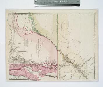
A new and accurate map of the province of New York and part of the Jerseys, New England and Canada: shewing the scenes of our military operations during the present war: also the new erected state of Vermont / Jn. Lodge, sculp.
from (A-Z) John Lodge,,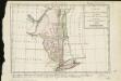
Carte de la Nouvelle York, y-compris les terres cédées du N. Hamp-Shire, sous le nom d'etat de Vermont
1 : 2500000 Hilliard d'Auberteuil, Michel René
New York (western and northern sections).
1 : 570000 Rand McNally and Company
A new and accurate map of the province of New York and part of the Jerseys, New England and Canada, shewing the scenes of our military operations during the present war, also the new erected state of Vermont
Northern Part of the State Of New York
1 : 443529 Lay, Amos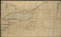
Map of the northern part of the state of New York
1 : 450000 Lay, Amos
Shell Highway Map of New York (western portion).
1 : 792000 Shell Oil Company
Province de New-York : en 4 feuilles / par Montrésor.
from (A-Z)
Map exhibiting the Farmington & Hampshire & Hampden canals : together wth the line of their proposed continuation through the valley of the Connecticut River to Canada / engraved and published by N. & S.S. Jocelyn.
from Parts
Map of the county of Montgomery / by David H. Burr ; engd. by Rawdon, Clark & Co., Alby., & Rawdon, Wright & Co., N. York.
from An atlas of the state of New York : containing a map of the state and of the several counties. / Projected and drawn under the superintendence and direction of Simeon de Witt ... And also the physical geography of the State ...
New York.
1 : 614000 Hammond, C.S.
Vermont : from actual survey
1 : 700000 Doolittle, Amos, 1754-1832 Mathew Carey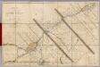
Seat of War in Lower Canada.
1 : 443520 Lay, Amos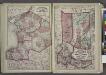
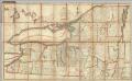
"Jefferson, Oswego, and Lewis Counties"
from New topographical atlas and gazetteer of New York, comprising a topographical view of the several counties of the state, ... including ... map of the United States and territories ... Compiled from the latest astronomical observations, official surveys and records of the United States and territories ...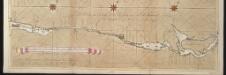
La riviere de Canada ou de St. Laurens de I. de Montreal jusqu'à le lac Ontario aux Nord de l'Amérique
Canada Gerard van Keulen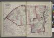
"St. Lawrence, Franklin, Clinton, and Essex"
from New topographical atlas and gazetteer of New York, comprising a topographical view of the several counties of the state, ... including ... map of the United States and territories ... Compiled from the latest astronomical observations, official surveys and records of the United States and territories ...
An improved map of Vermont : compiled from the latest authorities
1 : 450000 Robinson, Lewis, 1793-1871 Lewis Robinson
An improved map of Vermont : compiled from the latest authorities
1 : 450000 Robinson, Lewis, 1793-1871 Lewis Robinson
A correct map of the State of Vermont, from actual survey : exhibiting the county and town lines, rivers, lakes, ponds, mountains, meetinghouses, mills, public roads, &c
1 : 240000 Whitelaw, James, 1748-1829 [s.n.]
Watertown. [Township]
from New topographical atlas of Jefferson Co., New York : From actual surveys / by S.N. & D.G. Beers and assistants.
A correct map of the State of Vermont, from actual survey : exhibiting the county and town lines, rivers, lakes, ponds, mountains, meetinghouses, mills, public roads, &c
1 : 245000 Whitelaw, James, 1748-1829 James Whitelaw
State of Vermont Drawn and Engraved.
1 : 1393920 Scott, Joseph
Hamilton County.
from Atlas of New York.