Maps of West Herzegovina

Imotski und Macarsca.
from Spezialkarte der osterreichisch-ungarischen Monarchie.
Skize der Gegend bey Imoschi
1 : 92439 Imotski, Umland Jabornigg von Altenfels, Rudolf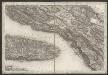
[Kanal von Brač]
Kroatien Dalmatien Brač Umland
[Grenzgebiet der Gespanschaft Split-Dalmatien ; Höhentabelle]
Kroatien Dalmatien Bezirk Split-Dalmatien Umland
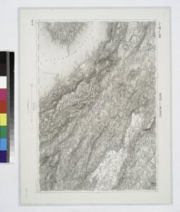
Zupanjac und Cista.
from Spezialkarte der osterreichisch-ungarischen Monarchie.
Ravca und Zastrazisce.; Spezialkarte der osterreichisch-ungarischen Monarchie.
from Spezialkarte der osterreichisch-ungarischen Monarchie. Austro-Hungarian Monarchy. Militärgeographisches Institut.,
Charte des sudöstlichen Theiles von Dalmatien mit dem Oesterreichischen Antheile von Albanien
1 : 540000 Albánie Kipferling, Karl Joseph
Charte des sudöstlichen Theiles von Dalmatien mit dem oesterreichischen Antheile von Albanien
Albánie im Verlage des Kunst und Industrie Comptoirs
Partie de la Dalmatie du sud est avec l'Albanie
Albánie im Verlage des Kunst und Industrie Comptoirs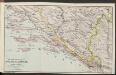
Die adriatische Küste von Spalato bis Cattaro
1 : 900000 Kroatien Adriaküste
Skelet-Karte für Curs-Skizzen
Chorvatsko K. u. k. Kriegs-Marine
Střední Dalmacie
1 : 750000 Dalmácie střední (Chorvatsko) Machát, František c. a k. voj. zeměpisný ústav
Mostar
1 : 200000 Mostar (Bosna a Hercegovina) Kartografska radionica
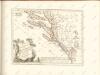
Oestlicher Theil von Dalmatien
1 : 445000 Chorvatsko Santini, P. Engelman, J. W. F. A. Schraembl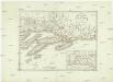
Oestlicher Theil von Dalmatien
1 : 450000 Chorvatsko Santini, P. Engelman, J. W. F. A. Schraembl
Generalkarte von Zentraleuropa

Adriatisches Meer, Küstenkarte
1 : 180000 Hvar (Chorvatsko : ostrov) Oesterreicher, Tobias von Hydrographisches Amt der k. u. k. Kriegs-Marine
[Generalkarte von Bosnien und der Hercegovina]
1 : 300000 Bosnien-Herzegowina Herzegowina
Kocerin und Mostar.
from Spezialkarte der osterreichisch-ungarischen Monarchie.
Almissa und S. Pietro Della Brazza.
from Spezialkarte der osterreichisch-ungarischen Monarchie.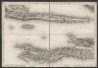
[Kanal von Korčula]
Kroatien Dalmatien Korčula Umland
Lesina.
from Spezialkarte der osterreichisch-ungarischen Monarchie.
Ljubuski und Metkovic.
from Spezialkarte der osterreichisch-ungarischen Monarchie.
Sinj und Spalato.
from Spezialkarte der osterreichisch-ungarischen Monarchie.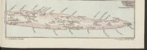
Lesina [Osthälfte]
1 : 200000 Kroatien Hvar
[Skizze von Ljubuški]
Bosnien-Herzegowina Ljubuški Skizze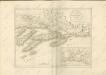

Eisenbahnkarte der k.u.k. oesterreichisch-ungarischen Monarchie

Ragusa, Mostar
1 : 750000 Dubrovník (Chorvatsko : oblast) Nimmerfroh, J. K. u. k. Militärgeographisches Institut
Ragusa, Mostar
1 : 750000 Dubrovník (Chorvatsko : oblast) K. u. k. militär-geografisches Institut