Maps of Herzegovina-Neretva Canton

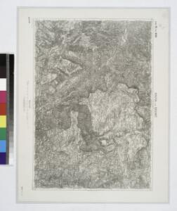
Konjica und Bjelemic.; Spezialkarte der osterreichisch-ungarischen Monarchie.
from Spezialkarte der osterreichisch-ungarischen Monarchie. Austro-Hungarian Monarchy. Militärgeographisches Institut.,
Railway-System in South-Dalmatia and in South-Eastern Herzegovina
Kroatien Dalmatien
Generalkarte von Zentraleuropa

Sarajevo.
Sarajevo (Bosna a Hercegovina) Blumtritt, H. Oesfeld, C. W. K. k. militär. geografisches Institut
Hercegovina
1 : 400000 Hercegovina Daneš, Jiří Viktor Královská česká společnost nauk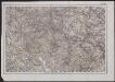
[Generalkarte von Bosnien und der Hercegovina] K. 11. Bosna Seraj (Mostar)
1 : 300000 Bosnien-Herzegowina Herzegowina
Ragusa, Mostar
1 : 750000 Dubrovník (Chorvatsko : oblast) Nimmerfroh, J. K. u. k. Militärgeographisches Institut
Ragusa, Mostar
1 : 750000 Dubrovník (Chorvatsko : oblast) K. u. k. militär-geografisches Institut
Ragusa, Mostar
1 : 750000 Dubrovník (Chorvatsko : oblast) K. k. militär-geographisches Institut
Reg. Bosniae
1 : 875000 Mollova mapová sbírka Bruggen, Johann van der Brugge, Johannes van der
Reg. Bosniae
1 : 875000 Mollova mapová sbírka Pfeffel, Johann Andreas Pfeffel, Johann Andreas I.
Dalmatien und seine Hinterländer
1 : 1700000 Kroatien Dalmatien Bosnien Herzegowina
Übersichtskarte von Mittel - Europa

Sheet XVIII: Karte Des Oesterreichischen Kaiserstaates.
1 : 576000 Scheda, Josef
Dalmatien und Montenegro
Kroatien, Montenegro
XVIII, uit: General-Karte des oesterreichischen Kaiserstaates mit einem grossen Theile der angrenzenden Länder / durch Josef Scheda ... bearb. und hrsg
1 : 576000 Annotatie geografische gegevens: Maatstokken: oesterreichische Meilen, geografische oder deutsche Meilen, preussische Meilen, türkische Berri, französische Lieues, russische Werste; Maatstok per blad: wiener Klafter, öster. Meilen; Blad XIX: statistische en taalkundige informatie; Blad XIX: legenda [Wien : K.K. Militärisch-Geografisches Institut]
General-Karte des gesammten Insurrections-Gebietes in Bosnien der Hercegovina und Süd-Dalmatien nebst den angrenzenden Ländern Montenegro, Novi-Bazar u. Serbien
1 : 420000 Bosna A. Hartleben's Verlag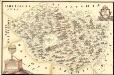
Mapa Particvlaris Regni Bosniae
Mollova mapová sbírka Geyer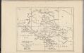
Montenegro
Montenegro
Das Königreich Bosnia
1 : 1570000 Bosna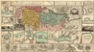
Regnum Bosniae, una cum finitimis Croatiae, Dalmatiae, Slavoniae, Hung. et Serviae partibus praecipuorum in his regionibus munimentorum ichnographia Curantibus
1 : 840000 Mollova mapová sbírka Ötinger, Johann Homann, Johann Baptista - dědici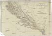
Oestreichisch Dalmatien und Albanien
1 : 930000 Albánie Mollo, Tranquillo Tranquillo Mollo
Oestreichisch Dalmatien und Albanien
1 : 930000 Albánie Mollo, Tranquillo Tranquillo Mollo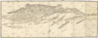
Carte von Dalmatien und dem Gebieth von Ragusa
1 : 180000 Dalmácie (Chorvatsko) Traux, Maximilian de Artaria und Compagnie
Strassen- und Eisenbahnkarte des oesterreichischen Kaiserthumes
1 : 864000 Blatt 15 Schaller, G. K.K. Militärisch-Geografisches Institut, Karten-Evidenthaltungs-Abteilung
Bosnia & Hercegovina
Bosna a Hercegovina Jordán, J. P. J.P. Jordán
Dalmatien und Montenegro nach den ostreichishen Vermessungen mit Verbesserungen
1 : 750000 Dalmácie (Chorvatsko) Wilkinson, John Gardner Mayer, Gustav Gustav Mayer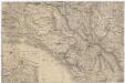
[Montenegro und angrenzende Länder]
Bělehrad (Srbsko : oblast)
Republik Bosnien-Herzegowina. Katasterkarte: Bosniaken-Muslime
Bosnien-Herzegowina Bosnier, Grundeigentum