Maps of Sinaia

Sinaia.
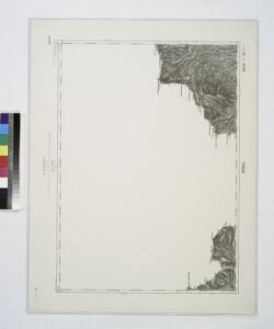
from Spezialkarte der osterreichisch-ungarischen Monarchie.
Sinaia : provisorisch
1 : 75000 Sinaia Geripp: Techn. Aspir. J. Kempter u. Fwbl. J. Malzner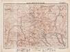
Lambert-Cholesky sheet 4055 (Vârful Neamţului)
1 : 20000 Romanian military topographic map sheet under Lambert-Cholensky projection Institutul Geografic Militar geo-spatial.org Institutul Geografic Militar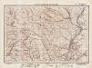
Lambert-Cholesky sheet 4054 (Muntele Baiul)
1 : 20000 Romanian military topographic map sheet under Lambert-Cholensky projection Direcția Topografică Militară geo-spatial.org Direcția Topografică Militară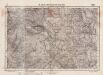
Lambert-Cholesky sheet 4053 (Teşila)
1 : 20000 Romanian military topographic map sheet under Lambert-Cholensky projection Serviciul Geografic al Armatei geo-spatial.org Serviciul Geografic al Armatei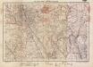
Lambert-Cholesky sheet 4052 (Comarnic)
1 : 20000 Romanian military topographic map sheet under Lambert-Cholensky projection Institutul Geografic Militar geo-spatial.org Institutul Geografic Militar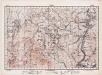
Lambert-Cholesky sheet 3955 (Predeal)
1 : 20000 Romanian military topographic map sheet under Lambert-Cholensky projection Direcția Topografică Militară geo-spatial.org Direcția Topografică Militară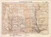
Lambert-Cholesky sheet 3954 (Buşteni)
1 : 20000 Romanian military topographic map sheet under Lambert-Cholensky projection Direcția Topografică Militară geo-spatial.org Direcția Topografică Militară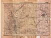
Lambert-Cholesky sheet 3952 (Pietroșița)
1 : 20000 Romanian military topographic map sheet under Lambert-Cholensky projection Institutul Geografic Militar geo-spatial.org Institutul Geografic Militar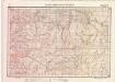
Lambert-Cholesky sheet 3854 (Moeciul de Sus)
1 : 20000 Romanian military topographic map sheet under Lambert-Cholensky projection Serviciul Geografic al Armatei geo-spatial.org Serviciul Geografic al Armatei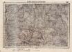
Lambert-Cholesky sheet 3852 (Pucheni)
1 : 20000 Romanian military topographic map sheet under Lambert-Cholensky projection Serviciul Geografic al Armatei geo-spatial.org Serviciul Geografic al Armatei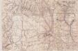
Lambert-Cholesky sheet 4152 ()
1 : 20000 Romanian military topographic map sheet under Lambert-Cholensky projection Neprecizat geo-spatial.org Neprecizat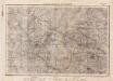
Lambert-Cholesky sheet 4153 (Schiuleşti)
1 : 20000 Romanian military topographic map sheet under Lambert-Cholensky projection Direcția Topografică Militară geo-spatial.org Direcția Topografică Militară
Brasso [Kronstadt].
from Spezialkarte der osterreichisch-ungarischen Monarchie.
Torzburger Pass.
from Spezialkarte der osterreichisch-ungarischen Monarchie.
Maršrut ot mon. Predjala do g. Kronštadta
1 : 42300 Brašov (Rumunsko) Beketov, V.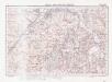
Lambert-Cholesky sheet 4056 (Satulunug)
1 : 20000 Romanian military topographic map sheet under Lambert-Cholensky projection Institutul Geografic Militar geo-spatial.org Institutul Geografic Militar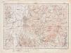
Lambert-Cholesky sheet 3956 (Rîșnov)
1 : 20000 Romanian military topographic map sheet under Lambert-Cholensky projection Direcția Topografică Militară geo-spatial.org Direcția Topografică Militară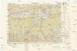
Osteuropa 1:300 000
1 : 300000 Brašov-oblast (Rumunsko) OKH
Gebiet um Kronstadt
1 : 600000 Braşov, Kronstadt (Siebenbürgen, Region)
Generalkarte von Zentraleuropa
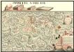
Plan der Batalie bei Beroschan in der Walachai samt den Drei Mahlichen Stvrm den 26. Jvli 1739
Mollova mapová sbírka Geyer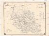
Harta cailor de comunicatie din Judetul Prahova
1 : 200000 Rumunsko Ministerul Lucrărilor Publice
Harta Cailor de Comunicatie din Jud. Dambovita
1 : 200000 Rumänien Dâmbovit̜a
Harta Cailor de Comunicatie din Judetul Prahova
Rumänien Prahova Verkehrsweg
Volksverteilung des Burzenlandes
1 : 300000 Burzenland ethnische Gruppe
Harta Cailor de Comunicatie din Judetul Muscel
Rumänien Muşcel
Übersichtskarte vom Gebiet der Sektion "Kronstadt" des Siebenbürgischen Karpatenvereines
1 : 150000 Brašov (Rumunsko : oblast) Myszisch S. K. V.
Brassó (Kronstadt)
1 : 75000 Brașov Geripp: J. Schwarz u. Offiz. J. Stumpf. Terrain: Rittm. E. Freih. v. Vecsey u. C. A. Scotti