Maps of Vâlcea

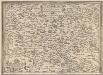
Calinesci.
from Spezialkarte der osterreichisch-ungarischen Monarchie.
Călinescĭ
1 : 75000 Judeţ Argeş Geripp: J. Richter. Terrain: Rittm. C. Rit. v. L[...]
Situations Plan von dem Rothenthurner Pasz oder sogennanten Carolinschen Weege
Sibiu-oblast (Rumunsko) Fáborský, Jan B. Nipočić, Vasilij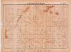
Lambert-Cholesky sheet 3252 (Băile Olănești)
1 : 20000 Romanian military topographic map sheet under Lambert-Cholensky projection Institutul Geografic Militar geo-spatial.org Institutul Geografic Militar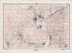
Lambert-Cholesky sheet 3352 (Jiblea)
1 : 20000 Romanian military topographic map sheet under Lambert-Cholensky projection Direcția Topografică Militară geo-spatial.org Direcția Topografică Militară
Maršrut ot Rotenturmskago Karantina do s. Kineni
1 : 18000 Fagarašské hory (Rumunsko) Beketov, V.
Harta Cailor de Comunicatie din Jud. R. Valcea
Rumänien Vâlcea
Verestorony [Rothenthurm-Pasz].
from Spezialkarte der osterreichisch-ungarischen Monarchie.
Petroseny.
from Spezialkarte der osterreichisch-ungarischen Monarchie.
Verestorony (Rothenthurm - Pasz)
1 : 75000 Südkarpaten Pass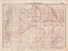
Lambert-Cholesky sheet 3356 (Vâraful Păului)
1 : 20000 Romanian military topographic map sheet under Lambert-Cholensky projection Direcția Topografică Militară geo-spatial.org Direcția Topografică Militară
Gebiet um Hermannstadt
1 : 600000 Hermannstadt, Hermannstadt (Region)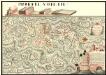
Plan der Batalie bei Beroschan in der Walachai samt den Drei Mahlichen Stvrm den 26. Jvli 1739
Mollova mapová sbírka Geyer
Harta Cailor de Comunicatie din Judetul Argesu
Rumänien Judeţ Argeş Verkehrsweg
Petroseny
1 : 75000 Petroșani Geripp: J. Richter. Terrain: Oberlt. R. Bayer
Felek [Freck].
from Spezialkarte der osterreichisch-ungarischen Monarchie.
Riul Sebes.
from Spezialkarte der osterreichisch-ungarischen Monarchie.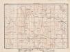
Lambert-Cholesky sheet 3251 (Stoenești)
1 : 20000 Romanian military topographic map sheet under Lambert-Cholensky projection Direcția Topografică Militară geo-spatial.org Direcția Topografică Militară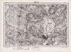
Lambert-Cholesky sheet 3351 (Râmnicul Vâlcea)
1 : 20000 Romanian military topographic map sheet under Lambert-Cholensky projection Direcția Topografică Militară geo-spatial.org Direcția Topografică Militară
Carte de la Roumanie et pays limitrophes. Bukarest
1 : 500000 France. Service géographique de l'armée [Paris] : Service géographique de l'armée
Sheet XV: Karte Des Oesterreichischen Kaiserstaates.
1 : 576000 Scheda, Josef
Nagyszeben (Hermannstadt), Brassó (Kronstadt), Bukarest, Craiova, Vidin, Rusčuk
1 : 750000 Brašov (Rumunsko : oblast) Korb, L. K. u. k. Militärgeographisches Institut
Hermannstadt, Kronstadt, Bukarest, Craiova, Vidin, Rusčuk
1 : 750000 Brašov (Rumunsko : oblast) K. k. militär-geographisches Institut
Generalkarte Von Siebenbürgen. Nach geometrisch gemessenen Karten und andern zuverlaessigen Hilfsmitteln verjüngt, und graduirt von Herrn A. von Wenzely. Herausgegeben von Herrn F. A. Schraembl
1 : 430000 Siebenbürgen Produkt, Straßennetz Wenzely, Anton; Schraembl, Franz Anton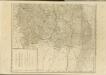

Übersichtskarte von Mittel - Europa

XV, uit: General-Karte des oesterreichischen Kaiserstaates mit einem grossen Theile der angrenzenden Länder / durch Josef Scheda ... bearb. und hrsg
1 : 576000 Annotatie geografische gegevens: Maatstokken: oesterreichische Meilen, geografische oder deutsche Meilen, preussische Meilen, türkische Berri, französische Lieues, russische Werste; Maatstok per blad: wiener Klafter, öster. Meilen; Blad XIX: statistische en taalkundige informatie; Blad XIX: legenda [Wien : K.K. Militärisch-Geografisches Institut]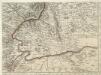
Augustissimo Romanor. Imperatori Iosepho I. Hungaria Regi Invictissimo Mappam Hanc Regni Hungariae
1 : 540000 Mollova mapová sbírka Müller, Johann Christoph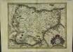
Transylvania
1 Karte : Kupferdruck ; 32 x 41 cm Mercator; Hondius excusum apud Henricum Hondium sub insigno atlantis