Maps of Hunedoara

Vulkan Pasz.
from Spezialkarte der osterreichisch-ungarischen Monarchie.
Parosiu und Vulkan - Pass
1 : 75000 Vulcan Pass
Carte des Sieges der K.K. Truppen unter Com.do des F.Z. Fürsten v. Hohenlohe am Vulkan Pass über 1
1 Karte : Kupferdruck ; 12 x 17 cm [Trattner]
Lambert-Cholesky sheet 2655 (Coroeşti)
1 : 20000 Romanian military topographic map sheet under Lambert-Cholensky projection Institutul Geografic Militar geo-spatial.org Institutul Geografic Militar
Lambert-Cholesky sheet 2755 (Barul Mare)
1 : 20000 Romanian military topographic map sheet under Lambert-Cholensky projection Institutul Geografic Militar geo-spatial.org Institutul Geografic Militar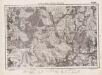
Lambert-Cholesky sheet 2554 (Retezat)
1 : 20000 Romanian military topographic map sheet under Lambert-Cholensky projection Institutul Geografic Militar geo-spatial.org Institutul Geografic Militar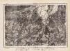
Lambert-Cholesky sheet 2555 (Clopotiva)
1 : 20000 Romanian military topographic map sheet under Lambert-Cholensky projection Direcția Topografică Militară geo-spatial.org Direcția Topografică Militară
Lambert-Cholesky sheet 2855 (Petrila)
1 : 20000 Romanian military topographic map sheet under Lambert-Cholensky projection Institutul Geografic Militar geo-spatial.org Institutul Geografic Militar
Malomviz
1 : 25000 Kendeffy, Malomvizi
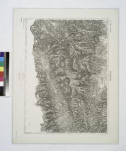
Petroseny.
from Spezialkarte der osterreichisch-ungarischen Monarchie.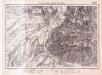
Lambert-Cholesky sheet 2656 (Haţeg)
1 : 20000 Romanian military topographic map sheet under Lambert-Cholensky projection Institutul Geografic Militar geo-spatial.org Institutul Geografic Militar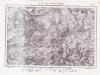
Lambert-Cholesky sheet 2756 (Cioclovina)
1 : 20000 Romanian military topographic map sheet under Lambert-Cholensky projection Institutul Geografic Militar geo-spatial.org Institutul Geografic Militar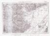
Lambert-Cholesky sheet 2556 (Demsusi)
1 : 20000 Romanian military topographic map sheet under Lambert-Cholensky projection Institutul Geografic Militar geo-spatial.org Institutul Geografic Militar
Harta Cailor de Comunicatie din Judetul Gorjiu
Rumänien Gorj Verkehrsweg
Süd-Ost-Ungarn
1 : 600000 Österreich-Ungarn (Südost), Banat
Hátszeg
1 : 75000 Haţeg Geripp: L. Lützenburger. Terrain: Hptm. Brantner
Hatszeg.; Spezialkarte der osterreichisch-ungarischen Monarchie.
from Spezialkarte der osterreichisch-ungarischen Monarchie. Austro-Hungarian Monarchy. Militärgeographisches Institut.,
Borlova und Klopotiva.; Spezialkarte der osterreichisch-ungarischen Monarchie.
from Spezialkarte der osterreichisch-ungarischen Monarchie. Austro-Hungarian Monarchy. Militärgeographisches Institut.,
Borló und Klopotiva
1 : 75000 Caraş-Severin Geripp: F. Kohout. Terrain: Oberlt. Sachs
Petroseny
1 : 75000 Petroșani Geripp: J. Richter. Terrain: Oberlt. R. Bayer
Riul Sebes.
from Spezialkarte der osterreichisch-ungarischen Monarchie.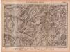
Lambert-Cholesky sheet 2856 (Rovinel)
1 : 20000 Romanian military topographic map sheet under Lambert-Cholensky projection Institutul Geografic Militar geo-spatial.org Institutul Geografic Militar
Kornyareva.; Spezialkarte der osterreichisch-ungarischen Monarchie.
from Spezialkarte der osterreichisch-ungarischen Monarchie. Austro-Hungarian Monarchy. Militärgeographisches Institut.,
Somosréve
1 : 75000 Caraş-Severin Geripp: F. Kohout. Terrain: Feldw. Maschka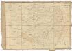
Carte von Temescher Banat
1 : 220000 Banát Péchy von Péchyujfalu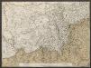
Temeschwarer Bannat. Nach denen neuesten Anzeigen
Temescher Banat, Osmanisches Reich
Generalkarte Von Siebenbürgen. Nach geometrisch gemessenen Karten und andern zuverlaessigen Hilfsmitteln verjüngt, und graduirt von Herrn A. von Wenzely. Herausgegeben von Herrn F. A. Schraembl
1 : 430000 Siebenbürgen Produkt, Straßennetz Wenzely, Anton; Schraembl, Franz Anton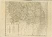

Übersichtskarte von Mittel - Europa