Maps of Koper

Cittanuova und Montona.
from Spezialkarte der osterreichisch-ungarischen Monarchie.
Istrien
Istrijský poloostrov (Slovinsko a Chorvatsko) Mach, G. Hydrographisches Amt der K. u. k. Kriegsmarine, Seekarten-Depot
Istrien
1 : 60000 Istrijský poloostrov (Slovinsko a Chorvatsko) Oesterreicher, T. Hydrographisches Amt der K. u. k. Kriegs-Marine, Seekarten-Depot
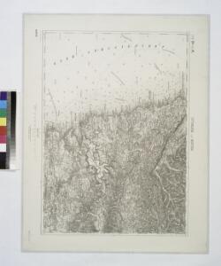
Italy 1:100,000 / Sardinia 1:100,000, Trieste
Italy 1:100,000 / Sardinia 1:100,000 , Series GSGS 4164. Great Britain. War Office. General Staff. Geographical Section. [London] : War Office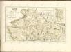

Triest.
from Spezialkarte der osterreichisch-ungarischen Monarchie.
Parenzo und Rovigno.
from Spezialkarte der osterreichisch-ungarischen Monarchie.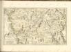
Ducatus Carnioliae Tabula Chorographica Iusu Sumptuque inclytorum Provinciae Statuum.
1 : 100000 Mollova mapová sbírka Florjančič de Grienfeld, Janez Dizma
Pinguent und Volosca.
from Spezialkarte der osterreichisch-ungarischen Monarchie.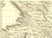
Ducatus Carnioliae Tabula Chorographica Iusu Sumptuque inclytorum Provinciae Statuum.
1 : 100000 Mollova mapová sbírka Florjančič de Grienfeld, Janez Dizma
Carta idrografica del golfo di Trieste
1 : 160500
Istrien
1 : 60000 Istrijský poloostrov (Slovinsko a Chorvatsko) Oesterreicher, T. Hydrographisches Amt der K. u. k. Kriegsmarine, Seekartendepot
Bez titulu: Triest

Zone 23, Kol. IX, Triest, uit: Geologische Karte der im Reichsrathe vertretenen Königreiche und Länder der Österreich-Ungarischen Monarchie : auf Grundlage der Specialkarte i.M. 1:75.000 des k.u.k. Militär-geographischen Institutes / neu bearb. und als Kartenwerk von 341 Blattnummern in zwanglosen Lfg. hrsg. durch die k.k. Geologische Reichsanstalt in Wien
1 : 75000 titelvariant: Geologische Spezialkarte der im Reichsrate vertretenen Königreiche und Länder der Österreichisch-Ungarischen Monarchie; Geologische Specialkarte der im Reichsrathe vertretenen Königreiche und Länder der Österreichisch-Ungarischen Monarchie; Annotatie: Titel bovenaan kaartblad: Geologische Spezialkarte der im Reichsrate vertretenen Königreiche und Länder der Österreichisch-Ungarischen Monarchie en Geologische Specialkarte der im Reichsrathe vertretenen Königreiche und Länder der Österreichisch-Ungarischen Monarchie; Annotatie geografische gegevens: Coördinaten gebaseerd op nulmeridiaan van Ferro (Hierro) Kaiserlich-Königliche Geologische Reichsanstalt, Wenen Wien : K.K. Geologische Reichsanstalt
Adriatisches Meer, Küstenkarte
1 : 180000 Istrijský poloostrov (Slovinsko a Chorvatsko) Oesterreicher, Tobias von Hydrographisches Amt der k. u. k. Kriegsmarine
Adriatisches Meer, Küsten-Karte
1 : 180000 Istrijský poloostrov (Slovinsko a Chorvatsko) Oesterreicher, Tobias von Hydrographisches Amt der k. u. k. Kriegs-Marine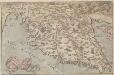
Histriae tabula
Istrien Coppo. Pietro
Istria olim Iapidia [Karte], in: Le théâtre du monde, ou, Nouvel atlas contenant les chartes et descriptions de tous les païs de la terre, Bd. 3, S. 155.
1 Karte aus Atlas Blaeu, Willem Janszoon und Blaeu, Joan Blaeu, Willem Janszoon
Istria olim Iapidia [Karte], in: Theatrum orbis terrarum, sive, Atlas novus, Bd. 3, S. 131.
1 Karte aus Atlas Blaeu, Joan Blaeu, Willem Janszoon
Istria olim Iapidia [Karte], in: Novus Atlas, das ist, Weltbeschreibung, Bd. 3, S. 151.
1 Karte aus Atlas Blaeu, Joan Blaeu, Willem Janszoon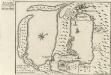
Buccari samt dessen Seehafen und derer tieffen in Istrien am Adriatischen Meer gelegen dem Kayser gehörig
Mollova mapová sbírka Bodenehr, Gabriel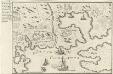
Accurater Plan des Kayserliche freyen See-Hafen Fiume oder S. Veit am Flaun, an den Grentzen des Hertzogthus Crain und des Oesterreichischen Istrien am Golfo di Carnero, und am Einfluss des Flusses Fiume
Mollova mapová sbírka Bodenehr, Gabriel
Carta del litorale Austriaco
1 : 440000 Istrijský poloostrov (Slovinsko a Chorvatsko) Schwarzer, Ernesto de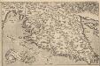
Histriae tabula [Karte], in: Theatrum orbis terrarum, S. 357.
1 Karte aus Atlas Ortelius, Abraham Vrients, Jan Baptista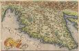
Histriae tabula [Karte], in: Theatrum orbis terrarum, S. 262.
1 Karte aus Atlas Ortelius, Abraham
Istria, olim Lapidia. [Karte], in: Novus atlas absolutissimus, Bd. 5, S. 65.
1 Karte aus Atlas Janssonius Offizin
Istrie
1 : 750000 Machát, František c. a k. voj. zeměpisný ústav
Carnioia
Mollova mapová sbírka Hoffmann, Johannes Hoffmann, Johann