Maps of Buzau

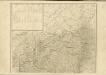
Nerejul.
from Spezialkarte der osterreichisch-ungarischen Monarchie.
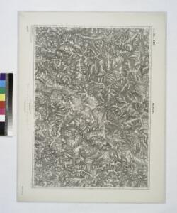
Nerejul
1 : 75000 Nereju Geripp: Feldw. J. Jakubec. Terrain: Assist. O. Tuschell
Lambert-Cholesky sheet 4558 (Nereju)
1 : 20000 Romanian military topographic map sheet under Lambert-Cholensky projection Serviciul Geografic al Armatei geo-spatial.org Serviciul Geografic al Armatei
Lambert-Cholesky sheet 4557 (Vintileasca)
1 : 20000 Romanian military topographic map sheet under Lambert-Cholensky projection Serviciul Geografic al Armatei geo-spatial.org Serviciul Geografic al Armatei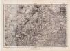
Lambert-Cholesky sheet 4556 (Bisoca)
1 : 20000 Romanian military topographic map sheet under Lambert-Cholensky projection Serviciul Geografic al Armatei geo-spatial.org Serviciul Geografic al Armatei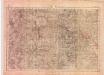
Lambert-Cholesky sheet 4555 (Lopătari)
1 : 20000 Romanian military topographic map sheet under Lambert-Cholensky projection Serviciul Geografic al Armatei geo-spatial.org Serviciul Geografic al Armatei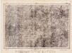
Lambert-Cholesky sheet 4455 (Brăești)
1 : 20000 Romanian military topographic map sheet under Lambert-Cholensky projection Direcția Topografică Militară geo-spatial.org Direcția Topografică Militară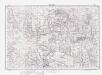
Lambert-Cholesky sheet 4656 (Dumitreşti)
1 : 20000 Romanian military topographic map sheet under Lambert-Cholensky projection Direcția Topografică Militară geo-spatial.org Direcția Topografică Militară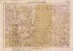
Lambert-Cholesky sheet 4658 (Mera)
1 : 20000 Romanian military topographic map sheet under Lambert-Cholensky projection Serviciul Geografic al Armatei geo-spatial.org Serviciul Geografic al Armatei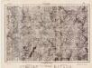
Lambert-Cholesky sheet 4356 (Cheia-Crasnei)
1 : 20000 Romanian military topographic map sheet under Lambert-Cholensky projection Direcția Topografică Militară geo-spatial.org Direcția Topografică Militară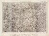
Lambert-Cholesky sheet 4355 (Gura-Siriului)
1 : 20000 Romanian military topographic map sheet under Lambert-Cholensky projection Direcția Topografică Militară geo-spatial.org Direcția Topografică Militară
Putna-Patak.
from Spezialkarte der osterreichisch-ungarischen Monarchie.
Magyarbodza.
from Spezialkarte der osterreichisch-ungarischen Monarchie.
Carte des glücklichen Treffens am Bozaner Pass unter Com.do des F.M.L. Fürsten Hohenlohe den 3ten
1 Karte : Kupferdruck ; 12 x 17 cm [Trattner]
Putna-Patak
1 : 75000 Putna, Judet Suceava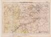
Lambert-Cholesky sheet 4559 (Vasuiu)
1 : 20000 Romanian military topographic map sheet under Lambert-Cholensky projection Serviciul Geografic al Armatei geo-spatial.org Serviciul Geografic al Armatei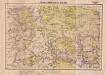
Lambert-Cholesky sheet 4659 (Stroeşti)
1 : 20000 Romanian military topographic map sheet under Lambert-Cholensky projection Serviciul Geografic al Armatei geo-spatial.org Serviciul Geografic al Armatei
Harta Cailor de Comunicatie din Judetul Buzeu
Rumänien Buzău
Gebiet um Kronstadt
1 : 600000 Braşov, Kronstadt (Siebenbürgen, Region)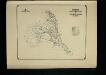
Harta Cailor de Comunicatie din Judetul Putna
Rumänien Putna Verkehrsweg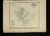
Harta Cailor de Comunicatie din Judetul Romnicu-Sarat
1 : 200000 Rumänien Rîmnicu Sărat Verkehrsweg
Magyarbodza
1 : 75000 Județ Covasna Geripp: L. Lützenburger. Terrain: Offiz. J. Le Gay Edl. v. Lierfels
Lambert-Cholesky sheet 4454 (Boziorul)
1 : 20000 Romanian military topographic map sheet under Lambert-Cholensky projection Direcția Topografică Militară geo-spatial.org Direcția Topografică Militară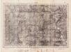
Lambert-Cholesky sheet 4354 (Păltineni)
1 : 20000 Romanian military topographic map sheet under Lambert-Cholensky projection Direcția Topografică Militară geo-spatial.org Direcția Topografică Militară
Lambert-Cholesky sheet 4554 (Grabicina de Jos)
1 : 20000 Romanian military topographic map sheet under Lambert-Cholensky projection Neprecizat geo-spatial.org Neprecizat
[Střední Rumunsko]
1 : 420600 Rumunsko Schraembl, Franz Anton F.A. Schraembl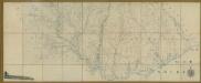
Carte de la Moldavie
1 : 330000 Moldawien, Bessarabien
Generalkarte Von Siebenbürgen. Nach geometrisch gemessenen Karten und andern zuverlaessigen Hilfsmitteln verjüngt, und graduirt von Herrn A. von Wenzely. Herausgegeben von Herrn F. A. Schraembl
1 : 430000 Siebenbürgen Produkt, Straßennetz Wenzely, Anton; Schraembl, Franz Anton
Bez titulu: Šest listů speciálních map Ukrajiny