Maps of Timișoara

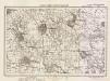
Otelek und Szephely.
from Spezialkarte der osterreichisch-ungarischen Monarchie.
Ótelek und Széphely
1 : 75000 Timiş Geripp: Fwkr. Acham. Terrain: Oberlt. Peraković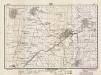
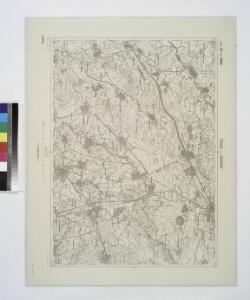
Lambert-Cholesky sheet 1558 (Cenei)
1 : 20000 Romanian military topographic map sheet under Lambert-Cholensky projection Direcția Topografică Militară geo-spatial.org Direcția Topografică Militară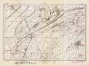
Lambert-Cholesky sheet 1557 (Uivar)
1 : 20000 Romanian military topographic map sheet under Lambert-Cholensky projection Direcția Topografică Militară geo-spatial.org Direcția Topografică Militară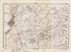
Lambert-Cholesky sheet 1556 (Ivanda)
1 : 20000 Romanian military topographic map sheet under Lambert-Cholensky projection Direcția Topografică Militară geo-spatial.org Direcția Topografică Militară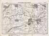
Lambert-Cholesky sheet 1658 (Sânmihaiul Român)
1 : 20000 Romanian military topographic map sheet under Lambert-Cholensky projection Serviciul Geografic al Armatei geo-spatial.org Serviciul Geografic al Armatei
Lambert-Cholesky sheet 1657 (Parța)
1 : 20000 Romanian military topographic map sheet under Lambert-Cholensky projection Direcția Topografică Militară geo-spatial.org Direcția Topografică Militară
Lambert-Cholesky sheet 1656 (Ciacova)
1 : 20000 Romanian military topographic map sheet under Lambert-Cholensky projection Direcția Topografică Militară geo-spatial.org Direcția Topografică Militară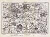
Lambert-Cholesky sheet 1758 (Timişoara)
1 : 20000 Romanian military topographic map sheet under Lambert-Cholensky projection Direcția Topografică Militară geo-spatial.org Direcția Topografică Militară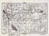
Lambert-Cholesky sheet 1757 (Pădureni)
1 : 20000 Romanian military topographic map sheet under Lambert-Cholensky projection Direcția Topografică Militară geo-spatial.org Direcția Topografică Militară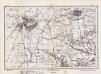
Lambert-Cholesky sheet 1756 (Jebel)
1 : 20000 Romanian military topographic map sheet under Lambert-Cholensky projection Direcția Topografică Militară geo-spatial.org Direcția Topografică Militară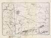
Lambert-Cholesky sheet 1755 (Vejte)
1 : 20000 Romanian military topographic map sheet under Lambert-Cholensky projection Direcția Topografică Militară geo-spatial.org Direcția Topografică Militară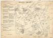
Schlacht von Temesvár am 9. August 1849
1 : 60300
Plan der Angriffsarbeiten gegen die Festung Temesvár im Jahre 1849
Walzel, A. F.
Neuster Plan der kays. Attaque vor Temeswar
Temešvár (Rumunsko)
Plan ataki ukrěplenija v Temešskom uščel'i 8 ijunja 1849 goda
1 : 7200 Temeš (Rumunsko a Srbsko) Beketov, V.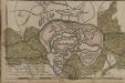
[Temeswar]
Timişoara Stadtbefestigung
Die Dorfrandzone von Gertianosch
Banat
Lambert-Cholesky sheet 1655 (Gilad)
1 : 20000 Romanian military topographic map sheet under Lambert-Cholensky projection Direcția Topografică Militară geo-spatial.org Direcția Topografică Militară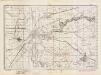
Lambert-Cholesky sheet 1555 (Ciavos)
1 : 20000 Romanian military topographic map sheet under Lambert-Cholensky projection Direcția Topografică Militară geo-spatial.org Direcția Topografică Militară
Plan der Angriffsarbeiten gegen die Festung Temesvár im Jahre 1849
1 : 14000 Temešvár (Rumunsko)
Temesvar und Sandorhaza.
from Spezialkarte der osterreichisch-ungarischen Monarchie.
Felsoittebe.
from Spezialkarte der osterreichisch-ungarischen Monarchie.
Detta
1 : 75000 Deta, Timiş Geripp: Oberlt. Charlemont. Terrain: Hptm. Stephanie
Detta.; Spezialkarte der osterreichisch-ungarischen Monarchie.
from Spezialkarte der osterreichisch-ungarischen Monarchie. Austro-Hungarian Monarchy. Militärgeographisches Institut.,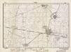
Lambert-Cholesky sheet 1559 (Cărpiniș)
1 : 20000 Romanian military topographic map sheet under Lambert-Cholensky projection Direcția Topografică Militară geo-spatial.org Direcția Topografică Militară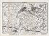
Lambert-Cholesky sheet 1659 (Becicherecul Mic)
1 : 20000 Romanian military topographic map sheet under Lambert-Cholensky projection Direcția Topografică Militară geo-spatial.org Direcția Topografică Militară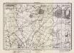
Lambert-Cholesky sheet 1759 (Giarmata)
1 : 20000 Romanian military topographic map sheet under Lambert-Cholensky projection Direcția Topografică Militară geo-spatial.org Direcția Topografică Militară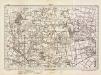
Lambert-Cholesky sheet 1858 (Bazos)
1 : 20000 Romanian military topographic map sheet under Lambert-Cholensky projection Direcția Topografică Militară geo-spatial.org Direcția Topografică Militară