Maps of Timișoara

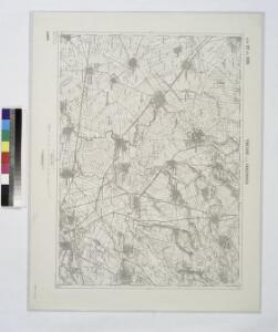
Temesvar und Sandorhaza.
from Spezialkarte der osterreichisch-ungarischen Monarchie.
Plan der Angriffsarbeiten gegen die Festung Temesvár im Jahre 1849
1 : 14000 Temešvár (Rumunsko)
Temesvár
1 : 75000 Timişoara
Schlacht von Temesvár am 9. August 1849
1 : 60300
Lambert-Cholesky sheet 1559 (Cărpiniș)
1 : 20000 Romanian military topographic map sheet under Lambert-Cholensky projection Direcția Topografică Militară geo-spatial.org Direcția Topografică Militară
Lambert-Cholesky sheet 1558 (Cenei)
1 : 20000 Romanian military topographic map sheet under Lambert-Cholensky projection Direcția Topografică Militară geo-spatial.org Direcția Topografică Militară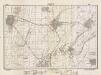
Lambert-Cholesky sheet 1661 (Mănăștur)
1 : 20000 Romanian military topographic map sheet under Lambert-Cholensky projection Direcția Topografică Militară geo-spatial.org Direcția Topografică Militară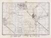
Lambert-Cholesky sheet 1660 (Hodoni)
1 : 20000 Romanian military topographic map sheet under Lambert-Cholensky projection Direcția Topografică Militară geo-spatial.org Direcția Topografică Militară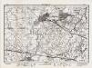
Lambert-Cholesky sheet 1659 (Becicherecul Mic)
1 : 20000 Romanian military topographic map sheet under Lambert-Cholensky projection Direcția Topografică Militară geo-spatial.org Direcția Topografică Militară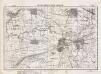
Lambert-Cholesky sheet 1658 (Sânmihaiul Român)
1 : 20000 Romanian military topographic map sheet under Lambert-Cholensky projection Serviciul Geografic al Armatei geo-spatial.org Serviciul Geografic al Armatei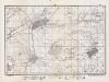
Lambert-Cholesky sheet 1761 (Vinga)
1 : 20000 Romanian military topographic map sheet under Lambert-Cholensky projection Direcția Topografică Militară geo-spatial.org Direcția Topografică Militară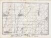
Lambert-Cholesky sheet 1760 (Jadani)
1 : 20000 Romanian military topographic map sheet under Lambert-Cholensky projection Direcția Topografică Militară geo-spatial.org Direcția Topografică Militară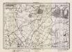
Lambert-Cholesky sheet 1759 (Giarmata)
1 : 20000 Romanian military topographic map sheet under Lambert-Cholensky projection Direcția Topografică Militară geo-spatial.org Direcția Topografică Militară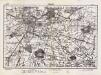
Lambert-Cholesky sheet 1758 (Timişoara)
1 : 20000 Romanian military topographic map sheet under Lambert-Cholensky projection Direcția Topografică Militară geo-spatial.org Direcția Topografică Militară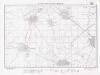
Lambert-Cholesky sheet 1560 (Şandra)
1 : 20000 Romanian military topographic map sheet under Lambert-Cholensky projection Institutul Geografic Militar geo-spatial.org Institutul Geografic Militar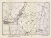
Lambert-Cholesky sheet 1561 (Pesac)
1 : 20000 Romanian military topographic map sheet under Lambert-Cholensky projection Direcția Topografică Militară geo-spatial.org Direcția Topografică Militară
Gemarkung v. Biled 1912
Biled
Gemarkung von Biled 1770
Biled
Plan der Angriffsarbeiten gegen die Festung Temesvár im Jahre 1849
Walzel, A. F.
Neuster Plan der kays. Attaque vor Temeswar
Temešvár (Rumunsko)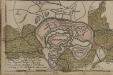
[Temeswar]
Timişoara Stadtbefestigung
Die Dorfrandzone von Gertianosch
Banat
Die Banater Schwäbische Heide zur Ansiedlungszeit nach den Originalkarten des Temeswarer Banats, aufgenommen 1769-1772 Kriegsarchiv Wien
Banat
Höhenkarte
Banat Gelände
Das heutige Landschafts- und Siedlungsbild der Banater Schwäbischen Heide
Banat
Die Nationalitätenverhältnisse der Banater Schwäbischen Heide nach der Volkszählung 1930/31
Banat ethnische Gruppe
Die hydrographischen Verhältnisse der Heide
Banat Hydrologie
Die Lage der Heide im natürlichen Landschaftsraum
Banat Landschaftsgliederung
Otelek und Szephely.
from Spezialkarte der osterreichisch-ungarischen Monarchie.