Maps of Malcesine

Storo.
from Spezialkarte der osterreichisch-ungarischen Monarchie.
Tyrolis sub Felici Regimine Mariae Theresiae Rom. Imper. Avg. Chorographice Delineata ...
1 : 104000 Mollova mapová sbírka Mansfeld, Johann Ernst Mansfeld, Johann Ernest
Verona
1 : 200000 Woerl, Joseph Edmund ; Herder, Bartholomäus Herder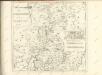

Nova et Esatta Descrizione Topografica della Riviera di Salo posta in Luce da un suo Cittadino dilettante
Mollova mapová sbírka Filosi, Giuseppe
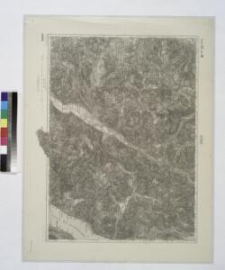
Tione und M.Adamello.
from Spezialkarte der osterreichisch-ungarischen Monarchie.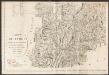
Carte du Tyrol
1 : 150000 Südwest-Blatt Anich, Peter par le Dépôt Général de la Guerre
Carte Tres Particuliere du Brassan Faisant partie des Etats de la Republique de Venise
1 : 370000 Mollova mapová sbírka Nolin, Jean-Baptiste Nolin, Jean Baptiste
Carta geologica delle provinicie Lombarde
1 : 172800 Ostblatt Curioni, G. Hoepli
Carte particulière du Bressan faisant partie des états de la république de Venise : levée par ordre exprès à l'usage des armées en Italie &c
1 : 220000 par le Sr Sanson, Geograph. du Roy A Amsterdam : chez Pierre Mortier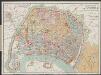
Carte Particuliere Du Bressan Faisant Partie des Etats dela Republique De Venise Leveé Par Ordre Exprès á L'Usage des Armées En Italie &c. [Karte], in: Atlas nouveau, contenant toutes les parties du monde [...], Bd. 2, S. 166.
1 Karte aus Atlas Sanson, Nicolas Jaillot, Alexis Hubert und Mortier, Pieter
TERRITORIO | di | BRESCIA | et di | CREMA
Apud Guiljelmum | et Joannem Blaeu
Verona
1 : 200000 1 Karte entworfen und bearb. von Woerl, gestochen unter seiner Leitung 1835 ; Lithographie von B. Herder Herder, Freiburg im Breisgau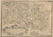
Bresciano Brixiani Agri Typus. Brixia, Cygnea supposita in specula. [Karte], in: Theatrum orbis terrarum, S. 299.
1 Karte aus Atlas Ortelius, Abraham Vrients, Jan Baptista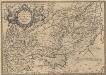
Veronae Urbis Territorium [Karte], in: Theatrum orbis terrarum, S. 290.
1 Karte aus Atlas Ortelius, Abraham Vrients, Jan Baptista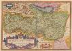
Bresciano Brixiani Agri Typus. Brixia, Cygnea supposita in specula. [Karte], in: Theatrum orbis terrarum, S. 204.
1 Karte aus Atlas Ortelius, Abraham
Territorio di Brescia et di Crema [Karte], in: Novus Atlas, das ist, Weltbeschreibung, Bd. 3, S. 112.
1 Karte aus Atlas Blaeu, Joan Blaeu, Willem Janszoon
Territorio di Brescia et di Crema [Karte], in: Le théâtre du monde, ou, Nouvel atlas contenant les chartes et descriptions de tous les païs de la terre, Bd. 3, S. 108.
1 Karte aus Atlas Blaeu, Willem Janszoon und Blaeu, Joan Blaeu, Willem Janszoon
Territorio di Brecia et di Crema [Karte], in: Theatrum orbis terrarum, sive, Atlas novus, Bd. 3, S. 94.
1 Karte aus Atlas Blaeu, Joan Blaeu, Willem Janszoon
Carte de la Suisse avec les plans des cheflieux des 22 cantons
1 : 200000 1 Karte auf 8 Bl. dessinée et publié par Henri Keller ; Lithogr. von J. Schweizer = Charte der Schweiz mit den Grundrissen der Hauptorte der 22 Cantone Keller, Zürich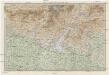
Karte der Lombardischen und Süd-Tiroler-Alpen
1 : 250000 Ravenstein, Ludwig Ludwig Ravenstein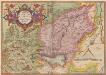
Veronae Urbis Territorium [Karte], in: Theatrum orbis terrarum, S. 195.
1 Karte aus Atlas Ortelius, Abraham
Tyrolis pars meridionalis
1 : 218000 Trident (Itálie : provincie) Spergs, Ioseph de Homannianis Hered.
Territorio di Brescia et di Crema [Karte], in: Novus atlas absolutissimus, Bd. 5, S. 29.
1 Karte aus Atlas Janssonius Offizin

Das Hertzogthum Mantova und Mirandola Sampt Angraentzenden Venedischen Laendern
1 : 500000 Mollova mapová sbírka Bodenehr, Gabriel Bodenehr, Gabriel
Territorio Di Brescia Et Di Crema [Karte], in: Gerardi Mercatoris et I. Hondii Newer Atlas, oder, Grosses Weltbuch, Bd. 2, S. 243.
1 Karte aus Atlas Mercator, Gerhard und Hondius, Jodocus Jansson, Jan
Territorio Di Trento [Karte], in: Novus Atlas, das ist, Weltbeschreibung, Bd. 3, S. 154.
1 Karte aus Atlas Blaeu, Joan Blaeu, Willem Janszoon