Maps of Târgu Secuiesc

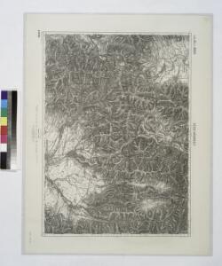
Kezdi-Vasarhely.
from Spezialkarte der osterreichisch-ungarischen Monarchie.
Kézdivásárhely
1 : 75000 Județ Covasna
Lambert-Cholesky sheet 4363 (Muntele Şandor)
1 : 20000 Romanian military topographic map sheet under Lambert-Cholensky projection Serviciul Geografic al Armatei geo-spatial.org Serviciul Geografic al Armatei
Lambert-Cholesky sheet 4362 (Esztelnek)
1 : 20000 Romanian military topographic map sheet under Lambert-Cholensky projection Serviciul Geografic al Armatei geo-spatial.org Serviciul Geografic al Armatei
Lambert-Cholesky sheet 4361 (Breţcu)
1 : 20000 Romanian military topographic map sheet under Lambert-Cholensky projection Serviciul Geografic al Armatei geo-spatial.org Serviciul Geografic al Armatei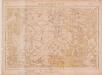
Lambert-Cholesky sheet 4263 (Doboiu)
1 : 20000 Romanian military topographic map sheet under Lambert-Cholensky projection Serviciul Geografic al Armatei geo-spatial.org Serviciul Geografic al Armatei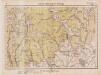
Lambert-Cholesky sheet 4262 (Polian)
1 : 20000 Romanian military topographic map sheet under Lambert-Cholensky projection Serviciul Geografic al Armatei geo-spatial.org Serviciul Geografic al Armatei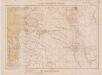
Lambert-Cholesky sheet 4261 (Kezdi-Osorhei)
1 : 20000 Romanian military topographic map sheet under Lambert-Cholensky projection Serviciul Geografic al Armatei geo-spatial.org Serviciul Geografic al Armatei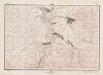
Lambert-Cholesky sheet 4163 (Tuşnad)
1 : 20000 Romanian military topographic map sheet under Lambert-Cholensky projection Direcția Topografică Militară geo-spatial.org Direcția Topografică Militară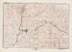
Lambert-Cholesky sheet 4162 (Bicsad)
1 : 20000 Romanian military topographic map sheet under Lambert-Cholensky projection Direcția Topografică Militară geo-spatial.org Direcția Topografică Militară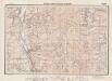
Lambert-Cholesky sheet 4161 (Malnaş)
1 : 20000 Romanian military topographic map sheet under Lambert-Cholensky projection Direcția Topografică Militară geo-spatial.org Direcția Topografică Militară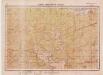
Lambert-Cholesky sheet 4364 (Poiana Uzului)
1 : 20000 Romanian military topographic map sheet under Lambert-Cholensky projection Serviciul Geografic al Armatei geo-spatial.org Serviciul Geografic al Armatei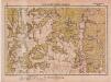
Lambert-Cholesky sheet 4264 (Părâul Uzului)
1 : 20000 Romanian military topographic map sheet under Lambert-Cholensky projection Serviciul Geografic al Armatei geo-spatial.org Serviciul Geografic al Armatei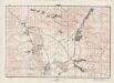
Lambert-Cholesky sheet 4164 (Sânsimion)
1 : 20000 Romanian military topographic map sheet under Lambert-Cholensky projection Direcția Topografică Militară geo-spatial.org Direcția Topografică Militară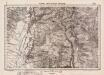
Lambert-Cholesky sheet 4160 (Bodok)
1 : 20000 Romanian military topographic map sheet under Lambert-Cholensky projection Serviciul Geografic al Armatei geo-spatial.org Serviciul Geografic al Armatei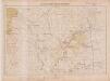
Lambert-Cholesky sheet 4260 (Cernatul de Jos)
1 : 20000 Romanian military topographic map sheet under Lambert-Cholensky projection Serviciul Geografic al Armatei geo-spatial.org Serviciul Geografic al Armatei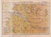
Lambert-Cholesky sheet 4360 (Ghelinţa)
1 : 20000 Romanian military topographic map sheet under Lambert-Cholensky projection Serviciul Geografic al Armatei geo-spatial.org Serviciul Geografic al Armatei
Czik-Menasag.
from Spezialkarte der osterreichisch-ungarischen Monarchie.
Ojtoz Pasz.
from Spezialkarte der osterreichisch-ungarischen Monarchie.
Kovaszna.; Spezialkarte der osterreichisch-ungarischen Monarchie.
from Spezialkarte der osterreichisch-ungarischen Monarchie. Austro-Hungarian Monarchy. Militärgeographisches Institut.,
Kovászna
1 : 75000 Covasna
Lambert-Cholesky sheet 4063 (Muntele Cucului)
1 : 20000 Romanian military topographic map sheet under Lambert-Cholensky projection Direcția Topografică Militară geo-spatial.org Direcția Topografică Militară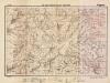
Lambert-Cholesky sheet 4062 (Băţanii Mari)
1 : 20000 Romanian military topographic map sheet under Lambert-Cholensky projection Direcția Topografică Militară geo-spatial.org Direcția Topografică Militară
Lambert-Cholesky sheet 4061 (Aita Seacă)
1 : 20000 Romanian military topographic map sheet under Lambert-Cholensky projection Direcția Topografică Militară geo-spatial.org Direcția Topografică Militară
Generalkarte von Zentraleuropa

Ost-Karpathen
1 : 600000 Karpaten (Südost)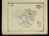
Harta Cailor de Comunicatie din Judetul Bacau
Rumänien Judeţ Bacău Verkehrsweg
Barot.
from Spezialkarte der osterreichisch-ungarischen Monarchie.
Csik-Ménaság
1 : 75000 Csíkmenaság, Judeţ Harghita