Maps of Fonyódi járás

Somogyvar.
from Spezialkarte der osterreichisch-ungarischen Monarchie.
Somogyvár
1 : 75000 Somogyvár, Komitat Somogy
Kaposvar und Bohonye.
from Spezialkarte der osterreichisch-ungarischen Monarchie.
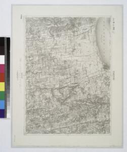
Nagyvazsony und Badacsonytomaj.
from Spezialkarte der osterreichisch-ungarischen Monarchie.
Kaposvár
1 : 75000 Kaposvár
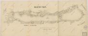
Badacsonytomaj
1 : 25000 Maďarsko MM. Kir. Állami Térképészet
Szalader com[it.] Schackmin Cvrassie Regiments
1 : 467000 Balaton-oblast (Maďarsko) Cir, V.
Somogy vármegye térképe
1 : 400000 Kaposvár (Maďarsko) Kogutowicz, Manó Magyar Földrajzi Intézet
Comitat Somogy
1 : 300000
C. Sümeghiensis
Ungarn Komitat Somogy
C. Szaladiensis. Tab. III
Ungarn Komitat Zala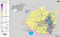
Siedlungsgebiet der Deutschen nach dem Nachbarschaftsindex für Süd-Transdanubien 1880
Ungarn (Süd) Deutsche, Siedlung Bottlik, Zsolt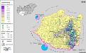
Siedlungsgebiet der Deutschen nach dem Nachbarschaftsindex für Süd-Transdanubien 1941
Ungarn (Süd) Deutsche, Siedlung Bottlik, Zsolt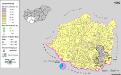
Siedlungsgebiet der Deutschen nach dem Nachbarschaftsindex für Süd-Transdanubien 1980
Ungarn (Süd) Deutsche, Siedlung Bottlik, Zsolt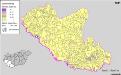
Kroaten in Südwest-Ungarn 1941
Transdanubien (Süd) Kroaten, Siedlung Bottlik, Zsolt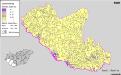
Kroaten in Südwest-Ungarn 1880
Transdanubien (Süd) Kroaten, Siedlung Bottlik, Zsolt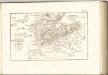
Balaton Tava
Balaton turistická mapa

Stuhlweissenburg 162, uit: Special-Karte von Mittel-Europa / nach amtlichen Quellen bearbeitet von W. Liebenow
1 : 300000 titelvariant: W. Liebenow's Mittel-Europa; Annotatie: Titel boven de bladen: W. Liebenow's Mittel-Europa Johannes Wilhelm Liebenow 1822-1897 Frankfurt a. M. : Ludwig Ravenstein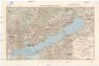
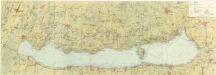
Balaton und Umgebung
1 : 200000 Balaton (Maďarsko : jezero : oblast) M. Kir. Állami Térképészet
Tamasi und Igal.
from Spezialkarte der osterreichisch-ungarischen Monarchie.
Kis-Komarom und Zala-Szt.-Mihaly.
from Spezialkarte der osterreichisch-ungarischen Monarchie.
Nagy-Vázsony
1 : 75000 Nagyvázsony, Komitat Veszprém
Tamási
1 : 75000 Tamási, Komitat Tolna
Balatonfured und Varos-Hidveg.
from Spezialkarte der osterreichisch-ungarischen Monarchie.
Dombovar.
from Spezialkarte der osterreichisch-ungarischen Monarchie.
Sumeg und Zala-Egerszeg.
from Spezialkarte der osterreichisch-ungarischen Monarchie.