Maps of Bezirk Hartberg-Fürstenfeld

Furstenfeld.
from Spezialkarte der osterreichisch-ungarischen Monarchie.
Bataille de St. Gotthard
Nouvel atlas physique politique et historique de l'Empire ottoman et des états limitrophes en Europe, en Asie et en Afrique, en quarante feuilles Hellert, J.J. Bellizard, Dufour et Cie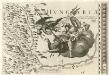
Stÿriae Ducatus Fertilisimi Nova Geographica Descriptio
1 : 200000 Mollova mapová sbírka Vischer, Georg Matthaeus Trost, Andreas

Hartberg und Pinkafeld (Ankafo).
from Spezialkarte der osterreichisch-ungarischen Monarchie.
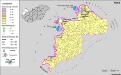
Gleichenberg.
from Spezialkarte der osterreichisch-ungarischen Monarchie.
Steinamanager und Kormend.
from Spezialkarte der osterreichisch-ungarischen Monarchie.
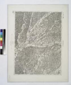
Graz.
from Spezialkarte der osterreichisch-ungarischen Monarchie.
Gleichenberg
1 : 75000 Bad Gleichenberg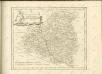

Lutzelfrau und Pudelmutter in der Oststeiermark und im Burgenland
Steiermark, Burgenland, Volkskunde Umschaden, Kurt ; Neunteufl, Walter
Wirtschaftskarte
Mittelsteiermark Wirtschaft
Landschaftstypen und zugehörige Wirtschaftsformen
Mittelsteiermark Landschaftsgliederung, Wirtschaft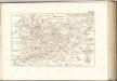

Der Noerdliche Theil von Untersteyermark oder der Graetzer Kreis
1 : 260000 Rakousko Kindermann, Joseph Karl Junker, Christoph bey Franz Xaver Miller
Generalkarte vom Burgenland
1 : 200000 Burgenland (Rakousko) R. Lechner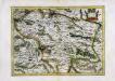
Stiria
1 Karte : Kupferdruck ; 29 x 40 cm Mercator; Hondius Henricus Hondius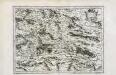
Stiria
1 Karte : Kupferdruck ; 29 x 40 cm Mercator s.n.
A németek településterülete a szomszédsági mutató alapján Nyugat-Magyarországon 1880-ban
Ungarn, Transdanubien, Deutsche, Siedlung Bottlik, Zsolt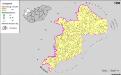
A németek településterülete a szomszédsági mutató alapján Nyugat-Magyarországon 1980-ban
Ungarn, Transdanubien, Deutsche, Siedlung Bottlik, Zsolt
Handkarte des Herzogthumes Steiermark
1 : 750000 Štýrsko (Rakousko) Schober, Karl k. u. k. milit.-geograph. Institut
A németek településterülete a szomszédsági mutató alapján Nyugat-Magyarországon 1941-ban
Ungarn, Transdanubien, Deutsche, Siedlung Bottlik, Zsolt
Verschiebung der Bevölkerung 1910-1920/23
Mittelsteiermark Bevölkerungsentwicklung
Der nœrdliche Theil von Untersteyermark oder der Grætzer Kreis
1 Karte : Kupferdruck ; 46 x 50 cm Kindermann; Miller; Junker verlegt bey Franz Xaver Miller Buchhændlern
C. Castriferrei
Ungarn Komitat Vas
A horvátok aránya és száma Nyugat-Magyarországon 1880-ban
Transdanubien Kroaten, Siedlung Bottlik, Zsolt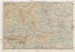
Karte der Steierischen Alpen und der Karawanken
1 : 250000 Karavanky (Rakousko a Slovinsko : pohoří) Ravenstein, Ludwig Ludwig Ravenstein
Graz 160, uit: Special-Karte von Mittel-Europa / nach amtlichen Quellen bearbeitet von W. Liebenow
1 : 300000 titelvariant: W. Liebenow's Mittel-Europa; Annotatie: Titel boven de bladen: W. Liebenow's Mittel-Europa Johannes Wilhelm Liebenow 1822-1897 Frankfurt a. M. : Ludwig Ravenstein