Maps of Obdach

Judenburg.
from Spezialkarte der osterreichisch-ungarischen Monarchie.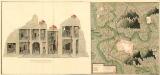
Plan der Bergwergs Schatenstein
Mollova mapová sbírka Geyer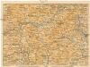
[Graz und Umgebung]
1 : 500000 Štýrský Hradec (Rakousko : oblast) Wagner & Debes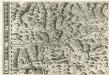
Stÿriae Ducatus Fertilisimi Nova Geographica Descriptio
1 : 200000 Mollova mapová sbírka Vischer, Georg Matthaeus Trost, Andreas
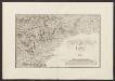
Geologische Karte der Umgebungen von Leoben und Judenburg
1 : 144000 Morlot, Adolph von David
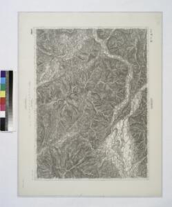
St. Johann am Tauern.
from Spezialkarte der osterreichisch-ungarischen Monarchie.
Hittenberg und Eberstein.
from Spezialkarte der osterreichisch-ungarischen Monarchie.
Murau.
from Spezialkarte der osterreichisch-ungarischen Monarchie.
Koflach und Voitsberg.
from Spezialkarte der osterreichisch-ungarischen Monarchie.
Neueste special Karte des Judenburger Kreises im Herzogthume Steyermark
1 : 210000 Štýrsko (Rakousko) Kaiser, Jos. Fr. Jos. Fr. Kaiser
Neueste special Karte des Judenburger Kreises im Herzogthume Steyermark
1 : 216000 Štýrsko (Rakousko) Kaiser, Joseph Franz Jos. Fr. Kaiser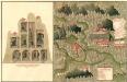
Plan des C. und 5. Bergwerg St. Ulrich an Unter Frauen Bach in Hutthal, in Unter Carnt;
Mollova mapová sbírka Geyer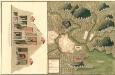
Plan des in Ober Carnten Gold Bergwergs Velach
Mollova mapová sbírka Geyer
Orographisch-hidrographische Carte des Herzogthums Steyermark
Štýrsko (Rakousko) Schmutz, Carl Hartwig, Eduard Joseph Franz Kaiser
Orographisch-hidrographische Carte des Herzogthums Steyermark
Štýrsko (Rakousko) Schmutz, Carl Hartwig, Eduard Joseph Franz Kaiser
Der westliche Theil von Obersteyermark oder der Judenburger Kreis
1 : 250000 Horní Rakousko (Rakousko) Kindermann, Joseph Karl Junker, Christoph Franz Xaver Miller
Generalkarte von Zentraleuropa
Militair Karte von Süd-Deutschland in 20 Sectionen
1 : 400000 20. Section Coulon, Alois von A. von Coulon
Carinthiae Dvcatvs, Et Goritiae Palatinatvs
1 : 460000 Mollova mapová sbírka Lazius, Wolfgang
General-Karte des Herzogthums Steyermark
1 : 288000 Oltenie (Rumunsko) Schönfelder, E. von C. J. Wawra Kunst und Landkartenhandlung
General-Karte von Kärnten
1 : 300000 Klagenfurt (Rakousko) R. Lechner
General-Karte von Kärnten
1 : 300000 Klagenfurt (Rakousko) R. Lechner
Carinthia ducatus distincta in superiorem et inferior
1 : 350000 Korutansko (Rakousko) Lotter, Tobias Conrad T. C. Lotter
Carinthia ducatus distincta in superiorem et inferior
1 : 350000 Korutansko (Rakousko) Lotter, Tobias Conrad T. C. Lotter
Carinthia ducatus distincta in superiorem et inferior
1 : 350000 Korutansko (Rakousko) Lotter, Tobias Conrad per Tobiam Conradum Lotter
Carinthia ducatus distincta in superiorem et inferior
1 : 350000 Korutansko (Rakousko) Lotter, Tobias Conrad per Tobiam Conradum Lotter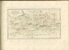

Carinthia Ducatus distincta in Superiorem et Inferior
1 : 360000 Mollova mapová sbírka Seutter, Matthäus
Nova et accurata Carinthiae Ducatus Tabula geographica
1 : 355000 Mollova mapová sbírka Homann, Johann Baptist