Maps of Nagykátai járás

Nagykata und Monor.; Spezialkarte der osterreichisch-ungarischen Monarchie.
from Spezialkarte der osterreichisch-ungarischen Monarchie. Austro-Hungarian Monarchy. Militärgeographisches Institut.,
Nagykáta
1 : 75000 Nagykáta, Komitat Pest
Mappa Comitatus Pilisiensis Methodo Astronomico-Geometrica concinnata.
1 : 162500 Mollova mapová sbírka Mikoviny, Sámuel Nicolaï, Georg David Christoph
Mappa Comitatus Pesthiensis Methodo Astronomico-Geometrica, concinnata.
1 : 166600 Mollova mapová sbírka Mikoviny, Sámuel Nicolaï, Georg David Christoph
Pesth-Piliser Comitat
1 : 280000 Budapešť-oblast (Maďarsko)
Jász-Berény 149, uit: Special-Karte von Mittel-Europa / nach amtlichen Quellen bearbeitet von W. Liebenow
1 : 300000 titelvariant: W. Liebenow's Mittel-Europa; Annotatie: Titel boven de bladen: W. Liebenow's Mittel-Europa Johannes Wilhelm Liebenow 1822-1897 Frankfurt a. M. : Ludwig Ravenstein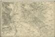
Bez titulu: Umgebungen von Pest

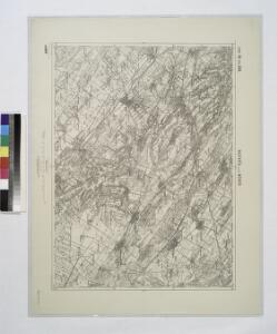
Czegled.
from Spezialkarte der osterreichisch-ungarischen Monarchie.
Budapest und Teteny.
from Spezialkarte der osterreichisch-ungarischen Monarchie.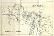
Stolice Pešť-Pilišská. Stolice Komárno a Ostřihom
Komitat Komárom-Esztergom, Komitat Pest-Pilis-Solt-Kiskun, ethnische Gruppe
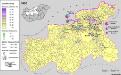
Serben im Komitat Pest 1980
Komitat Pest Serben, Siedlung Bottlik, Zsolt
C. Pestensis
Ungarn Komitat Pest
Serben im Komitat Pest 1880
Komitat Pest Serben, Siedlung Bottlik, Zsolt
Serben im Komitat Pest 1941
Komitat Pest Serben, Siedlung Bottlik, Zsolt
A szerbek aránya és száma Pest megyében 1880-ban
Komitat Pest Serben, Siedlung Bottlik, Zsolt
A szerbek aránya és száma Pest megyében 1941-ben
Komitat Pest Serben, Siedlung Bottlik, Zsolt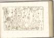

A szerbek aránya és száma Pest megyében 1980-ban
Komitat Pest Serben, Siedlung Bottlik, Zsolt
Generalkarte von Zentraleuropa

Pest-Pilis-Solt-Kiskun vármegye
1 : 500000 Budapešť (Maďarsko : oblast) Kogutowicz, Manó Magyar Földrajzi Intézet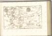
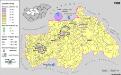
Siedlungsgebiet der Deutschen nach dem Nachbarschaftsindex für Mittel-Transdanubien 1980
Ungarn, Zentralungarn, Deutsche, Siedlung Bottlik, Zsolt
Pesth-Solter, Csongráder, Szolnoker Comitat und das Ober Capitanat von Jazygien und Cumanien
1 : 280000 Budapešť-oblast (Maďarsko)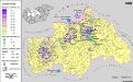
Siedlungsgebiet der Deutschen nach dem Nachbarschaftsindex für Mittel-Transdanubien 1880
Ungarn, Zentralungarn, Deutsche, Siedlung Bottlik, Zsolt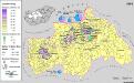
Siedlungsgebiet der Deutschen nach dem Nachbarschaftsindex für Mittel-Transdanubien 1941
Ungarn, Zentralungarn, Deutsche, Siedlung Bottlik, Zsolt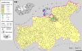
Siedlungsgebiet der Slowaken nach dem Nachbarschaftsindex für Mittel-Transdanubien 1941
Ungarn, Zentralungarn, Slowaken, Siedlung Bottlik, Zsolt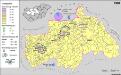
A németek településterülete a szomszédsági mutató alapján Közép-Dunántúlon 1980-ban
Ungarn, Zentralungarn, Deutsche, Siedlung Bottlik, Zsolt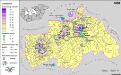
A németek településterülete a szomszédsági mutató alapján Közép-Dunántúlon 1880-ban
Ungarn, Zentralungarn, Deutsche, Siedlung Bottlik, Zsolt
Siedlungsgebiet der Slowaken nach dem Nachbarschaftsindex für Mittel-Transdanubien 1980
Ungarn, Zentralungarn, Slowaken, Siedlung Bottlik, Zsolt