Maps of Appenzell Ausserrhoden

Hohenems.
from Spezialkarte der osterreichisch-ungarischen Monarchie.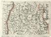
Geographica Provinciarum Sveviae Descriptio =
Mollova mapová sbírka Hurter, Johann Christoph Bodenehr, Gabriel
Pagus Helvetiae Abbatiscellanus
1 : 80000 Mollova mapová sbírka Walser, Gabriel Lotter, Tobias Conrad Seutter, Matthäus
Canton Appenzell sive Pagus Helvetiae Abbatiscellanum cum Confinibus recenter delineatus
1 : 90000 Mollova mapová sbírka Walser, Gabriel Homann, Johann Baptista - dědici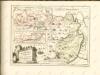

Reise- u. Touristen-Karte des Kantons Appenzell und Umgebung
1 : 100000 E. Wagner
Karte des Kantons Appenzell
1 : 130000 1 Karte Topogr. Anstalt v. Wurster, Randegger & Cie., Winterthur
Atlas novus Reipublicae Helveticae
1 Atlas ([40] Bl., 97 S.) bey Orell, Gessner und Compagnie, Zürich
Karte des Kantons Appenzell & Umgebung
1 : 100000 1 Karte bearbeitet u. gestochen von E. Wagner [Verlag nicht ermittelbar], [Erscheinungsort nicht ermittelbar]
Delineatio aller Quartieren der Statt und Landschaft Zürich
1 : 200000 1 Karte von Joh. Heinr. Freytag
Hohenems
1 : 75000 k.k. Militärgeograph. Inst.
Pagus Helvetiae abbatiscellanus cum com[m]unitatibus interioribus et exterioribus, ac adjacente Valle Rhenana, accurate delineatus
1 : 115000 Švýcarsko Walser, Gabriel Seutter, Matthäus sumptibus Matth. Seutteri
Hohenems
1 : 75000 Kartograph., früher Militärgeograph. Inst.
Pagus helvetiæ Abbatiscellanus
1 Karte : Kupferdruck ; 49 x 56 cm Walser; Seutter; Lotter; Eichler; Probst anjezo in Verlag bey Ioh. Mich. Probst Chalc
Pagus helvetiæ Abbatiscellanus
1 Karte : Kupferdruck ; 49 x 56 cm Walser; Seutter; Lotter; Eichler; Probst anjezo in Verlag bey Ioh. Mich. Probst Chalc
Pagus helvetiæ Abbatiscellanus
1 Karte : Kupferdruck ; 49 x 57 cm Walser; Seutter; Lotter; Eichler Matthäus Seutter
Charte vom Kanton Appenzell
1 : 125000 Zuber, Johannes ; Gsell, J.L. [s.n.]
[Karte Der Gefürsteten Grafschaft Tyrol Nebst Vorarlberg Und dem angrenzenden Souverainen Fürstenthum Liechtenstein]
Generalquartiermeisterstab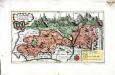
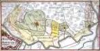
Das Land Appenzell der Innern- u. Aussern-Rooden
1 Karte : Kupferdruck ; 20 x 36 cm Walser s.n.

Hans Konrad Gyger's Züricher-Cantons-Carte 1667
1 : 32000 1 Karte in 56 Teilen Hans Konrad Gyger
[Bregenz]
1 : 86400 Amman, Ignaz Ambros Cotta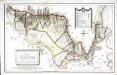
Specialcharte des Rheinthals
1 Karte : Kupferdruck ; 40 x 65 cm Feer; Lips; Custer s.n.
Wandkarte des Cantons Appenzell
1 : 35700 1 Karte auf 4 Blättern J.M. Müller, B. Tanner 1859 Wurster, Winterthur
Hans Konrad Gyger's Züricher-Cantons-Carte 1667
1 : 32000 1 Karte in 56 Teilen Hans Konrad Gyger
Wandkarte des Cantons Appenzell
1 : 35700 1 Karte auf 4 Blättern J.M. Müller, B. Tanner 1859 Wurster, Winterthur
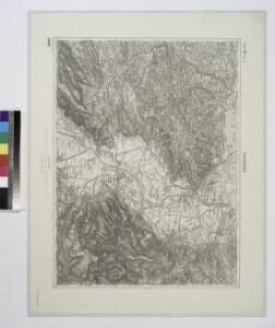
Topographische Karte des Cantons St. Gallen mit Einschluss des Cantons Appenzell
1 : 25000 16 Karten aufgenommen von J. Eschmann ... [et al.] ; gestochen von P. Steiner ; Gebirg von J. Randegger ; Gebirgszeichnung u. Leitung des Stiches durch J.M. Ziegler Topographische Anstalt v. Joh. Wurster & Comp., Winterthur