Maps of Nyírbátor

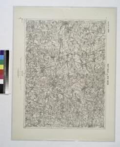
Nagy-Kallo und Nyir-Bator.; Spezialkarte der osterreichisch-ungarischen Monarchie.
from Spezialkarte der osterreichisch-ungarischen Monarchie. Austro-Hungarian Monarchy. Militärgeographisches Institut.,
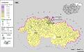
Nagy-Kálló und Nyir-Bátor
1 : 75000 Nagykálló, Nyírbátor Geripp: J. Schwarz. Terrain: Oberlt. Julius Bressa
Lambert-Cholesky sheet 2381 (Fabian)
1 : 20000 Romanian military topographic map sheet under Lambert-Cholensky projection Serviciul Geografic al Armatei geo-spatial.org Serviciul Geografic al Armatei
Generální mapa ČSR
Szabolcser Comitat
1 : 280000 Szabolcs-Szatmár-Bereg (Maďarsko)
Szabolcser Comitat
1 : 280000 Szabolcs-Szatmár-Bereg (Maďarsko)
Szathmárer Comitat
1 : 280000 Satu-Mare-oblast (Rumunsko)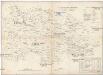
Szathmárer Comitat
1 : 300000 Satu-Mare (Rumunsko : oblast)
Comitat Nord-Bihar
1 : 288000 Debrecín (Maďarsko)
Szatmár vármegye térképe
1 : 425000 Maďarsko Kogutowicz, Manó Magyar Földrajzi Intézet
Kis-Varda und Vasaros-Nameny.
from Spezialkarte der osterreichisch-ungarischen Monarchie.
Jank.
from Spezialkarte der osterreichisch-ungarischen Monarchie.
Nyir-Beltek und Hajdu-Yamos-Percs.
from Spezialkarte der osterreichisch-ungarischen Monarchie.
Nyiregyhaza und Hajdu-Nans.
from Spezialkarte der osterreichisch-ungarischen Monarchie.
Lambert-Cholesky sheet 2280 (Nirbetlek)
1 : 20000 Romanian military topographic map sheet under Lambert-Cholensky projection Institutul Geografic al Armatei geo-spatial.org Institutul Geografic al Armatei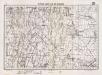
Lambert-Cholesky sheet 2380 (Foen)
1 : 20000 Romanian military topographic map sheet under Lambert-Cholensky projection Serviciul Geografic al Armatei geo-spatial.org Serviciul Geografic al Armatei
C. Szabolcs
Ungarn Slowakei Komitat Szabolcs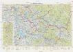
Neubertova generální automapa Republiky československé
1 : 200000 Chust (Ukrajina) Soukup, Jan V. Neubert a synové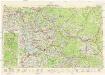
Neubertova generální automapa Republiky československé
1 : 200000 Chust (Ukrajina) Soukup, Jan V. Neubert a synové
Siedlungsgebiet der Slowaken nach dem Nachbarschaftsindex für Nordost-Ungarn 1941
Ungarn (Nordost) Slowaken, Siedlung Bottlik, Zsolt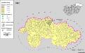
Siedlungsgebiet der Slowaken nach dem Nachbarschaftsindex für Nordost-Ungarn 1980
Ungarn (Nordost) Slowaken, Siedlung Bottlik, Zsolt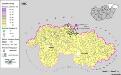
Siedlungsgebiet der Slowaken nach dem Nachbarschaftsindex für Nordost-Ungarn 1880
Ungarn (Nordost) Slowaken, Siedlung Bottlik, Zsolt
Sbírka map a diagramů použitých na mírových konferencích v Paříži v letech 1919 - 1920
A szlovákok településterülete a szomszédsági mutató alapján Északkelet-Magyarországon 1880-ban
Ungarn (Nordost) Slowaken, Siedlung Bottlik, Zsolt
A szlovákok településterülete a szomszédsági mutató alapján Északkelet-Magyarországon 1980-ban
Ungarn (Nordost) Slowaken, Siedlung Bottlik, Zsolt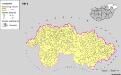
A szlovákok településterülete a szomszédsági mutató alapján Északkelet-Magyarországon 1941-ban
Ungarn (Nordost) Slowaken, Siedlung Bottlik, Zsolt
Partis Hungariae Inter Tibiscum et Nigrum Chrysum Nova et Accurata Descriptio
1 : 530000 Mollova mapová sbírka Valk, Gerhard Schenk, Peter I
Ober Ungern
Slovensko východní Kipferling, Karl Joseph Müller, Karl im Verlage des Kunst und Industrie Comptoir's
Ober Ungern
Slovensko východní Kipferling, Karl Joseph Müller, Karl im Verlage des Kunst und Industrie Comptoir's