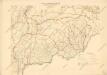
Maps of Salgótarjáni járás

Arlo und K.Terenne (Ungarn).
from Spezialkarte der osterreichisch-ungarischen Monarchie.
III. vojenské mapování 4764
1 : 75000
Hajnáčka
1 : 75000 Maďarsko Vojenský zeměpisný ústav
Hajnáčka
1 : 75000 Maďarsko Vojenský zeměpisný ústav
Arló und K. Terenne
1 : 75000 Arló, Komitat Heves Schrift und Gerippe v. G. Linser. Terrainschraffirung v. Contractz. Le Gay Ed v. Lierfels
III. vojenské mapování 4764/1
1 : 25000
[Gradkartenblatt]
1 : 25000 Slovensko
[Gradkartenblatt]
1 : 25000 Slovensko
III. vojenské mapování 4764/2
1 : 25000
Čakanovce, berní okres Lučenec, země Slovenská
1 : 2880 Lučenec (Slovensko : oblast) Reprodukční ústav Ministerstva financí
Gyongyos und Bakta (Ungarn).
from Spezialkarte der osterreichisch-ungarischen Monarchie.
Salgo-Tarjan und Nagyszecseny.
from Spezialkarte der osterreichisch-ungarischen Monarchie.
Miskolcz.
from Spezialkarte der osterreichisch-ungarischen Monarchie.
Rimavská Sobota, Číž – Domica
Mátra hegység
1 : 50000 Mátra (Maďarsko : pohoří) M. Kir. Állami Térképészet
[Mapový list]
1 : 25000 Slovensko Vojenský zeměpisný ústav
[Mapový list]
1 : 25000 Slovensko Vojenský zeměpisný ústav
III. vojenské mapování 4763
1 : 75000
Gyöngyös und Bakta
1 : 75000 Gyöngyös Geripp: Fwkr. Suchanek. Terrain: Hauptm. Peraković u. Oberlt. Kuźmin
Rima-Szombat
1 : 75000 Rimavská Sobota Schrift u. Gerippe v. Führ. Schwarz. Terrainschraffirung v. Fwkr. Nowak u. R. Bloschitz
III. vojenské mapování 4664/4
1 : 25000
[Gradkartenblatt]
1 : 25000 Slovensko
III. vojenské mapování 4763/2
1 : 25000
III. vojenské mapování 4665/3
1 : 25000
[Mapový list]
1 : 25000 Slovensko Vojenský zeměpisný ústav
Rima-Szombat 135, uit: Special-Karte von Mittel-Europa / nach amtlichen Quellen bearbeitet von W. Liebenow
1 : 300000 titelvariant: W. Liebenow's Mittel-Europa; Annotatie: Titel boven de bladen: W. Liebenow's Mittel-Europa Johannes Wilhelm Liebenow 1822-1897 Frankfurt a. M. : Ludwig Ravenstein
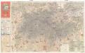
Gömör vármegye és a' vele törvényesen egyesült Kis-Honti kerület
1 : 240000 Gemer (Slovensko : oblast) Ráisz, Christ. Benedicti, Hieronymus Görög
Zipser Comitat
1 : 280000 Spiš (Slovensko)
Kraj banskobystrický