Maps of Salgótarjáni járás

Salgo-Tarjan und Nagyszecseny.
from Spezialkarte der osterreichisch-ungarischen Monarchie.
Sklabiná
1 : 75000 Maďarsko Vojenský zeměpisný ústav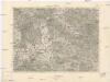
Sklabiná
1 : 75000 Maďarsko Vojenský zeměpisný ústav
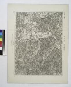
Sklabiná a Salgótarján
1 : 75000 Maďarsko Vojenský zeměpisný ústav
III. vojenské mapování 4763
1 : 75000
[Mapový list]
1 : 25000 Slovensko Vojenský zeměpisný ústav
III. vojenské mapování 4763/1
1 : 25000
[Gradkartenblatt]
1 : 25000 Slovensko
III. vojenské mapování 4763/2
1 : 25000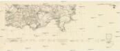
[Mapový list]
1 : 25000 Slovensko Vojenský zeměpisný ústav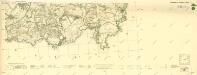
III. vojenské mapování 4763/3
1 : 25000
Čakanovce, berní okres Lučenec, země Slovenská
1 : 2880 Lučenec (Slovensko : oblast) Reprodukční ústav Ministerstva financí
C. Neogradiensis
Ungarn Komitat Nógrád
Nográd vármegye térképe
1 : 390000 Slovensko Kogutowicz, Manó Magyar Földrajzi Intézet
Neograder-Comitat
1 : 288000 Novohrad (Slovensko a Maďarsko)
Neograder-Comitat
1 : 288000 Novohrad (Slovensko a Maďarsko)
Neograder-Comitat
1 : 288000 Novohrad (Slovensko a Maďarsko)
Mappa comitatvs Neogradiensis
1 : 160000 Novohrad (Slovensko a Maďarsko) Mikoviny, Sámuel Nicolai, Georg David Christoph
Paszto und Apcz (Ungarn).
from Spezialkarte der osterreichisch-ungarischen Monarchie.
Losoncz (Ungarn).
from Spezialkarte der osterreichisch-ungarischen Monarchie.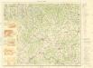
Lučenec a okolie

Arlo und K.Terenne (Ungarn).
from Spezialkarte der osterreichisch-ungarischen Monarchie.
Balassa-Gyarmat und Ipoly-Sag.
from Spezialkarte der osterreichisch-ungarischen Monarchie.
Pásztó und Apcz
1 : 75000 Pásztó, Umland Geripp: Fwkr. Lendl. Terrain: Fwkr. Kotrtsch
[Gradkartenblatt]
1 : 25000 Slovensko
III. vojenské mapování 4664/3
1 : 25000
III. vojenské mapování 4663/4
1 : 25000
[Mapový list]
1 : 25000 Lučenec-oblast (Slovensko) Vojenský zeměpisný ústav
III. vojenské mapování 4663/3
1 : 25000