Maps of Borschiv Raion

Mielnica.
from Spezialkarte der osterreichisch-ungarischen Monarchie.
Mielnica
1 : 75000 Ukrajina Halla, R. K. u. k. Militärgeographisches Institut
Czernowitz.
from Spezialkarte der osterreichisch-ungarischen Monarchie.
Borszczow.
from Spezialkarte der osterreichisch-ungarischen Monarchie.
Kamieniec Podolski.
from Spezialkarte der osterreichisch-ungarischen Monarchie.
Zaleszczyki (Galizien).
from Spezialkarte der osterreichisch-ungarischen Monarchie.
Ost-Galizien
Halič (Polsko a Ukrajina) Liesganig, Joseph im Verlage des Kunst und Industrie Comptoirs
Generalkarte von Zentraleuropa

Generalkarte von Zentraleuropa


Czernowitz
1 : 75000 Ukrajina Leixner, F. K. u. k. Militärgeographisches Institut
Kamieniec Podolski
1 : 75000 Novakovic K. u. k. Militärgeographisches Institut
Borszczów
1 : 75000 Ukrajina Kraupa, G. K. u. k. Militärgeographisches Institut
Jagielnica und Czernelica.
from Spezialkarte der osterreichisch-ungarischen Monarchie.
Zaleszczyki
1 : 75000 Ukrajina Marcovich, A. Conte K. u. k. Militärgeographisches Institut
Jagielnica und Czernelica
1 : 75000 Ukrajina K. u. k. Militärgeographisches Institut
Sniatyn.; Spezialkarte der osterreichisch-ungarischen Monarchie.
from Spezialkarte der osterreichisch-ungarischen Monarchie. Austro-Hungarian Monarchy. Militärgeographisches Institut.,
Neue Generalkarte des Österr.-ungar.-russischen Kriegsschauplatzes

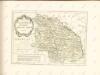
Ukrainae pars, quae Podolia palatinatus vulgo dicitur / per Guil. le Vasseur de Beauplan s. r. m.tis
1 : 420000 1 Karte : Kupferdruck ; 43 x 52 cm Beauplan, Guillaume le Vasseur de [Verlag nicht ermittelbar]
Russia
Mollova mapová sbírka Hoffmann, Johannes Hoffmann, Johann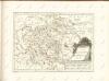
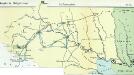
Nr. 6b. Kämpfe in Ostgalizien. Im Dnjestrgebiet
Galizien Weltkrieg <1914-1918>, Ostfront
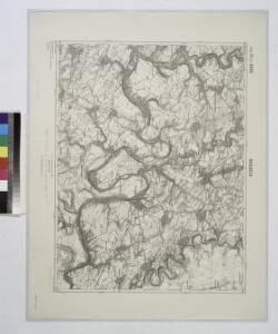
Tarnopol, Brody, Stryj, Czernowitz
1 : 750000 Brody (Ukrajina) Erben, F. K. u. k. Militärgeographisches Institut
Tarnopol, Brody, Stryj, Czernowitz
1 : 750000 Brody (Ukrajina) Erben, F. K. u. k. Militärgeographisches Institut
Tarnopol, Brody, Stryj, Czernowitz
1 : 750000 K. u. k. militär-geographisches Institut
Tarnopol, Brody, Stryj, Czernowitz
1 : 750000 Brody (Ukrajina) K. k. militär-geographisches Institut