Maps of powiat tatrzański

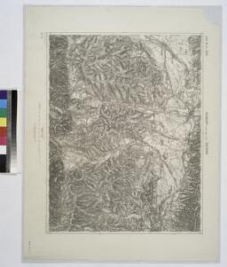
Neumarkt (Nowytarg) und Zakopane.
from Spezialkarte der osterreichisch-ungarischen Monarchie.
Zone 8, Kol. XXII, Neumarkt (Nowytarg) und Zakopane, uit: Geologische Karte der im Reichsrathe vertretenen Königreiche und Länder der Österreich-Ungarischen Monarchie : auf Grundlage der Specialkarte i.M. 1:75.000 des k.u.k. Militär-geographischen Institutes / neu bearb. und als Kartenwerk von 341 Blattnummern in zwanglosen Lfg. hrsg. durch die k.k. Geologische Reichsanstalt in Wien
1 : 75000 titelvariant: Geologische Spezialkarte der im Reichsrate vertretenen Königreiche und Länder der Österreichisch-Ungarischen Monarchie; Geologische Specialkarte der im Reichsrathe vertretenen Königreiche und Länder der Österreichisch-Ungarischen Monarchie; Annotatie: Titel bovenaan kaartblad: Geologische Spezialkarte der im Reichsrate vertretenen Königreiche und Länder der Österreichisch-Ungarischen Monarchie en Geologische Specialkarte der im Reichsrathe vertretenen Königreiche und Länder der Österreichisch-Ungarischen Monarchie; Annotatie geografische gegevens: Coördinaten gebaseerd op nulmeridiaan van Ferro (Hierro) Kaiserlich-Königliche Geologische Reichsanstalt, Wenen Wien : K.K. Geologische Reichsanstalt
Nowy Targ
1 : 75000 Nowy Targ, Umland
III. vojenské mapování 4264
1 : 75000
Ždiar
1 : 75000 Slovensko Vojenský zeměpisný ústav
Ždiar a Zakopane
1 : 75000 Polsko Vojenský zeměpisný ústav
Ždiar a Zakopane
1 : 75000 Polsko Vojenský zeměpisný ústav
Geologische Spezialkarte der im Reichsrate vertretenen Königreiche und Länder der Österreichisch-Ungarischen Monarchie
1 : 75000 Rakousko-Uhersko Uhlig, Victor Neumayr, Melchior K. k. geologischen Reichsanstalt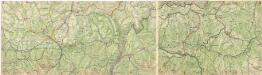
Vysoké Tatry

Mapa gospodarczo-osadnicza pasterstwa w Tatrach = Carte de la vie économique des bergers et leurs établissements dan les Tatra : i mapka etnograficzna z zasięgem wędrówek pasterskich i typów szałaśniczych : et petite carte ethnographique avec l'extension des migrations pastorales et des types des chalets
1 : 75000 Holub-Pacewiczowa, Zofia; Wojskowy instytut geograficzny [Warszawa] : Wojsk. Instyt. Geograf.
[Gradkartenblatt]
1 : 25000 Polsko Vojenský zeměpisný ústav
[Gradkartenblatt]
1 : 25000 Polsko
[Gradkartenblatt]
1 : 25000 Polsko Vojenský zeměpisný ústav
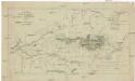
[Náčrt z Tater]
Tatry (Polsko a Slovensko : pohoří) Kořistka, Karel František Edvard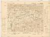
Zakopane NO
1 : 25000 Polsko Reichsamt für Landesaufnahme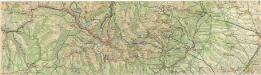
Vysoké Tatry

[Gradkartenblatt]
1 : 25000 Slovensko Vojenský zeměpisný ústav
[Gradkartenblatt]
1 : 25000 Slovensko Vojenský zeměpisný ústav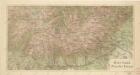
Hohe Tatra

[Gradkartenblatt]
1 : 25000 Slovensko Vojenský zeměpisný ústav
[Gradkartenblatt]
1 : 25000 Slovensko Vojenský zeměpisný ústav
III. vojenské mapování 4364/2
1 : 25000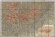
Podrobná mapa Vysokých Tater
1 : 25000 Vysoké Tatry, pohoří-oblast (Polsko a Slovensko) Čs. voj. zeměpisný ústav
Vysoké Tatry
Mappa physico-geographica Carpatorum principalium e quibus Wagus et Dunajetz origines trahunt
1 : 190000 Tatry (Polsko a Slovensko) Bojtár, St.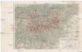
Terrain- und Höhenkarte der Hohen Tatra in den Central-Karpaten
1 : 100000 Vysoké Tatry, pohoří (Polsko a Slovensko) Kořistka, Karel František Edvard Petermann, August Justus Perthes
Terrain- und Höhenkarte der Hohen Tatra in den Central-Karpaten
1 : 100000 Vysoké Tatry, pohoří (Polsko a Slovensko) Kořistka, Karel František Edvard Petermann, August Justus Perthes
Píšova mapa Vysokých Tater
1 : 50000 Vysoké Tatry, pohoří-oblast (Polsko a Slovensko) Gregor, Julius A. Píša
Vysoké Tatry