Maps of Pustomyivskyi District

Lemberg.
from Spezialkarte der osterreichisch-ungarischen Monarchie.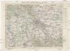
Mapa specjalna okolic Lwowa
1 : 100000 Lvov-oblast (Ukrajina) Książnica – Atlas
Lemberg
1 : 75000 Lvov-oblast (Ukrajina) Scherling K. u. k. Militärgeographisches Institut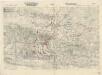
Störungsfeuerskizze
Zu Bildner des Heeres Beilage 20
1 : 29500 Lvov-oblast (Ukrajina) K.k. Schulbücher-Verschleiss-Administration
Plan Lwowa
Lvov (Ukrajina) Dzieduszycki, Maurycy Salzerovi (rodina)
Lemberg mit seinen Vorstaedten
1 : 15200 Lvov (Ukrajina) Krankowich
Jaworow und Crodek.
from Spezialkarte der osterreichisch-ungarischen Monarchie.
[Manöver des 11. Corps 1890]
1 : 75000 Lvov (Ukrajina : oblast) K. u. k. militär-geographisches Institut
Mikolajow und Bobrka.; Spezialkarte der osterreichisch-ungarischen Monarchie.
from Spezialkarte der osterreichisch-ungarischen Monarchie. Austro-Hungarian Monarchy. Militärgeographisches Institut.,
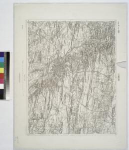
Busk und Krasne
1 : 75000 Ukrajina Fitz, J. K. u. k. Militärgeographisches Institut
Mikołajów und Bórka
1 : 75000 Mykolajiv-oblast (Ukrajina) Bankl, K. K. u. k. Militärgeographisches Institut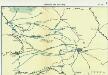
Nr. 6a. Kämpfe in Ostgalizien. Zwischen San und Bug
Galizien Weltkrieg <1914-1918>, Ostfront
General-Karte des Königreiches Galizien und des Herzogthumes Bukovina

Zolkiew (Galizien).
from Spezialkarte der osterreichisch-ungarischen Monarchie.
Generalkarte von Zentraleuropa

Generalkarte von Zentraleuropa


Busk und Krasne.
from Spezialkarte der osterreichisch-ungarischen Monarchie.
Uebersichtsblatt zum Kriegsspielplan der umgebung von Grodek

Jaworów und Gródek
1 : 75000 Ukrajina Charlemont K. u. k. Militärgeographisches Institut
Żołkiew
1 : 75000 Berger K. u. k. Militärgeographisches Institut
Rawa Ruska.
from Spezialkarte der osterreichisch-ungarischen Monarchie.
Przemyslany.
from Spezialkarte der osterreichisch-ungarischen Monarchie.
Kamionka Strumilowa.
from Spezialkarte der osterreichisch-ungarischen Monarchie.
Rudki und Komarno.; Spezialkarte der osterreichisch-ungarischen Monarchie.
from Spezialkarte der osterreichisch-ungarischen Monarchie. Austro-Hungarian Monarchy. Militärgeographisches Institut.,
Strecke
Ivano-Frankivsk (Ukrajina) K. k. Österreichische Staatsbahnen
Russia
Mollova mapová sbírka Hoffmann, Johannes Hoffmann, Johann