Maps of Bielsko County

Bielitz und Biala.
from Spezialkarte der osterreichisch-ungarischen Monarchie.
Bielitz und Biała
1 : 75000 Bielsko-Biała-oblast (Polsko) Bloschitz, R. K. u. k. Militärgeographisches Institut
Bielitz und Biała
1 : 75000 Bielsko-Biała (Polsko : oblast) Otawa K. u. k. militär-geographisches Institut
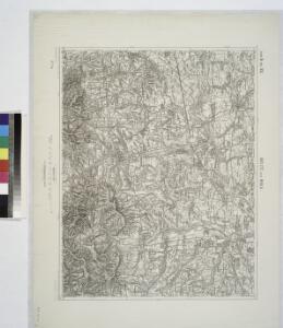
Bielitz und Biała
1 : 75000 Bielsko-Biała (Polsko : oblast) Otawa K. u. k. Militärgeographisches Institut
Podrobná mapa Markrabství moravského a Vévodství slezkého
1 : 100000 Biała (Polsko : oblast) Srp, Jan Jos. R. Vilímek


Meßtischblatt 6080 : Grzawa, 1934
1 : 250000 Grzawa. - Aufn. 1881, hrsg. 1883, letzte Nachtr. 1934. - 1:25000. - [Berlin]: Reichsamt für Landesaufnahme, 1934. - 1 Kt.
Meßtischblatt 3451 : Pless, 1883
1 : 250000 Pless. - Aufn. 1881. - 1:25000. - [Berlin]: Kgl. Preuss. Landesaufnahme, 1883. - 1 Kt.
Stabilní katastr - Pracovní otisk - Brzeszcze in Galizien přehledka
1 : 28800
Stabilní katastr - Pracovní otisk - Brzeszcze in Galizien V
1 : 2880
Stabilní katastr - Pracovní otisk - Brzeszcze in Galizien VIII
1 : 2880
Stabilní katastr - Pracovní otisk - Brzeszcze in Galizien II
1 : 28800
Stabilní katastr - Pracovní otisk - Brzeszcze in Galizien X
1 : 2880
Stabilní katastr - Pracovní otisk - Brzeszcze in Galizien III
1 : 2880
Meßtischblatt 6178 : Petersdorf, 1883
1 : 250000 Petersdorf. - 1:25000. - [Berlin]: Reichsamt für Landesaufnahme, 1883. - 1 Kt.
Meßtischblatt 6078 : Pawlowitz, 1912
1 : 250000 Pawlowitz. - Aufn. 1882, hrsg. 1884, gedr. [19]12. - 1:25000. - [Berlin]: Preuss. Landesaufnahme, 1912. - 1 Kt.
Ober Lischna (Gorni Lyszna) - m0797-1-006 - Kaiserpflichtexemplar der Landkarten des stabilen Katasters
1 : 2880
Ober Lischna (Gorni Lyszna) - m0797-1-001 - Kaiserpflichtexemplar der Landkarten des stabilen Katasters
1 : 2880
Ober Lischna (Gorni Lyszna) - m0797-1-002 - Kaiserpflichtexemplar der Landkarten des stabilen Katasters
1 : 2880
Ober Lischna (Gorni Lyszna) - m0797-1-003 - Kaiserpflichtexemplar der Landkarten des stabilen Katasters
1 : 2880
Ober Lischna (Gorni Lyszna) - m0797-1-004 - Kaiserpflichtexemplar der Landkarten des stabilen Katasters
1 : 2880
Ober Lischna (Gorni Lyszna) - m0797-1-007 - Kaiserpflichtexemplar der Landkarten des stabilen Katasters
1 : 2880
Ober Lischna (Gorni Lyszna) - m0797-1-005 - Kaiserpflichtexemplar der Landkarten des stabilen Katasters
1 : 2880
DVCATVS | OSWIECZENSIS, | et | ZATORIENSIS.
[Amsterdam : Joan Blaeu]
Ducatus Oswieczensis, Et Zatoriensis, Descriptio. [Karte], in: Theatrum orbis terrarum, S. 375.
1 Karte aus Atlas Ortelius, Abraham Vrients, Jan Baptista
Ducatus Oswieczensis, Et Zatoriensis, Descriptio. [Karte], in: Theatrum orbis terrarum, S. 280.
1 Karte aus Atlas Ortelius, Abraham
157. Pless, uit: Topographische Uebersichtskarte des Deutschen Reiches / herausgegeben v. d. Kartogr. Abt. d. Königl. Preuß. Landesaufnahme
1 : 200000 titelvariant: Topogr. Übersichtskarte des Deutschen Reiches; Annotatie: Titel boven bladen ook: Topogr. Übersichtskarte des Deutschen Reiches; Annotatie geografische gegevens: Op elk blad twee maatstokken: 10 Kilometer = 5,5 cm; 1 geogr. Meile = 3,6 cm; Legenda onder op elk blad Königlich Preußische Landesaufnahme. Kartographische Abtheilung [S.l : Königlich Preußische Landesaufnahme, Kartographische Abtheilung]