Maps of powiat rzeszowski

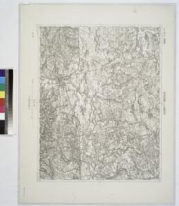
Rzeszow und Lancut.
from Spezialkarte der osterreichisch-ungarischen Monarchie.
Rzeszów und Łańcut
1 : 75000 Polsko Baumgarten K. u. k. Militärgeographisches Institut

Rudnik und Ranizow.
from Spezialkarte der osterreichisch-ungarischen Monarchie.
Ropczyce und Debica.
from Spezialkarte der osterreichisch-ungarischen Monarchie.
Jaroslau.
from Spezialkarte der osterreichisch-ungarischen Monarchie.
Tyczyn und Dynow.; Spezialkarte der osterreichisch-ungarischen Monarchie.
from Spezialkarte der osterreichisch-ungarischen Monarchie. Austro-Hungarian Monarchy. Militärgeographisches Institut.,
Tyczyn und Dynów
1 : 75000 Dynów (Polsko) Fenzel K. u. k. Militärgeographisches Institut
Rzeszów 94, uit: Special-Karte von Mittel-Europa / nach amtlichen Quellen bearbeitet von W. Liebenow
1 : 300000 titelvariant: W. Liebenow's Mittel-Europa; Annotatie: Titel boven de bladen: W. Liebenow's Mittel-Europa Johannes Wilhelm Liebenow 1822-1897 Frankfurt a. M. : Ludwig Ravenstein
Die vom 2. bis 7. Mai 1915 abends erreichten Linien
1 : 515000 Polen Tarnów Weltkrieg <1914-1918> Verl. Gerhard Stalling, Oldenburg
Ropczyce und Debica
1 : 75000 Dębica (Polsko) Jersche K. u. k. Militärgeographisches Institut
Rudnik und Raniszow
1 : 75000 Richter K. u. k. Militärgeographisches Institut
Mielec und Majdan.
from Spezialkarte der osterreichisch-ungarischen Monarchie.
Przemysl.
from Spezialkarte der osterreichisch-ungarischen Monarchie.
Lezajsk.
from Spezialkarte der osterreichisch-ungarischen Monarchie.
Brzostek und Strzyzow.
from Spezialkarte der osterreichisch-ungarischen Monarchie.
Przemyśl
1 : 75000 Polsko Fenzel K. u. k. Militärgeographisches Institut
Przemyśl
1 : 75000 Polsko Fenzel K. u. k. militär-geographisches Institut
Jaroslau
1 : 75000 Polsko Bankl K. u. k. Militärgeographisches Institut
Jaroslau
1 : 75000 Polsko Bankl K. u. k. Militärgeographisches Institut
Brzostek und Strzyżów
1 : 75000 Polsko Charlemont K. u. k. militär-geographisches Institut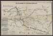
Übersichtskarte des Kampfgeländes
1 : 650000 Polen Tarnów Weltkrieg <1914-1918> Verl. Gerhard Stalling, Oldenburg
Ost-Galizien
Halič (Polsko a Ukrajina) Liesganig, Joseph im Verlage des Kunst und Industrie Comptoirs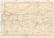
Galizien, Westlicher Theil
1 : 700000 Halič (Polsko a Ukrajina) Karl Fr. Pfau
Carte de la Roumanie et pays limitrophes. Cracovie
1 : 500000 France. Service géographique de l'armée [Paris] : Service géographique de l'armée
Krakau, Przemysl, Jaroslau, Kaschau, Leutschau
1 : 750000 Krakov (Polsko : oblast) Geng, K. K. u. k. Militärgeographisches Institut
Krakau, Przemysl, Jaroslau, Kaschau, Leutschau
1 : 750000 Krakov (Polsko : oblast) Geng, K. K. u. k. Militärgeographisches Institut
Krakau, Przemyśl, Jaroslau, Kaschau, Leutschau
1 : 750000 Jarosław (Polsko) R. Lechner
Krakau, Przemyśl, Jaroslau, Kaschau, Leutschau
1 : 750000 Jarosław (Polsko) K. k. militär-geographisches Institut