Maps of South Africa

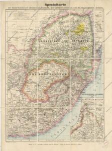
Specialkarte der Südafrikanischen- (Transvaal) Republik

Union of South Africa Special Map Accompanying Richmond's South African All Mining Year Book (Sheet 2)
Union of South Africa. Special map accompanying Richmond's South African All Mining Year Book illustrating the location of Mines, Quarries and Works. Johannesburg : Hortors
W. H. Smith & Son's War map of the Transvaal and adjoining countries in South Africa
1 : 2700000 J. Bartholomew London : Smith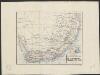
De Kaapkolonie, Transvaal en aangr. landen : periodieke rivieren
1 : 9250000 lith. Emrik & Binger [S.l.] : [s.n.]
Die Südspitze von Africa mit der Colonie der Guten Hoffnung und dem Kaffern-Lande oder Südrand von Africa und dessen Stufenlaender
1 : 3000000 Jihoafrická republika Weiland, Karl Ferdinand Geograph. Instituts
South Africa [Mineral map of the Union of ] (1959)
Mineral Map of the Union of South Africa. To accompany the handbook, The Mineral Resources of the Union of South Africa" 1959. Delfstofkaart van die Unie van Suid-Afrika." Legends in English and Afrikaans. [Pretoria] : Department of Mines, Union of South Africa.
Sud-Africa.
1 : 4700000 Flemming, Carl
Südafrikanische (Transvaal-) Republik, Oranje-Freistaat und angrenzende Gebiete
1 : 3000000 Afrika jižní Carl Flemming
Oorlogskaart van Zuid-Afrika 1899-1900 / bew. te Pretoria naar officieele gegevens
1 : 1250000 Rotterdam : Nijgh & Van Ditmar
Sudafrica.
1 : 5250000 Radefeld, Carl Christian Franz, 1788-1874
Südafrikanische Republik (Transvaal) und Oranje-Freistaat
1 : 5000000 G. Freytag & Berndt
Southern Africa.
1 : 3100000 Hall, S. (Sidney)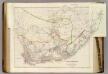
Cape of Good Hope.
1 : 2407680 Arrowsmith, John
Carte du théatre de la guerre Sud Africaine
1 : 6000000 Favre, Camille Schlumpf
Zuid-Afrikaansche Republiek, Oranje-Vrijstaat, Natal, enz
1 : 2500000 titelvariant: Kaart der Zuid-Afrikaansche Republiek, (Transvaal) Oranje-Vrijstaat, Natal enz; Annotatie: Omslagtitel: Kaart der Zuid-Afrikaansche Republiek, (Transvaal) Oranje-Vrijstaat, Natal enz. (met de spoorwegen); Annotatie geografische gegevens: Legenda Amsterdam : Seyffardt's Boekhandel / ([S.l. : Mij. voor photolithogr & zincographie, procédé mr. F.J. Asser])
Cape of Good Hope
1 : 1909000 Mys dobré naděje (Jihoafrická republika) Arrowsmith, John J. Arrowsmith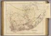
Cape of Good Hope.
1 : 2350000 Arrowsmith, John
Recto, uit: W. & A. K. Johnston's pictorial bird's-eye map of the Transvaal, Orange Free State, Natal, &c
1 : 1175000 titelvariant: Johnston's pictorial bird's-eye map of the Transvaal, Orange Free State, Natal, &c; Annotatie: Omslagtitel: Johnston's pictorial bird's-eye map of the Transvaal, Orange Free State, Natal, &c Edinburgh [etc.] : W. & A.K. Johnston
Cape Province, Transvaal, &c. - eastern section.
1 : 2500000 John Bartholomew and Son
South African Republic (Transvaal) and the surrounding territories
1 : 1850000 Jeppe, F. Londres : S. W. Silver & Co.
Kaart van de Zuid-Afrikaansche Republiek (Transvaal)
1 : 1500000 Den Haag : J. Smulders
Oorlogskaart : spoorlijn De Aar-Mafeking en westelijke districten der Zuid-Afrikaansche Republieken
1 : 1000000 titelvariant: Kaart der spoorlijn De Aar-Mafeking en westelijke districten der Z.A. Republieken tot Naauwpoort-Bloemfontein-Potchefstroom-Rustenburg; Annotatie: Omslagtitel: Kaart der spoorlijn de Aar-Mafeking en westelijke districten der Z.A. Republieken tot Naauwpoort-Bloemfontein-Potchefstroom-Rustenburg : Oorlogskaart No. 3; Annotatie geografische gegevens: Legenda Amsterdam : Seyffardt / (Amsterdam : Senefelder)
Natal And Kaffraria.
1 : 2640000 Tallis, J. & F.
Charte der Südspize von Africa oder des Hottentotten und Caplands
Afrika jižní
CHARTE der SÜDSPIZE von AFRICA oder des HOTTENTOTTEN und CAPLANDS
Afrika jižní
Cap de Bonne Esperance. Afrique 54.
1 : 1641836 Vandermaelen, Philippe, 1795-1869
Pays des Hottentots. Afrique 51.
1 : 1641836 Vandermaelen, Philippe, 1795-1869
Special-Karte des Zulu-Landes, der angrenz. britischen Colonial-Territorien Natal und Transvaal u. d. portugiesischen Besitzungen an der Delagoa Bay
1 : 1600000 Mpumalanga (Jihoafrická republika) W. Nagel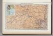
175. Republic of South Africa. Capetown. The World Atlas.
1 : 1250000 USSR (Union of Soviet Socialist Republics).