Maps of Rostock
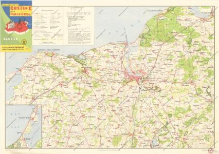
Wanderkarte Rostock und Umgebung

Composite: 86. Rostock. (Germany)
1 : 100000 Reichsamt fur Landesaufnahme
86. Rostock. (Germany)
1 : 100000 Reichsamt fur Landesaufnahme
Composite: 85. Kropelin. (Germany)
1 : 100000 Reichsamt fur Landesaufnahme
85. Kropelin. (Germany)
1 : 100000 Reichsamt fur Landesaufnahme
Meßtischblatt 586 : Petschow, 1930
1 : 250000 Petschow. - Hrsg. 1879, bericht. 1927, einz. Nachtr. 1930. - 1:25000. - [Berlin]: Reichsamt für Landesaufnahme, 1930. - 1 Kt.
Meßtischblatt 586 : Petschow, 1898
1 : 250000 Petschow. - Aufn. 1877, hrsg. 1879, einz. Nachtr. 1898. - 1:25000. - [Berlin]: Reichsamt für Landesaufnahme, 1898. - 1 Kt.
Meßtischblatt 1938 : Rostock, 1937
1 : 250000 Rostock. - Hrsg. 1879, bericht. 1927, gedr. [19]37. - 1:25000. - [Berlin]: Reichsamt für Landesaufnahme, 1937. - 1 Kt.
Meßtischblatt 585 : Rostock, 1898
1 : 250000 Rostock. - Aufn. 1877, hrsg. 1879, einz. Nachtr. 1898. - 1:25000. - [Berlin]: Reichsamt für Landesaufnahme, 1898. - 1 Kt.
Meßtischblatt 584 : Hanstorf, 1888
1 : 250000 Hanstorf. - Aufn. 1877, hrsg. 1879, einz. Nachtr. 1888. - 1:25000. - [Berlin]: Reichsamt für Landesaufnahme, 1888. - 1 Kt.
Meßtischblatt 583 : Kröpelin, 1927
1 : 250000 Kröpelin. - Hrsg. 1879, bericht. 1927. - 1:25000. - [Berlin]: Reichsamt für Landesaufnahme, 1927. - 1 Kt.
Meßtischblatt 1839 : Bentwisch, 1927
1 : 250000 Bentwisch. - Hrsg. 1879, bericht. 1927. - 1:25000. - [Berlin]: Reichsamt für Landesaufnahme, 1927. - 1 Kt.
Meßtischblatt 507 : Bentwisch, 1892
1 : 250000 Bentwisch. - Aufn. 1877, hrsg. 1879, einz. Nachtr. 1892. - 1:25000. - [Berlin]: Reichsamt für Landesaufnahme, 1892. - 1 Kt.
Meßtischblatt 1838 : Warnemünde, 1936
1 : 250000 Warnemünde. - Hrsg. 1879, bericht. 1927, letzte Nachtr. 1928, gedr. [19]36. - 1:25000. - [Berlin]: Reichsamt für Landesaufnahme, 1936. - 1 Kt.
Meßtischblatt 506 : Warnemünde, 1892
1 : 250000 Warnemünde. - Aufn. 1877, hrsg. 1879, einz. Nachtr. 1892. - 1:25000. - [Berlin]: Reichsamt für Landesaufnahme, 1892. - 1 Kt.
Meßtischblatt 1837 : Bad Doberan, 1927
1 : 250000 Bad Doberan. - Hrsg. 1879, Ausg. 1927. - 1:25000. - [Berlin]: Reichsamt für Landesaufnahme, 1927. - 1 Kt.
Meßtischblatt 505 : Doberan, 1886
1 : 250000 Doberan. - Aufn. 1877, hrsg. 1879, einz. Nachtr. 1886. - 1:25000. - [Berlin]: Reichsamt für Landesaufnahme, 1886. - 1 Kt.
Meßtischblatt 1836 : Kühlungsborn (Ostseebad), 1927
1 : 250000 Kühlungsborn (Ostseebad). - Hrsg. 1897, Ausg. 1927. - 1:25000. - [Berlin]: Reichsamt für Landesaufnahme, 1927. - 1 Kt.
Meßtischblatt 670 : Hohen Sprenz, 1928
1 : 250000 Hohen Sprenz. - Aufgen. 1880, hrsg. 1882, bericht. 1928. - 1:25000. - [Berlin]: Reichsamt für Landesaufnahme, 1928. - 1 Kt.
Meßtischblatt 669 : Schwaan, 1928
1 : 250000 Schwaan. - Aufgen. 1880, hrsg. 1882, bericht. 1828. - 1:25000. - [Berlin]: Reichsamt für Landesaufnahme, 1928. - 1 Kt.
Meßtischblatt 669 : Schwaan, 1882
1 : 250000 Schwaan. - Aufn. 1880. - 1:25000. - [Berlin]: Reichsamt für Landesaufnahme, 1882. - 1 Kt.
Meßtischblatt 668 : Neu- Kirchen, 1882
1 : 250000 Neu- Kirchen. - Aufn. 1880. - 1:25000. - [Berlin]: Reichsamt für Landesaufnahme, 1882. - 1 Kt.
Meßtischblatt 2036 : Kirch, Mulsow, 1938
1 : 250000 Kirch, Mulsow. - Hrsg. 1879, kleine Nachtr. 1919, redakt. Änd. 19. - 1:25000. - [Berlin]: Reichsamt für Landesaufnahme, 1938. - 1 Kt.
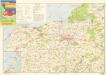
Bädekarte Kühlungsborn und Umgebung
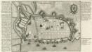
Rostock.
Mollova mapová sbírka Bodenehr, Gabriel Bodenehr, Gabriel
Meßtischblatt 587 : Tessin, 1930
1 : 250000 Tessin. - Hrsg. 1885, bericht. 1927, einz. Nachtr. 1930. - 1:25000. - [Berlin]: Reichsamt für Landesaufnahme, 1930. - 1 Kt.
Meßtischblatt 587 : Tessin, 1898
1 : 250000 Tessin. - Aufn. 1884, hrsg. 1885, einz. Nachtr. 1898. - 1:25000. - [Berlin]: Reichsamt für Landesaufnahme, 1898. - 1 Kt.
Meßtischblatt 508, neue Nr. 1840 : Dänschenburg, 1927
1 : 250000 Dänschenburg. - Hrsg. 1885, bericht. 1927. - 1:25000. - [Berlin]: Reichsamt für Landesaufnahme, 1927. - 1 Kt.
Meßtischblatt 508 : Dänschenburg, 1892
1 : 250000 Dänschenburg. - Aufn. 1884, hrsg. 1885, einz. Nachtr. 1892. - 1:25000. - [Berlin]: Reichsamt für Landesaufnahme, 1892. - 1 Kt.