Maps of Japan

Asie

Japanese Empire - political.
1 : 6000000 John Bartholomew and Son
JAPON

JAPON
Japan.
1 : 2600000 Rand McNally and Company
Neue Charte von der Nordost-Küste von Asien und den Japanischen Inseln
Asie východní Vashon, T. G. Götz, J. im Verlage des Geograph. Instituts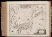
Nova et accvrata Iaponiæ, Terræ Esonis ac insularum adjacentium ex novißima detectione descriptio
1 : 5000000 Annotatie: Beschreven in: Koeman, Atlantes Neerlandici II, p. 443-444; Zeekaart; Origineel is Blad 198 in atlas factice; Annotatie geografische gegevens: Schaalstok, verlopend over 32o tot 50o van 42 Milliaria Germanica Johannes Janssonius 1588-1664 [Amstelodami : Apud Ioannem Ianßonium]
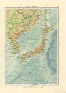
Japan and Korea.
1 : 6198300 Johnston, W. & A.K.
Nova Et Accurata Iaponiae, Terrae Esonis, ac Insularum adiacentium. ex Novißimâ detectione descriptio. [Karte], in: Novus atlas absolutissimus, Bd. 6, S. 139.
1 Karte aus Atlas Janssonius Offizin
Karte des ostasiatischen Kriegsschauplatzes
1 : 11000000 Asie východní Hofbuchdruckerei A. Haase
Maps of the Far East, illustrating Russo-Japanese War
1 : 6000000
Japan, Mandshuria (showing the course of the Amur river), the Kurile Isles &c. : according to the British & Russian Admiralty surveys, Krusenstern, Siebold &c. / by J. Bartholomew Jun.r ; engraved by J. Bartholomew
1 : 9000000 titelvariant: Islands of Japan; Annotatie: Uit: The Royal illustrated atlas of modern geography. - London [etc.] : A. Fullarton & Co., 1860; Lit: A list of geographical atlases, I, no. 838; Titel boven de kaart: Islands of Japan Bartholomew, John (1831-1893) Edinburgh [etc.] : A. Fullarton & Co.
JAPANESE EMPIRE-POLITICAL

U.S.S.R. - Far East, Korea, Japan. Pergamon World Atlas.
1 : 5000000 Polish Army Topography Service
Japan a Korea
1 : 8000000 Japonsko nákladem J. Otty
Kaart van Japan / [getekend door] R. van Wijk
Dordrecht : J. de Vos
Kaart van Japan : behoorende tot de, door het Provinciaal Utrechtsch Genootschap bekroonde Verhandeling van R.G. Bennet en J. van Wyk Rz.
1 : 4500000 R. van Wyk Jz. del. Te Dordrecht : by J. de Vos & Co.
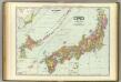
Japan, 36
1 : 4700000 Appleton, D. & Co.
Japan.
1 : 5000000 Vivien St Martin, L.
Map of the Japan Islands
1 : 7000000 Maury, William L J. Ackerman
Asia 1:4 000 000
1 : 4000000 Asie War Office
et des Rojaumes de COREE ET IAPAN

Japan. Coal Resources of the World.
1 : 5000000 McInnes, William; Leach, W.W.; Dowling, D.B.
Impero del Giappone.
1 : 4450000 Society for the Diffusion of Useful Knowledge (Great Britain)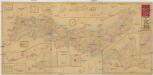
Shinsen Dainihon Zenzu
1 : 2200000 Japonsko Sagano, Hikotaro Sagano Hikotaro
Japan and Korea. Iran (Persia), Afghanistan, and Baluchistan.
1 : 6190000 Hammond, C.S.
Japon.
1 : 5000000 Migeon, J.
Bojiště rusko-japonské ve východní Asii
1 : 4500000 Japonsko Kotrba, V.
Bojiště rusko-japonské ve východní Asii
1 : 4500000 Japonsko