Maps of Sisacko-Moslavacka

Übersichtskarte von Mittel - Europa

Übersichtskarte von Mittel - Europa

Agram, Brod, Esseg, Glina, Knin, Sarajevo
1 : 750000 Knin (Chorvatsko : oblast) K. u. k. militär-geographisches Institut
Agram, Brod, Esseg, Glina, Knin, Sarajevo
1 : 750000 Glina (Chorvatsko) K. k. militär-geographisches Institut
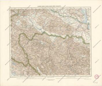
Zagreb, Brod, Osijek, Glina, Knin, Sarajevo
1 : 750000 Glina (Chorvatsko) Cronenberg, E. K. u. k. Militärgeographisches Institut
Agram, Brod, Esseg, Glina, Knin, Sarajevo
1 : 750000 Glina (Chorvatsko) K. u. k. Militärgeographisches Institut
Das Königreich Bosnien, und die Herzegovina (Rama)
Bosnien, Herzegowina
Schlavoniae, Croatiae, Carniae, Istriae, Bosniae, Finitimarvmqve Regionvm Nova descriptio
1 : 520000 Mollova mapová sbírka Hirschvogel, Augustin Plantin, Christoph
XIII, uit: General-Karte des oesterreichischen Kaiserstaates mit einem grossen Theile der angrenzenden Länder / durch Josef Scheda ... bearb. und hrsg
1 : 576000 Annotatie geografische gegevens: Maatstokken: oesterreichische Meilen, geografische oder deutsche Meilen, preussische Meilen, türkische Berri, französische Lieues, russische Werste; Maatstok per blad: wiener Klafter, öster. Meilen; Blad XIX: statistische en taalkundige informatie; Blad XIX: legenda [Wien : K.K. Militärisch-Geografisches Institut]
Königreich Kroatien nach der neuesten Begrenzung, und den vorzüglisten Hülfsmitteln bearbeitet
1 : 930000 Chorvatsko Tranquillo Mollo
Sclavonia. Bosnia
Mollova mapová sbírka Hoffmann, Johannes Hoffmann, Johann
Mappa generalis regni Hungariae partiumque adnexarum Croatiae, Slavoniae...
Tabula Geographica Nova et Exacta Distincte exhibens Regnum Sclavoniae cum Syrmii Ducatu
1 : 300000 Mollova mapová sbírka Gadea, Joseph Schmuzer, Johann Adam Schmuzer, Johann Andreas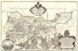
Tabula Geographica Nova et Exacta Distincte exhibens Regnum Sclavoniae cum Syrmii Ducatu
1 : 300000 Mollova mapová sbírka Gadea, Joseph
Bosnia & Hercegovina
Bosna a Hercegovina Jordán, J. P. J.P. Jordán
Letecká mapa Evropy

Strassen Karte der croatischen Militair Grenze
1 : 440000 Bosna a Hercegovina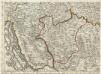
Augustissimo Romanor. Imperatori Iosepho I. Hungaria Regi Invictissimo Mappam Hanc Regni Hungariae
1 : 540000 Mollova mapová sbírka Müller, Johann Christoph
Vermehrte und Verbesserte Landkarten des Königreichs Ungarn :
1 : 500000 Mollova mapová sbírka Stier, Martin Böner, Johann-Alexander Endter, Martin
Franz Maurer ́s Routen in Bosnien 1868 nach dessen Skizzen und Reisetagebuch
Bosnien-Herzegowina, Bosnien, Reiseweg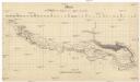
Skelett zur Übersicht der Savestrecke von Agram bis Semlin
1 : 580000 Záhřeb-oblast (Chorvatsko)
Tabula Geographica Nova Et Exacta Distincte Exhibens Regnum Sclavoniae Cum Syrmii Ducatu Quod A Fluvus Savi Illovae Dravi Et Danubii Allitur Eius Provinitiae Conterminae Sunt Regnum Hungariae Croatiae Bosniae Serviae Et Bannatus Temesvrensis
Sirmien, Bosnien, Požarevac / Friede Khevenhüller-Frankenburg, Ludwig Andreas von, http://d-nb.info/gnd/116153849
Croatia
Mollova mapová sbírka Hoffmann, Johannes Hoffmann, Johann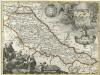
Regnum Slavoniae
1 : 1100000 Mollova mapová sbírka Bruggen, Johann van der Brugge, Johannes van der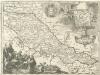
Regnum Slavoniae
1 : 1100000 Mollova mapová sbírka Bruggen, Johann van der Brugge, Johannes van der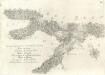
Accuratissima totius Savi area, in VI. Tabulis Geographicis repreasentata ab utraqve sua Origine usqve ad Illapsum in Danubium: nec non totius Labaci Fluvii una cum incurrentibus Fluminibus et adjacentibus Locis ac confiniis].
Mollova mapová sbírka Renner, F. C. Kaltschmidt, Abraham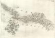
Pars Regni Croatiae
Mollova mapová sbírka Renner, F. C. Kaltschmidt, Abraham
Pars Styriae Pars Regni [Ca]rnioliae Croatiae
Mollova mapová sbírka Renner, F. C. Kaltschmidt, Abraham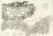
Ausführlicher Plan des gantzen Sau-Stroms, in VI. Tabellen vorgestellet, von seinen beyden Ursprüngen bis Zum Einfall in die Donau: wie auch des gantzen Laybaci-Flusses, sambt allen darein-fallengen Elüssen und daran liegenden Orthern, und Gränitzen.
Mollova mapová sbírka Renner, F. C. Kaltschmidt, Abraham